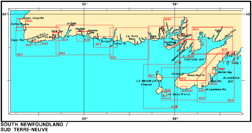
Federal Publications logo FEDERAL
PUBLICATIONS
INC.

Navigation Bar Checkout View Cart E-mail Us Canadian Maps and Charts Books on Canada Home

Nautical Charts for South Newfoundland

Looking for nautical charts of the south coast of Newfoundland? See below for an index to charts produced by Canadian Hydrographic Service - detailed information is available by scrolling down and clicking on an area of the map.

If you do not see what you are looking for, please feel free to ask us.
Please Note:
  • Charts are normally sent rolled in a tube for orders shipped within Canada and the United States. Charts sent to other countries are sent folded. If you would prefer to make alternate arrangements, please specify at the time of ordering. Charts sent rolled in a tube to the U.S. by mail usually take longer to arrive than folded orders.
  • Some charts are only available pre-folded, as indicated beside the chart title. These charts are only available folded, not rolled.
  • All charts are on paper, and not available in waterproof unless indicated.

 
Nautical Charts for South Newfoundland The Burgeo and Ramea Islands The Burgeo and Ramea Islands Wreck Island to Cinq Cerf Bay Garia and Le Moine Bays Isle aux Morts and Approaches Port aux Basques and Approaches Larkin Point to Cape Anguille Cape Ray to La Poile Bay La Poile Bay to Ramea Islands Ramea Islands to Bonne Bay Bay d'Espoir and Hermitage Bay Great Bay de l'eau and Approaches/et les approches Īle Saint-Pierre (France) St Lawrence and Lamaline Harbours St Lawrence and Lamaline Harbours Burin Harbours Mortier Bay Harbours in Placentia Bay (Petit Forte to Broad Cove Head) Fortune Bay - Northern Portion/Partie nord Fortune Bay - Southern Portion/Partie sud Burin Peninsula to Saint-Pierre Saint-Pierre and Miquelon (France) Long Island to St. Lawrence Harbours
Chart Number Name Scale Price  
4587 Mortier Bay
-Marystown Wharves
-Fishery Products International Wharves
1:12 000
1:3 000
1:3 000
$20.00 Add to Cart
4615 Harbours in Placentia Bay (Petit Forte to Broad Cove Head) 1:25 000 $20.00 Add to Cart
4616 Burin Harbours
-Burin Government Wharf
1:20 000
1:1 200
$20.00 Add to Cart
4624 Long Island to St. Lawrence Harbours 1:80 000 $20.00 Add to Cart
4625 Burin Peninsula to Saint-Pierre 1:75 000 $20.00 Add to Cart
4626 Saint-Pierre and Miquelon (France) 1:75 000 $20.00 Add to Cart
4826 (Replaces 4633) Burgeo to Francois
-Grey River
-Francois
1:75 000
1:15 000
1:15 000
$20.00 Add to Cart
4638 Wreck Island to Cinq Cerf Bay including Connoire, Muddy Hole and Couteau Bays 1:24 300 $20.00 Add to Cart
4639 Garia and Le Moine Bays 1:24 300 $15.00 Add to Cart
4640 Isle aux Morts and Approaches
-Margaree Harbour
-Nelpack Fisheries Wharf
-Public Wharf
1:10 000
1:2 400
1:2 400
1:2 400
$20.00 Add to Cart
4641 Port aux Basques and Approaches
-Channel Port aux Basques Waterfront
1:7 500
1:3 600
$20.00 Add to Cart
4642 St Lawrence and Lamaline Harbours
-St Lawrence Harbours
-Great St Lawrence Harbour (Inner Portion)
-Lamaline Harbour
1:20 000
1:20 000
1:6 000
1:20 000
$20.00 Add to Cart
4643 Île Saint-Pierre (France) 1:15 000 $20.00 Add to Cart
4644 Bay d'Espoir and Hermitage Bay 1:50 000 $20.00 Add to Cart
4682 Larkin Point to Cape Anguille
-Codroy Harbour
1:20 000
1:6 000
$20.00 Add to Cart
4823 (Replaces 4635) Cape Ray to/à Garia Bay  1:75,000 $20.00 Add to Cart
4825 The Burgeo and Ramea Islands
- Ship Cove
- Burgeo

1:30 000
1:7 500
1:12 000
$20.00 Add to Cart
4830 Great Bay de l'eau and Approaches
-Harbour Breton
1:30 000
1:10 000
$20.00 Add to Cart
4831 Fortune Bay - Northern Portion 1:60 000 $20.00 Add to Cart
4832 Fortune Bay - Southern Portion
-Grand Bank Harbour
-Fortune Harbour
1:60 000
1:5 000
1:5 000
$20.00 Add to Cart

Related Sections:
  Atlantic Chart Index
  General Atlantic Charts
  Coastal Atlantic Charts
  Anticosti Island Charts
  Avalon Peninsula Charts
  Bay of Fundy Charts
  Cape Breton Island Charts
  Central Nfld Charts
  Central Nova Scotia Charts
  Chaleur Bay Charts
  Northern Nfld Charts
  Hudson Strait Charts
  Labrador Sea Charts
  Prince Edward Island Charts
  Southern Nova Scotia Charts
  Southern Nfld Charts
  St. Lawrence Charts

Browse By Type of Map:
  Topographic Maps
  Nautical Charts
  Aeronautical Charts
  Trak Maps and Charts
  Recreation Maps
  Park Maps
  Backroad Mapbooks
  Digital Topographic Maps

Browse By Region:
  Canada
  Alberta
  British Columbia
  Manitoba
  New Brunswick
  Newfoundland
  Northwest Territories
  Nova Scotia
  Nunavut
  Ontario
  Prince Edward Island
  Quebec
  Saskatchewan
  Yukon
Featured Areas:
  Algonquin
  Killarney
  Temagami
  Banff
  Jasper
Outside Canada:
  Maps of the World
  North America

Related Reading:
  Boating in Canada
  Sailing Directions
  List of Lights
  Radio Aids
  Tide and Current Tables
Price and availability subject to change. Shipping and applicable taxes extra.

Can't find what you're looking for? Try the search button at the top of the page.
Questions about anything on this page? Please e-mail us.

Information on this page last updated: April 29, 2009

What's New · Home · Search · Books on Canada · Canadian Maps and Charts · Ordering · E-mail Us
©Federal Publications Inc., 1998 - 2009
425 University Avenue, Ste. 401, Toronto, Ontario, Canada M5G 1T6
Phone: (416) 860-1611 or toll-free 1-888-433-3782 · E-mail: info@fedpubs.com