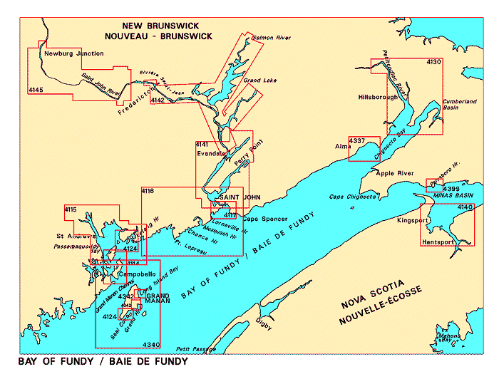
Navigation Bar Checkout View Cart E-mail Us Maps Publications Search Home

Nautical Charts for the Bay of Fundy

Looking for nautical charts for the Bay of Fundy? See below for an index to charts produced by Canadian Hydrographic Service - detailed information is available by clicking on an area of the map.

If you do not see what you are looking for, please feel free to ask us.
Charts for the Bay of Fundy Petitcodiac River and Cumberland Basin Alma and Approaches Parrsboro Harbour and Approaches Avon River and Approaches Grand Harbour Long Island Bay Campobello Island Seal Cove and Approaches/et les approches Letete Passage, Letang Harbour and/et Blacks Harbour Grand Manan Passamaquoddy Bay and/et St-Croix River Approaches to/Approches à Saint John Saint John to/à Evandale Evandale to/à Ross Island Saint John River, Mactaquac Lake, Mactaquac Dam to Newburg Junction

Please Note:
  • Charts are normally sent rolled in a tube for orders shipped within Canada and the United States. Charts sent to other countries are sent folded. If you would prefer to make alternate arrangements, please specify at the time of ordering. Charts sent rolled in a tube to the U.S. by mail usually take longer to arrive than folded orders.
  • Some charts are only available pre-folded, as indicated beside the chart title. These charts are only available folded, not rolled.
  • All charts are on paper, and not available in waterproof unless indicated.
Chart Number Name Scale Price  
4114 Campobello Island
-Eastport Harbour
1:20 000
1:5 000
$20.00 Add to Cart
4115 Passamaquoddy Bay and/et St-Croix River
-Beaver Harbour
-St-Andrews
-Todd's Point
1:50 000
1:15 000
1:15 000
1:15 000
 
$20.00 Add to Cart
4116 Approaches to/Approches à Saint John
-Musquash Harbour
-Dipper Harbour
1:60 000
1:20 000
1:20 000
$20.00 Add to Cart
4117 Saint John Harbour and Approaches/et les approches 1:15 000 $20.00 Add to Cart
4124 Harbours in the Bay of Fundy/Ports dans la baie de Fundy
-Letete Passage, Letang Harbour and/et Blacks Harbour
-Seal Cove and Approaches/et les approches
1:20 000
1:25 000
$20.00 Add to Cart
4130 Petitcodiac River and Cumberland Basin
-Dorchester Cape
1:50 000
1:12 000
$20.00 Add to Cart
4140 Avon River and Approaches
-Hantsport Wharves
1:37 500
1:2 400
$20.00 Add to Cart
4141 Saint John to/à Evandale
- pre-folded
1:30 000 $18.00 Add to Cart
4142 Evandale to/à Ross Island
- pre-folded
1:30 000 $28.00 Add to Cart
4145 Saint John River, Mactaquac Lake, Mactaquac Dam to Newburg Junction
- pre-folded
1:30 000 $18.00 Add to Cart
4337 Alma and Approaches
-Alma
1:25 000
1:2 400
$20.00 Add to Cart
4340 Grand Manan 1:60 000 $20.00 Add to Cart
4342 Harbours in Grand Manan
-Seal Cove
-Long Island Bay
-North Head Wharves
-Grand Harbour
1:12 900
1:12 900
1:3 600
1:25 000
$20.00 Add to Cart
4399 Parrsboro Harbour and Approaches
-Parrsboro Harbour
1:12 200
1:6 000
$20.00 Add to Cart
Price and availability subject to change. Shipping and applicable taxes extra.
Questions about anything on this page? Please e-mail us.
This page last modified: June 11, 2001

Index: Atlantic Coast
What's New · Home · Search · Books on Canada · Canadian Maps and Charts · Ordering · E-mail Us

©Federal Publications Inc., 1998 - 2008
165 University Avenue, Toronto, Ontario, Canada M5H 3B8
Phone: (416) 860-1611 or toll-free 1-888-433-3782 · E-mail: info@fedpubs.com