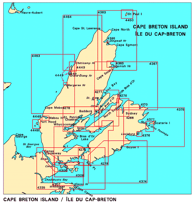
Federal Publications logo FEDERAL
PUBLICATIONS
INC.

Navigation Bar Checkout View Cart Contact Us Canadian Maps and Charts Books on Canada Home

Nautical Charts for Cape Breton Island

For information on charts for Cape Breton Island produced by Canadian Hydrographic Service, click an area of the index below, or see our price list to order.

Digital Charts on CD-ROM are also available for this region.

If you do not see what you are looking for, please feel free to ask us.
Please Note:
  • Charts are normally sent rolled in a tube for orders shipped within Canada and the United States. Charts sent to other countries are sent folded. If you would prefer to make alternate arrangements, please specify at the time of ordering. Charts sent rolled in a tube to the U.S. by mail usually take longer to arrive than folded orders.
  • Some charts are only available pre-folded, as indicated beside the chart title.
  • All charts are printed on paper and are not available in waterproof unless indicated.

 
Charts for Cape Breton Island St. Georges Bay St. Peters Bay Strait of Canso and Southern Approaches/et les approches sud St. Peters Bay to Strait of Canso Canso Harbour to Strait of Canso Red Point to Guyon Island Strait of Canso and Approaches Port Hood Mabou Harbour Great Bras D'Or and/et St. Patricks Channel Bras D'Or Lake Louisburg Harbour Main-à-Dieu Passage Glace Bay Harbour Little Bras D'Or Sydney Harbour Great Bras D'Or, St. Andrews Channel and/et St. Anns Bay Guyon Island to Flint Island Chéticamp Harbour Grand Étang Harbour Margaree Harbour Chéticamp to Cape Mabou Flint Island to Cape Smoky Ingonish Harbour and Approaches Dingwall Harbour St. Paul Island Chéticamp to Cape St. Lawrence Cape Smoky to St. Paul Island
Chart Number Name Scale Price  
4170 Glace Bay Harbour 1:6 000 $11.50 Add to Cart
4266 Sydney Harbour
-North Sydney
-International Piers
-Sydney Wharves/Quais
-Sydney River
-Sydport
1:20 000
1:6 000
1:6 000
1:6 000
1:6 000
1:6 000
$20.00 Add to Cart
4275 St. Peters Bay
-St. Peters Canal
1:20 000
1:5 000
$20.00 Add to Cart
4276 Little Bras D'Or 1:5 000 $20.00 Add to Cart
4277 Great Bras D'Or, St. Andrews Channel and St. Anns Bay
-Entrance to Great Bras D'Or
-Otter Harbour
-Entrance to St. Anns Harbour
1:40 000
1:20 000
1:20 000
1:20 000
$20.00 Add to Cart
4278 Great Bras D'Or and St. Patricks Channel
-MacIvers Pt. to Little Narrows
-Baddeck Harbour
-Iona and Grand Narrows
1:40 000
1:15 000
1:10 000
1:10 000
$20.00 Add to Cart
4279 Bras D'Or Lake
-Lennox Passage
1:60 000
1:40 000
$20.00 Add to Cart
4306 Strait of Canso and Southern Approaches
-Point Tupper to/à Ship Point
-Canso Lock and Causeway
1:25 000
1:12 000
1:10 000
$20.00 Add to Cart
4307 Canso Harbour to Strait of Canso 1:37 500 $20.00 Add to Cart
4308 St. Peters Bay to Strait of Canso
-Petit-de-Grat Inlet
1:37 500
1:20 000
$20.00 Add to Cart
4335 Strait of Canso and Approaches 1:75 000 $20.00 Add to Cart
4363 Cape Smoky to St. Paul Island 1:74 500 $20.00 Add to Cart
4365 Ingonish and Dingwall Harbours
-Ingonish Harbour and Approaches
-Dingwall Harbour
1:200 000
1:18 000
1:4 800
$20.00 Add to Cart
4367 Flint Island to Cape Smoky 1:75 200 $20.00 Add to Cart
4374 Red Point to Guyon Island 1:75 000 $20.00 Add to Cart
4375 Guyon Island to Flint Island 1:75 700 $20.00 Add to Cart
4376 Louisburg Harbour 1:9 600 $20.00 Add to Cart
4377 Main-à-Dieu Passage 1:18 000 $20.00 Add to Cart
4448 Port Hood, Mabou Harbour and Havre Boucher
-Port Hood
-Mabou Harbour
-Havre Boucher

1:18 000
1:12 000
1:12 000
$20.00 Add to Cart
4449 Chéticamp, Grand Étang and Margaree Harbours
-Chéticamp Harbour
-Grand Étang Harbour
-Margaree Harbour

1:12 000
1:6 000
1:6 000
$20.00 Add to Cart
4450 St. Paul Island
-Atlantic Cove
-MacDougall and Powers Coves
-Trinity Cove
1:24 300
1:12 200
1:12 200
1:12 200
$15.00 Add to Cart
4462 St. George's Bay 1:75 200 $20.00 Add to Cart
4463 Chéticamp to Cape Mabou 1:75 000 $20.00 Add to Cart
4464 Chéticamp to Cape St. Lawrence 1:74 500 $20.00 Add to Cart

Related Sections:
  Atlantic Chart Index
  General Atlantic Charts
  Coastal Atlantic Charts
  Anticosti Island Charts
  Avalon Peninsula Charts
  Bay of Fundy Charts
  Cape Breton Island Charts
  Central Nfld Charts
  Central Nova Scotia Charts
  Chaleur Bay Charts
  Northern Nfld Charts
  Hudson Strait Charts
  Labrador Sea Charts
  Prince Edward Island Charts
  Southern Nova Scotia Charts
  Southern Nfld Charts
  St. Lawrence Charts
  Charts on CD-ROM

Browse By Type of Map:
  Topographic Maps
  Nautical Charts
  Aeronautical Charts
  Depth Maps and Charts
  Recreation Maps
  Park Maps
  Backroad Mapbooks
  Digital Topographic Maps

Browse By Region:
  Canada
  Alberta
  British Columbia
  Manitoba
  New Brunswick
  Newfoundland
  Northwest Territories
  Nova Scotia
  Nunavut
  Ontario
  Prince Edward Island
  Quebec
  Saskatchewan
  Yukon
Featured Areas:
  Algonquin
  Killarney
  Temagami
  Banff
  Jasper
Outside Canada:
  Maps of the World
  North America

Related Reading:
  Boating in Canada
  Sailing Directions
  List of Lights
  Radio Aids
  Tide and Current Tables
Price and availability subject to change. Shipping and applicable taxes extra.

Can't find what you're looking for? Try the search button at the top of the page.
Questions about anything on this page? Please e-mail us.

Information on this page last updated: April 26, 2012

What's New · Home · Search · Books on Canada · Canadian Maps and Charts · Ordering · Contact Us
©Federal Publications Inc., 1998 - 2016
425 University Avenue, Ste. 401, Toronto, Ontario, Canada M5G 1T6
Phone: (416) 860-1611 or toll-free 1-888-433-3782 · E-mail: info@fedpubs.com