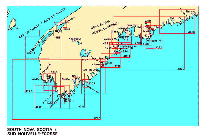
Navigation Bar Checkout View Cart E-mail Us Maps Publications Search Home

Nautical Charts for South Nova Scotia

Looking for nautical charts for South Nova Scotia? See below for an index to charts produced by Canadian Hydrographic Service - detailed information is available by clicking on an area of the map.

If you do not see what you are looking for, please feel free to ask us.
Charts of South Nova Scotia Liverpool Harbour LaHave River, Conquerall Bank to Bridgewater Lunenburg Bay LaHave River, West Ironbound Island to/à Riverport LaHave River, Riverport to/à Conquerall Bank Pearl Island to Cape La Have Cape LaHave to/à Liverpool Bay Halifax Harbour - Bedford Basin Halifax Harbour - Point Pleasant to/à Bedford Basin Halifax Harbour - Black Point to/à Point Pleasant Approaches to/approches au Halifax Harbour Chebucto Head to/à Betty Island St. Margaret's Bay Mahone Bay Lockeport Harbour Liverpool Harbour to/à Lockeport Harbour Shelburne Harbour Cape Sable to/à Pubnico Harbour Yarmouth Harbour and Approaches/et les approches Wedgeport and Vicinity/et les abords Lockeport to/à Cape Sable Cape Sable Island to/aux Tusket Islands Tusket Islands to/au Cape St. Marys Kejimkujik Lake Annapolis Basin St. Marys Bay Little Hope Island to/à Cape St Marys Taylors Head to/à Shut-in Island Egg Island to West Ironbound Island

Please Note:
  • Charts are normally sent rolled in a tube for orders shipped within Canada and the United States. Charts sent to other countries are sent folded. If you would prefer to make alternate arrangements, please specify at the time of ordering. Charts sent rolled in a tube to the U.S. by mail usually take longer to arrive than folded orders.
  • Some charts are only available pre-folded, as indicated beside the chart title. These charts are only available folded, not rolled.
  • All charts are on paper, and not available in waterproof unless indicated.
Chart Number Name Scale Price  
4118 St. Marys Bay
-Petit Passage
-Weymouth
-Grand Passage
-East Sandy Cove
-Meteghan
1:60 000
1:30 000
1:30 000
1:30 000
1:20 000
1:3 000
$20.00 Add to Cart
4201 Halifax Harbour - Bedford Basin 1:10 000 $20.00 Add to Cart
4202 Halifax Harbour - Point Pleasant to/à Bedford Basin
-Ocean Terminals
1:10 000
1:5 000
$20.00 Add to Cart
4203 Halifax Harbour - Black Point to/à Point Pleasant 1:10 000 $20.00 Add to Cart
4209 Lockeport Harbour and/et Shelburne Harbour
-Lockeport
-Shelburne
1:20 000
1:5 000
1:10 000
$20.00 Add to Cart
4210 Cape Sable to/à Pubnico Harbour 1:30 000 $20.00 Add to Cart
4211 Cape LaHave to/à Liverpool Bay 1:37 500 $20.00 Add to Cart
4230 Little Hope Island to/à Cape St Marys 1:150 000 $20.00 Add to Cart
4236 Taylors Head to/à Shut-in Island
-Ship Harbour and Approaches/et les approches
1:60 000
1:30 000
$20.00 Add to Cart
4237 Approaches to/approches au Halifax Harbour
-Sambro Harbour
1:40 000
1:20 000
$20.00 Add to Cart
4240 Liverpool Harbour to/à Lockeport Harbour
-Sambro Harbour
1:60 000
1:6 000
$20.00 Add to Cart
4241 Lockeport to/à Cape Sable 1:60 000 $20.00 Add to Cart
4242 Cape Sable Island to/aux Tusket Islands 1:60 000 $20.00 Add to Cart
4243 Tusket Islands to/au Cape St. Marys
-Cape St. Marys
1:60 000
1:5 000
$20.00 Add to Cart
4244 Wedgeport and Vicinity/et les abords 1:30 000 $20.00 Add to Cart
4245 Yarmouth Harbour and Approaches/et les approches
-Yarmouth Wharves/Quais
1:10 000
1:5 000
$20.00 Add to Cart
4320 Egg Island to West Ironbound Island 1:145 000 $20.00 Add to Cart
4328 Lunenburg Bay
-Lunenburg Harbour
1:18 000
1:9 000
$20.00 Add to Cart
4379 Liverpool Harbour 1:8 400 $20.00 Add to Cart
4381 Mahone Bay
-Mahone Harbour
-Chester Harbour
1:38 900
1:13 700
1:12 100
$20.00 Add to Cart
4384 Pearl Island to Cape La Have 1:39 000 $20.00 Add to Cart
4385 Chebucto Head to/à Betty Island 1:39 000 $15.00 Add to Cart
4386 St. Margaret's Bay
-Head Harbour
-Hubbards Cove
1:39 400
1:22 000
1:22 000
$20.00 Add to Cart
4391 LaHave River, Conquerall Bank to Bridgewater
-Bridgewater Public Wharf
1:6 000
1:1 200
$20.00 Add to Cart
4394 LaHave River, West Ironbound Island to/à Riverport 1:12 200 $20.00 Add to Cart
4395 LaHave River, Riverport to/à Conquerall Bank
-Kraut Point
-LaHave
-Riverport
1:12 200
1:2 400
1:2 400
1:1 200
$20.00 Add to Cart
4396 Annapolis Basin
-Digby
-Marine Atlantic Terminal/Terminal de Marine Atlantiqu
1:24 000
1:5 400
1:5 000
$20.00 Add to Cart
6730 Kejimkujik Lake 1:12 000 $20.00 Add to Cart
Price and availability subject to change. Shipping and applicable taxes extra.
Questions about anything on this page? Please e-mail us.
This page last modified: February 12, 2003

Index: Atlantic Coast
What's New · Home · Search · Books on Canada · Canadian Maps and Charts · Ordering · E-mail Us

©Federal Publications Inc., 1998 - 2008
165 University Avenue, Toronto, Ontario, Canada M5H 3B8
Phone: (416) 860-1611 or toll-free 1-888-433-3782 · E-mail: info@fedpubs.com