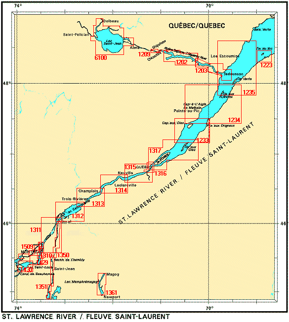
Federal Publications logo FEDERAL
PUBLICATIONS
INC.

Navigation Bar Checkout View Cart Contact Us Canadian Maps and Charts Books on Canada Home

Nautical Charts for St. Lawrence, east of Montreal

For information on charts for the for the St. Lawrence east of Montreal produced by Canadian Hydrographic Service, click an area of the index below, or see our price list to order.

Digital Charts on CD-ROM are also available for this region.

If you do not see what you are looking for, please feel free to ask us.
Please Note:
  • Charts are normally sent rolled in a tube for orders shipped within Canada and the United States. Charts sent to other countries are sent folded. If you would prefer to make alternate arrangements, please specify at the time of ordering. Charts sent rolled in a tube to the U.S. by mail usually take longer to arrive than folded orders.
  • Some charts are only available pre-folded, as indicated beside the chart title.
  • All charts are printed on paper and are not available in waterproof unless indicated.

 
St. Laurence area east of Montreal Sorel a Varennes Port de Montréal Canal de la Rive Sud Lac Saint - Louis Lac Memphrémagog Rivière Richelieu, Bassin de Chambly au/to Lac Champlain Rivière Richelieu, Sorel à/to Otterburn-Park Rivière des Prairies Lac Saint Pierre Batiscan au/to Lac Saint Pierre Donnacona à/to Batiscan Quebec à/to Donnacona Port de Québec Sault-au-Cochon à/to Québec Cap aux Oies à/to Sault-au-Cochon Cap de la Tête au Chien à/to Cap aux Oies Île du Bic au/to Cap de la Tête au Chien Chenal du Bic et les approches/ and approaches Rivière Saguenay / Saguenay River, Tadoussac à/to Saint-Fulgence Rivière Saguenay, Cap Éternité à/to Saint-Fulgence Rivière Saguenay/Saguenay River, Saint-Fulgence à/to Rivière Shipshaw Lac Saint-Jean
Chart Number Name Scale Price  
1202 Rivière Saguenay/Saguenay River, Cap Éternité à/to Saint-Fulgence
-Baie des Ha! Ha!
1:37 500
1:24 600
$20.00 Add to Cart
1203 Rivière Saguenay/Saguenay River, Tadoussac à/to Cap Éternité
-Tadoussace
1:24 600
1:5 000
$20.00 Add to Cart
1209 Rivière Saguenay/Saguenay River, Saint-Fulgence à/to Rivière Shipshaw 1:18 000 $20.00 Add to Cart
1223 Chenal du Bic et les approches/and approaches 1:24 000 $20.00 Add to Cart
1233 Cap aux Oies à/to Sault-au-Cochon
-Saint-Joseph-de-la-Rive
-Île aux Coudres
-Saint-Jean-Port-Joli
1:50 000
1:5 000
1:5 000
1:5 000
$20.00 Add to Cart
1234 Cap de la Tête au Chien à/to Cap aux Oies
-Port de Gros-Cacouna
-Pointe de la Rivière du Loup
-Pointe-au-Pic
-Saint-Siméon
-Cap À L'Aigle
1:80 000
1:10 000
1:5 000
1:5 000
1:5 000
1:5 000
$20.00 Add to Cart
1310 Port de Montréal
-Quai Alexandra
1:15 000
1:10 000
$20.00 Add to Cart
1311 Sorel à/to Varennes
-Terminal Contrecoeur
1:40 000
1:10 000
$20.00 Add to Cart
1312 Lac Saint-Pierre
-Port de Sorel
1:40 000
1:10 000
$20.00 Add to Cart
1313 Batiscan au/to Lac Saint-Pierre
-Port de Bécancour
-Port de Trois-Rivières
1:40 000
1:15 000
1:15 000
$20.00 Add to Cart
1314 Donnacona à/to Batiscan
-Batiscan
-Portneuf
1:40 000
1:5 000
1:5 000
$20.00 Add to Cart
1315 Québec à/to Donnacona 1:40 000 $20.00 Add to Cart
1316 Port de Québec 1:15 000 $20.00 Add to Cart
1317 Sault-au-Cochon à/to Québec 1:50 000 $20.00 Add to Cart
1320 Île du Bic au/to Cap de la Tête au Chien 1:80 000 $20.00 Add to Cart
1350 Rivière Richelieu, Sorel à/to Otterburn-Park
-pre-folded
2007 Edition
1:15 000 $28.00 Add to Cart
1351 Rivière Richelieu, Bassin de Chambly au Lac/to Lake Champlain
-pre-folded
2007 Edition
1:15 000 $28.00 Add to Cart
1361 Lac Memphrémagog 1:31 700 $20.00 Add to Cart
1429 Canal de la Rive Sud 1:20 000 $20.00 Add to Cart
1430 Lac Saint-Louis
-Union Carbide
1:25 000
1:6 000
$20.00 Add to Cart
1509 Rivière des Prairies 1:20 000 $18.00 Add to Cart
6100 Lac Saint-Jean 1:120 000 $28.00 Add to Cart

Related Sections:
  Atlantic Chart Index
  General Atlantic Charts
  Coastal Atlantic Charts
  Anticosti Island Charts
  Avalon Peninsula Charts
  Bay of Fundy Charts
  Cape Breton Island Charts
  Central Nfld Charts
  Central Nova Scotia Charts
  Chaleur Bay Charts
  Northern Nfld Charts
  Hudson Strait Charts
  Labrador Sea Charts
  Prince Edward Island Charts
  Southern Nova Scotia Charts
  Southern Nfld Charts
  St. Lawrence Charts
  Charts on CD-ROM

Browse By Type of Map:
  Topographic Maps
  Nautical Charts
  Aeronautical Charts
  Depth Maps and Charts
  Recreation Maps
  Park Maps
  Backroad Mapbooks
  Digital Topographic Maps

Browse By Region:
  Canada
  Alberta
  British Columbia
  Manitoba
  New Brunswick
  Newfoundland
  Northwest Territories
  Nova Scotia
  Nunavut
  Ontario
  Prince Edward Island
  Quebec
  Saskatchewan
  Yukon
Featured Areas:
  Algonquin
  Killarney
  Temagami
  Banff
  Jasper
Outside Canada:
  Maps of the World
  North America

Related Reading:
  Boating in Canada
  Sailing Directions
  List of Lights
  Radio Aids
  Tide and Current Tables
Price and availability subject to change. Shipping and applicable taxes extra.

Can't find what you're looking for? Try the search button at the top of the page.
Questions about anything on this page? Please e-mail us.

Information on this page last updated: Apri 26, 2012

What's New · Home · Search · Books on Canada · Canadian Maps and Charts · Ordering · Contact Us
©Federal Publications Inc., 1998 - 2016
425 University Avenue, Ste. 401, Toronto, Ontario, Canada M5G 1T6
Phone: (416) 860-1611 or toll-free 1-888-433-3782 · E-mail: info@fedpubs.com