| |
Topographic Maps for
Jasper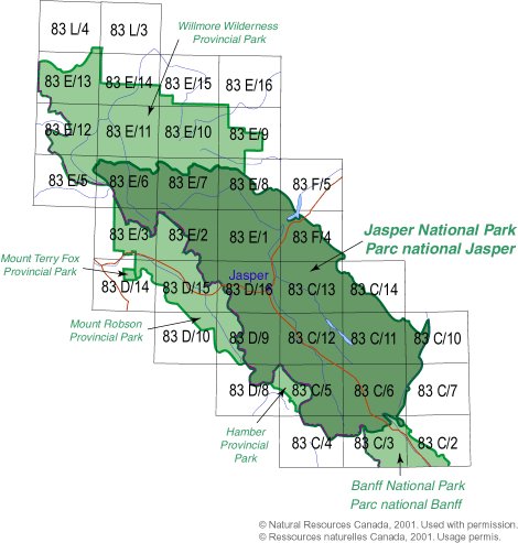
This index shows the topographic maps available for Jasper
National Park. Each map (e.g. 83C/13) covers an area approximately 40km by 28
km (scale 1:50,000).
- Paper maps and Waterpoof maps are normally sent
pre-folded. If you would prefer that we send them rolled in a tube, please
specify in the Special Handling Instructions field on our Shipping Information
page during checkout.
- Tyvek maps are only
available pre-folded and stock is limited.
- Topographic maps show the detail of the land and its
surface features. They do not show water depths.
|
| Map Number |
Scale |
Name |
Paper
$12.45 |
Waterproof
$17.95 |
Tyvek®
$11.45
|
| 083C02 |
1:50,000 |
Cline River |
|
|
Not Available |
| 083C03 |
1:50,000 |
Columbia Icefield |
|
|
Not Available |
| 083C04 |
1:50,000 |
Clemenceau Icefield |
|
|
Not Available |
| 083C05 |
1:50,000 |
Fortress Lake |
|
|
Not Available |
| 083C06 |
1:50,000 |
Sunwapta Peak |
|
|
Not Available |
| 083C07 |
1:50,000 |
Job Creek |
|
|
Not Available |
| 083C10 |
1:50,000 |
George Creek |
|
|
Not Available |
| 083C11 |
1:50,000 |
Southesk Lake |
|
|
Not Available |
| 083C12 |
1:50,000 |
Athabasca Falls |
|
|
Not Available |
| 083C13 |
1:50,000 |
Medicine Lake |
|
|
Not Available |
| 083C14 |
1:50,000 |
Mountain Park |
|
|
Not Available |
| 083D08 |
1:50,000 |
Athabasca Pass |
|
|
Not Available |
| 083D09 |
1:50,000 |
Amethyst Lakes |
|
|
|
| 083D10 |
1:50,000 |
Ptarmigan Creek |
|
|
Not Available |
| 083D14 |
1:50,000 |
Valemount |
|
|
Not Available |
| 083D15 |
1:50,000 |
Lucerne |
|
|
Not Available |
| 083D16 |
1:50,000 |
Jasper |
|
|
|
| 083E01 |
1:50,000 |
Snaring River |
|
|
Not Available |
| 083E02 |
1:50,000 |
Resplendent Creek |
|
|
Not Available |
| 083E03 |
1:50,000 |
Mount Robson |
|
|
Not Available |
| 083E05 |
1:50,000 |
Chalco Mountain |
|
|
Not Available |
| 083E06 |
1:50,000 |
Twintree Lake |
|
|
Not Available |
| 083E07 |
1:50,000 |
Blue Creek |
|
|
Not Available |
| 083E08 |
1:50,000 |
Rock Lake |
|
|
Not Available |
| 083E09 |
1:50,000 |
Moberly Creek |
|
|
Not Available |
| 083E10 |
1:50,000 |
Adams Lookout |
|
|
Not Available |
| 083E11 |
1:50,000 |
Hardscrabble Creek |
|
|
Not Available |
| 083E12 |
1:50,000 |
Pauline Creek |
|
|
Not Available |
| 083E13 |
1:50,000 |
Dry Canyon |
|
|
Not Available |
| 083E14 |
1:50,000 |
Grande Cache |
|
|
Not Available |
| 083E15 |
1:50,000 |
Pierre Greys Lakes |
|
|
Not Available |
| 083E16 |
1:50,000 |
Donald Flats |
|
|
Not Available |
| 083F04 |
1:50,000 |
Miette |
|
|
Not Available |
| 083F05 |
1:50,000 |
Entrance |
|
|
Not Available |
| 083L03 |
1:50,000 |
Copton Creek |
|
|
Not Available |
| 083L04 |
1:50,000 |
Kakwa Falls |
|
|
Not Available |
Not sure which map covers the exact
place you're looking for?
Ask us or
try the
online
"search by map number, place name, or coordinates" website.
Other Maps of Jasper National
ParkKootenay National
Park - The Rockwall $10.95
Lake O'Hara - Yoho National Park
$8.95
We also carry some useful publications
about enjoying Jasper National ParkFrommer's Banff & Jasper
National Parks, 3rd Edition on sale
$11.99
|
|