Federal Publications logo FEDERAL
PUBLICATIONS
INC.
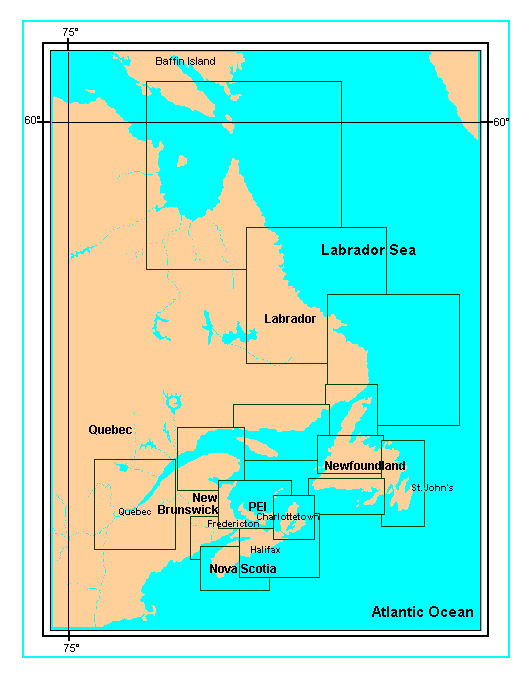
Navigation Bar Checkout View Cart Contact Us Canadian Maps and Charts Books on Canada Home

Nautical Charts: Atlantic Coast

Looking for nautical charts of the Atlantic Coast of Canada? See below for an index to charts produced by Canadian Hydrographic Service - detailed information is available by scrolling down and clicking on an area of the map. Or complete a request if you would like us to send you a paper index.

Digital Charts on CD-ROM are also available for this region.

If you do not see what you are looking for, please feel free to ask us.

 
Marine Charts: Atlantic Coast Charts for Cape Breton Island Charts for Prince Edward Island and Īles de la Madeleine Charts for South Newfoundland Nautical Charts for Central Nova Scotia and Sable Island Charts for Newfoundland and the Strait of Belle Isle Bonavista Bay, Trinity Bay, Avalon Peninsula and Placentia Bay Central Newfoundland Charts for the Bay of Fundy Charts for South Nova Scotia Charts for the Strait of Belle Isle and the East Coast of Labrador Charts for the Labrador Sea Nautical Charts for Hudson Strait and Labrador Sea North Shore and Anticosti Island St. Lawrence and Chaleur Bay St. Lawrence east of Montreal
In addition to the more detailed charts indexed above, there are less detailed charts covering larger areas of Atlantic Canada:

General Charts and Coastal Charts


Related Sections:
  Atlantic Chart Index
  General Atlantic Charts
  Coastal Atlantic Charts
  Anticosti Island Charts
  Avalon Peninsula Charts
  Bay of Fundy Charts
  Cape Breton Island Charts
  Central Nfld Charts
  Central Nova Scotia Charts
  Chaleur Bay Charts
  Northern Nfld Charts
  Hudson Strait Charts
  Labrador Sea Charts
  Prince Edward Island Charts
  Southern Nova Scotia Charts
  Southern Nfld Charts
  St. Lawrence Charts
  Charts on CD-ROM

Browse By Type of Map:
  Topographic Maps
  Nautical Charts
  Aeronautical Charts
  Depth Maps and Charts
  Recreation Maps
  Park Maps
  Backroad Mapbooks
  Digital Topographic Maps

Browse By Region:
  Canada
  Alberta
  British Columbia
  Manitoba
  New Brunswick
  Newfoundland
  Northwest Territories
  Nova Scotia
  Nunavut
  Ontario
  Prince Edward Island
  Quebec
  Saskatchewan
  Yukon
Featured Areas:
  Algonquin
  Killarney
  Temagami
  Banff
  Jasper
Outside Canada:
  Maps of the World
  North America

Related Reading:
  Boating in Canada
  Sailing Directions
  List of Lights
  Radio Aids
  Tide and Current Tables
Price and availability subject to change. Shipping and applicable taxes extra.

Can't find what you're looking for? Try the search button at the top of the page.
Questions about anything on this page? Please e-mail us.

Information on this page last updated: March 13, 2012

What's New · Home · Search · Books on Canada · Canadian Maps and Charts · Ordering · Contact Us
©Federal Publications Inc., 1998 - 2016
425 University Avenue, Ste. 401, Toronto, Ontario, Canada M5G 1T6
Phone: (416) 860-1611 or toll-free 1-888-433-3782 · E-mail: info@fedpubs.com