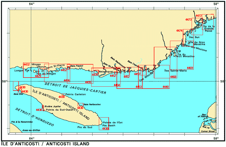
Federal Publications logo FEDERAL
PUBLICATIONS
INC.

Navigation Bar Checkout View Cart Contact Us Canadian Maps and Charts Books on Canada Home

Nautical Charts for Anticosti Island and the North Shore of the St. Lawrence

For information on charts for Anticosti Island and the North Shore of the St. Lawrence produced by Canadian Hydrographic Service, click an area of the index below, or see our price list to order.

Digital Charts on CD-ROM are also available for this region.

If you do not see what you are looking for, please feel free to ask us.
Please Note:
  • Charts are normally sent rolled in a tube for orders shipped within Canada and the United States. Charts sent to other countries are sent folded. If you would prefer to make alternate arrangements, please specify at the time of ordering. Charts sent rolled in a tube to the U.S. by mail usually take longer to arrive than folded orders.
  • Some charts are only available pre-folded, as indicated beside the chart title.
  • All charts are printed on paper and are not available in waterproof unless indicated.

  Cartes marines: Ile d'Anticosti Chart #4440 Îles Sainte-Marie to Île à la Brume Plans - Ile D'Anticosti Plans - Ile D'Anticosti Plans - Ile D'Anticosti Plans - Ile D'Anticosti Plans - Ile D'Anticosti Plans - Ile D'Anticosti Havres et Mouillages-Côte Nord / Harbours and Anchorages - North Shore Havres et Mouillages-Côte Nord / Harbours and Anchorages - North Shore Havres et Mouillages-Côte Nord / Harbours and Anchorages - North Shore Havre de Natashquan et les approches / and Approches Havre Saint-Pierre et les approches / and Approaches Iles de Mingan Baie Piashti à / to Petite Ile au Marteau Baie Washtawouka à / to Baie Piashti Pointe Curlew à / to Baie Washtawouka Ile à la Brume à / to Pointe Curlew Ile de Petit Mecatina aux / to Iles Sainte-Marie Ile Plate a / to Ile du Petit Mécatina Iles Bun à / to Baie des Moutons Ile de la Grande Passe aux / to Iles Bun Baie des Homards a/ to Ile de la Grande Passe
Chart Number Name Scale Price  
4428 Havre de Natashquan and Approaches 1:10 000 $20.00 Add to Cart
4429 Havre Saint-Pierre and Approaches
-Havre-Saint-Pierre
1:20 000
1:6 000
$20.00 Add to Cart
4430 Plans - Île D'Anticosti
-Pointe de l'Est
-Baie Natiscotec
-Pointe Carleton
-Pointe du Sud-Ouest
-Rivière Jupiter
-Baie Ellis
-Pointe de l'Ouest

1:72 000
1:72 100
1:23 800
1:23 800
1:12 000
1:48 000
1:48 000
$20.00 Add to Cart
4432 Îles de Mingan
-Havre de Mingan
1:69 700
1:24 000
$20.00 Add to Cart
4440 Îles Sainte-Marie to Île à la Brume 1:73 700 $20.00 Add to Cart
4452 Havres et Mouillages-Côte Nord / Harbours and Anchorages - North Shore
-Baie Johan-Beetz and Baie Piashti
-Havre Gethsémani
-Baie Washicoutai

-Baie Coacoachou
-Baie Kégashka

1:12 000
1:10 000
1:48 000
1:48 000
1:24 000
$20.00 Add to Cart
4453 Île à la Brume to Pointe Curlew 1:70 100 $20.00 Add to Cart
4454 Pointe Curlew to Baie Washtawouka 1:70 000 $20.00 Add to Cart
4455 Baie Washtawouka to Baie Piashti 1:70 000 $20.00 Add to Cart
4456 Baie Piashti to Petite Île au Marteau 1:70 000 $20.00 Add to Cart
4468 Île de Petit Mecatina to Îles Sainte-Marie
-Havre de Harrington
1:75 200
1:24 000
$20.00 Add to Cart
4469 Île Plate to Île du Petit Mécatina 1:76 300 $20.00 Add to Cart
4472 Baie des Homards to Île de la Grande Passe 1:36 600 $20.00 Add to Cart
4473 Île de la Grande Passe to Îles Bun 1:36 600 $20.00 Add to Cart
4474 Îles Bun to Baie des Moutons 1:36 500 $20.00 Add to Cart

Related Sections:
  Atlantic Chart Index
  General Atlantic Charts
  Coastal Atlantic Charts
  Anticosti Island Charts
  Avalon Peninsula Charts
  Bay of Fundy Charts
  Cape Breton Island Charts
  Central Nfld Charts
  Central Nova Scotia Charts
  Chaleur Bay Charts
  Northern Nfld Charts
  Hudson Strait Charts
  Labrador Sea Charts
  Prince Edward Island Charts
  Southern Nova Scotia Charts
  Southern Nfld Charts
  St. Lawrence Charts
  Charts on CD-ROM

Browse By Type of Map:
  Topographic Maps
  Nautical Charts
  Aeronautical Charts
  Depth Maps and Charts
  Recreation Maps
  Park Maps
  Backroad Mapbooks
  Digital Topographic Maps

Browse By Region:
  Canada
  Alberta
  British Columbia
  Manitoba
  New Brunswick
  Newfoundland
  Northwest Territories
  Nova Scotia
  Nunavut
  Ontario
  Prince Edward Island
  Quebec
  Saskatchewan
  Yukon
Featured Areas:
  Algonquin
  Killarney
  Temagami
  Banff
  Jasper
Outside Canada:
  Maps of the World
  North America

Related Reading:
  Boating in Canada
  Sailing Directions
  List of Lights
  Radio Aids
  Tide and Current Tables
Price and availability subject to change. Shipping and applicable taxes extra.

Can't find what you're looking for? Try the search button at the top of the page.
Questions about anything on this page? Please e-mail us.

Information on this page last updated: April 26, 2012

What's New · Home · Search · Books on Canada · Canadian Maps and Charts · Ordering · Contact Us
©Federal Publications Inc., 1998 - 2016
425 University Avenue, Ste. 401, Toronto, Ontario, Canada M5G 1T6
Phone: (416) 860-1611 or toll-free 1-888-433-3782 · E-mail: info@fedpubs.com