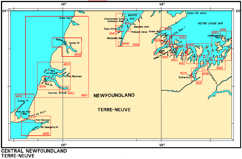
Federal Publications logo FEDERAL
PUBLICATIONS
INC.

Navigation Bar Checkout View Cart Contact Us Canadian Maps and Charts Books on Canada Home

Nautical Charts for Central Newfoundland

Looking for nautical charts of Central Newfoundland? See below for an index to charts produced by Canadian Hydrographic Service - detailed information is available by scrolling down and clicking on an area of the map.

Digital Charts on CD-ROM are also available for this region.

If you do not see what you are looking for, please feel free to ask us.
Please Note:
  • Charts are normally sent rolled in a tube for orders shipped within Canada and the United States. Charts sent to other countries are sent folded. If you would prefer to make alternate arrangements, please specify at the time of ordering. Charts sent rolled in a tube to the U.S. by mail usually take longer to arrive than folded orders.
  • Some charts are only available pre-folded, as indicated beside the chart title. These charts are only available folded, not rolled.
  • All charts are on paper, and not available in waterproof unless indicated.

 
Nautical Charts of Central Newfoundland Twillingate Harbour Port Harmon Approaches to Lewisporte Bacalhao Island to Black Island Port au Port Bear Head to Cow Head Bonne Bay Bay of Islands Lark and York Harbours Humber Arm Botwood Harbour Bay of Exploits Bay of Exploits Sunday Cove Island to Thimble Tickles Little Bay Island to League Rock Halls Bay and Sunday Cove Green Head to Little Bay White Bay (Southern Plans in Notre Dame Bay Plans in Notre Dame Bay Hampden Bay Sops Arm Purbeck Cove Jacksons Arm Frenchmans Cove Little Bay Arm
Chart Number Name Scale Price  
4523 Little Bay Arm and Approaches, Beaver Cove Head to Goudies Cove
-Goudies Cove
-Otter Island Narrows
1:6 000
1:3 000
1:3 000
$20.00 Add to Cart
4524 Botwood Harbour
-Botwood Wharves
1:9 000
1:4 500
$20.00 Add to Cart
4540 Anchorages in White Bay
-Frenchmans Cove
-Purbeck Cove
-Jacksons Arm
  $15.00 Add to Cart
4541 Sops Arm   $15.00 Add to Cart
4542 Hampden Bay 1:12 200 $15.00 Add to Cart
4582 Plans in Notre Dame Bay
-Thimble Tickles and Glover Harbour
-Head of Seal Bay
1:12 200
1:24 300
$15.00 Add to Cart
4584 White Bay (Southern Part) 1:73 500 $15.00 Add to Cart
4585 Green Head to Little Bay Island   $20.00 Add to Cart
4591 Halls Bay and Sunday Cove
-Springdale Public Wharf
-Pilley's Island Harbour
1:37 400
1:3 000
1:10 600
$20.00 Add to Cart
4592 Little Bay Island to League Rock 1:24 400 $20.00 Add to Cart
4593 Sunday Cove Island to Thimble Tickles 1:24 500 $20.00 Add to Cart
4596 Bay of Exploits - Sheet II (Middle) 1:24 600 $20.00 Add to Cart
4597 Bay of Exploits - Sheet III (South) 1:24 600 $20.00 Add to Cart
4652 Humber Arm, Meadows Point to Humber River
-Corner Brook
1:14 600
1:7 200
$20.00 Add to Cart
4653 Bay of Islands
-The Narrows
-Little Port
1:50 000
1:6 000
1:6 000
$20.00 Add to Cart
4654 Lark and York Harbours (Bay of Islands) 1:12 000 $20.00 Add to Cart
4658 Bonne Bay
-Rocky Harbour

-Woody Point, Neddy Harbour and Approaches
1:40 000
1:15 000
1:15 000
$20.00 Add to Cart
4659 Port au Port   $20.00 Add to Cart
4661 Bear Head to Cow Head
-Green Cove
-Trout River Bay
1:36 500
1:36 500
$20.00 Add to Cart
4863 Bacalhao Island to Black Island 1:40 000 $20.00 Add to Cart
4864 Black Island to Little Denier Island 1:40 000 $20.00 Add to Cart
4865 Approaches to Lewisporte and Loon Bay
-Lewisporte
1:30 000
1:5 000
$20.00 Add to Cart
4885 Port Harmon and Approaches
-Port Harmon
-Flintkote Wharf
-St. George's Public Wharf
1:40 000
1:6 000
1:4 000
1:2 500
$20.00 Add to Cart
4886 Twillingate Harbour
-Twillingate Government Wharf
-Twillingate Fish Harbour Wharf
1:15 000
1:5 000
1:5 000
$15.00 Add to Cart

Related Sections:
  Atlantic Chart Index
  General Atlantic Charts
  Coastal Atlantic Charts
  Anticosti Island Charts
  Avalon Peninsula Charts
  Bay of Fundy Charts
  Cape Breton Island Charts
  Central Nfld Charts
  Central Nova Scotia Charts
  Chaleur Bay Charts
  Northern Nfld Charts
  Hudson Strait Charts
  Labrador Sea Charts
  Prince Edward Island Charts
  Southern Nova Scotia Charts
  Southern Nfld Charts
  St. Lawrence Charts
  Charts on CD-ROM

Browse By Type of Map:
  Topographic Maps
  Nautical Charts
  Aeronautical Charts
  Depth Maps and Charts
  Recreation Maps
  Park Maps
  Backroad Mapbooks
  Digital Topographic Maps

Browse By Region:
  Canada
  Alberta
  British Columbia
  Manitoba
  New Brunswick
  Newfoundland
  Northwest Territories
  Nova Scotia
  Nunavut
  Ontario
  Prince Edward Island
  Quebec
  Saskatchewan
  Yukon
Featured Areas:
  Algonquin
  Killarney
  Temagami
  Banff
  Jasper
Outside Canada:
  Maps of the World
  North America

Related Reading:
  Boating in Canada
  Sailing Directions
  List of Lights
  Radio Aids
  Tide and Current Tables
Price and availability subject to change. Shipping and applicable taxes extra.

Can't find what you're looking for? Try the search button at the top of the page.
Questions about anything on this page? Please e-mail us.

Information on this page last updated: March 13, 2012

What's New · Home · Search · Books on Canada · Canadian Maps and Charts · Ordering · Contact Us
©Federal Publications Inc., 1998 - 2016
425 University Avenue, Ste. 401, Toronto, Ontario, Canada M5G 1T6
Phone: (416) 860-1611 or toll-free 1-888-433-3782 · E-mail: info@fedpubs.com