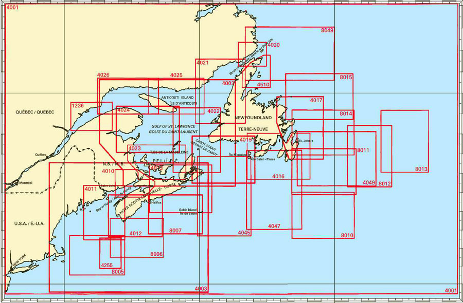
Federal Publications logo FEDERAL
PUBLICATIONS
INC.

Navigation Bar Checkout View Cart Contact Us Canadian Maps and Charts Books on Canada Home

Coastal Charts for Atlantic Canada

Looking for general nautical charts of Atlantic Canada? See below for an index to charts produced by Canadian Hydrographic Service - order information appears below the map.

Digital Charts on CD-ROM are also available for this region.

If you do not see what you are looking for, please feel free to ask us.
Please Note:
  • Charts are normally sent rolled in a tube for orders shipped within Canada and the United States. Charts sent to other countries are sent folded. If you would prefer to make alternate arrangements, please specify at the time of ordering. Charts sent rolled in a tube to the U.S. by mail usually take longer to arrive than folded orders.
  • Some charts are only available pre-folded, as indicated beside the chart title. These charts are only available folded, not rolled.
  • All charts are on paper, and not available in waterproof unless indicated.

 
Coastal Charts for Atlantic Canada Cape Freels to/à Exploits Islands White Bay and/et Notre Dame Bay Cape St. John to/à St. Anthony Chart #8014 Grand Banc, Northeast Portion Chart #4017 Cape Race to Capre Freels Chart #4010 Bay of Fundy (inner portion) Chart #4012 Yarmouth to Halifax Chart #4011 Approaches to Bay of Fundy Chart #4013 Halifax to Sydney Chart #4023 Northumberland Strait Chart #4022 Cabot Strait and Approaches Chart #4015 Sydney to Saint-Pierre Chart #4049 Grand Bank, Northern Portion Chart #8012 Flemish Pass Chart #4016 Saint-Pierre to St. John's Chart #8007 Halifax to Sable Island Chart #8006 Scotian Shelf, Browns Bank to Emerald Bank Chart #4255 Georges Bank Eastern Portion Chart #8005 Georges Bank Chart #4024 Baie des Chaleurs to Îles de la Madeleine Chart #4025 Cap Whittle to Havre-Saint-Pierre and Île d'Anticosti Chart #4026 Havre-Saint-Pierre and Cap des Rosiers to Pointe des Monts Chart #4002  Gulf of St. Lawrence Chart #4012 Pointe Amour to Cape Whittle and Cape St. George Chart #4020 Strait of Belle Isle Chart #8015 Sydney to Saint-Pierre Chart #4001 Gulf of Maine to Strait of Belle Isle Chart #4003 Cape Breton to Cape Cod Chart #4045 Sable Island Bank to St. Pierre Bank Chart #4047 St. Pierre Bank to Whale Bank Chart #8049 St. Michael Bay to Gray Islands Chart #8010 Grand Bank, Southern Portion Chart #8013 Flemish Cap Chart #1236 Pointe des Monts to Escoumins
Chart Number Name Scale Price  
1236 Pointe des Monts to Escoumins
-Rimouski, Pointe au Père
-Matane
-Baie Verte
-Godbout
1:200 000
1:20 000
1:20 000
1:20 000
1:5 000
$20.00 Add to Cart
4001 Gulf of Maine to Strait of Belle Isle, including Gulf of St. Lawrence 1:3 500 000 $20.00 Add to Cart
4002 Gulf of St. Lawrence 1:750 000 $20.00 Add to Cart
4003 Cape Breton to Cape Cod 1:1 000 000 $20.00 Add to Cart
4010 Bay of Fundy (inner portion) 1:200 000 $20.00 Add to Cart
4011 Approaches to Bay of Fundy 1:300 000 $20.00 Add to Cart
4012 Yarmouth to Halifax 1:300 000 $20.00 Add to Cart
4013 Halifax to Sydney 1:350 000 $20.00 Add to Cart
4015 Sydney to Saint-Pierre 1:350 000 $20.00 Add to Cart
4016 Saint-Pierre to St. John's 1:350 000 $20.00 Add to Cart
4017 Cape Race to Capre Freels 1:350 000 $20.00 Add to Cart
4020 Strait of Belle Isle 1:150 000 $20.00 Add to Cart
4021 Pointe Amour to Cape Whittle and Cape St. George
-Lower Cove
1:350 000
1:15 000
$20.00 Add to Cart
4022 Cabot Strait and Approaches, Scatarie Island to Anticosti Island 1:350 000 $20.00 Add to Cart
4023 Northumberland Strait 1:300 000 $20.00 Add to Cart
4024 Baie des Chaleurs to Îles de la Madeleine 1:350 000 $20.00 Add to Cart
4025 Cap Whittle to Havre-Saint-Pierre and Île d'Anticosti 1:300 000 $20.00 Add to Cart
4026 Havre-Saint-Pierre and Cap des Rosiers to Pointe des Monts 1:300 000 $20.00 Add to Cart
4045 Sable Island Bank to St. Pierre Bank 1:400 000 $20.00 Add to Cart
4047 St. Pierre Bank to Whale Bank 1:400 000 $20.00 Add to Cart
4049 Grand Bank, Northern Portion to la Flemish Pass 1:400 000 $20.00 Add to Cart
4255 Georges Bank Eastern Portion 1:175 000 $20.00 Add to Cart
4820 Cape Freels to Exploits Islands 1:150 000 $20.00 Add to Cart
4821 White Bay and Notre Dame Bay 1:150 000 $20.00 Add to Cart
4822 Cape St. John to St. Anthony 1:150 000 $20.00 Add to Cart
8005 Georges Bank 1:300 000 $20.00 Add to Cart
8006 Scotian Shelf, Browns Bank to Emerald Bank 1:300 000 $20.00 Add to Cart
8007 Halifax to Sable Island including Emerald Bank and Sable Island Bank 1:300 000 $20.00 Add to Cart
8010 Grand Bank, Southern Portion 1:350 000 $20.00 Add to Cart
8011 Grand Bank, Northern Portion 1:350 000 $20.00 Add to Cart
8012 Flemish Pass 1:350 000 $20.00 Add to Cart
8013 Flemish Cap 1:350 000 $20.00 Add to Cart
8014 Grand Banc, Northeast Portion 1:350 000 $20.00 Add to Cart
8015 Funk Island and Approaches 1:350 000 $20.00 Add to Cart
8049 St. Michael Bay to Gray Islands 1:500 000 $20.00 Add to Cart

Related Sections:
  Atlantic Chart Index
  General Atlantic Charts
  Coastal Atlantic Charts
  Anticosti Island Charts
  Avalon Peninsula Charts
  Bay of Fundy Charts
  Cape Breton Island Charts
  Central Nfld Charts
  Central Nova Scotia Charts
  Chaleur Bay Charts
  Northern Nfld Charts
  Hudson Strait Charts
  Labrador Sea Charts
  Prince Edward Island Charts
  Southern Nova Scotia Charts
  Southern Nfld Charts
  St. Lawrence Charts
  Charts on CD-ROM

Browse By Type of Map:
  Topographic Maps
  Nautical Charts
  Aeronautical Charts
  Depth Maps and Charts
  Recreation Maps
  Park Maps
  Backroad Mapbooks
  Digital Topographic Maps

Browse By Region:
  Canada
  Alberta
  British Columbia
  Manitoba
  New Brunswick
  Newfoundland
  Northwest Territories
  Nova Scotia
  Nunavut
  Ontario
  Prince Edward Island
  Quebec
  Saskatchewan
  Yukon
Featured Areas:
  Algonquin
  Killarney
  Temagami
  Banff
  Jasper
Outside Canada:
  Maps of the World
  North America

Related Reading:
  Boating in Canada
  Sailing Directions
  List of Lights
  Radio Aids
  Tide and Current Tables
Price and availability subject to change. Shipping and applicable taxes extra.

Can't find what you're looking for? Try the search button at the top of the page.
Questions about anything on this page? Please e-mail us.

Information on this page last updated: March 13, 2012

What's New · Home · Search · Books on Canada · Canadian Maps and Charts · Ordering · Contact Us
©Federal Publications Inc., 1998 - 2016
425 University Avenue, Ste. 401, Toronto, Ontario, Canada M5G 1T6
Phone: (416) 860-1611 or toll-free 1-888-433-3782 · E-mail: info@fedpubs.com