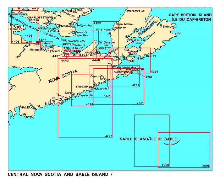
Federal Publications logo FEDERAL
PUBLICATIONS
INC.

Navigation Bar Checkout View Cart Contact Us Canadian Maps and Charts Books on Canada Home

Nautical Charts for Central Nova Scotia and Sable Island

For information on charts for Central Nova Scotia and Sable Island produced by Canadian Hydrographic Service, click an area of the index below, or see our price list to order.

Digital Charts on CD-ROM are also available for this region.

If you do not see what you are looking for, please feel free to ask us.
Please Note:
  • Charts are normally sent rolled in a tube for orders shipped within Canada and the United States. Charts sent to other countries are sent folded. If you would prefer to make alternate arrangements, please specify at the time of ordering. Charts sent rolled in a tube to the U.S. by mail usually take longer to arrive than folded orders.
  • Some charts are only available pre-folded, as indicated beside the chart title.
  • All charts are printed on paper and are not available in waterproof unless indicated.

 
Central Nova Scotia and Sable Island East River of Pictou, Indian Cross Point to Trenton and New Glasgow Pictou Harbour Merigomish Harbour Caribou Harbour Cape George to Pictou Wallace Harbour Amet Sound Pugwash Harbour and Approaches Tryon Shoals to Cape Egmont Antigonish Harbour Pomquet and Tracadie Harbours Canso Harbour to Strait of Canso Strait of Canso and Approaches St. George's Bay Cape Canso to/à Country Island Country Island to/à Barren Island Barren Island to/à Taylors Head Cape Canso to Liscomb Island Country Harbour to/au Ship Harbour Sable Island/Île de Sable Sable Island/Île de Sable, Western Part/Partie ouest
Chart Number Name Scale Price  
4098 Sable Island 1:100 000 $20.00 Add to Cart
4099 Sable Island, Western Part 1:100 000 $20.00 Add to Cart
4227 Country Harbour to Ship Harbour 1:150 000 $20.00 Add to Cart
4233 Cape Canso to Country Island
-Tor Bay
-Whitehead Harbour
1:60 000
1:30 000
1:30 000
$20.00 Add to Cart
4234 Country Island to Barren Island
-Country Harbour
-St Marys River
-Port Bickerton
1:60 000
1:30 000
1:30 000
1:20 000
$20.00 Add to Cart
4235 Barren Island to Taylors Head
-Ecum Secum
-Sheet Harbour
1:60 000
1:30 000
1:30 000
$20.00 Add to Cart
4244 Wedgeport and Vicinity 1:30 000 $20.00 Add to Cart
4281 Canso Harbour and Inner Approaches 1:15 000 $20.00 Add to Cart
4307 Canso Harbour to Strait of Canso 1:37 500 $20.00 Add to Cart
4321 Cape Canso to Liscomb Island 1:108 800 $20.00 Add to Cart
4335 Strait of Canso and Approaches 1:75 000 $20.00 Add to Cart
4402 Wallace Harbour 1:24 000 $15.00 Add to Cart
4403 East Point to Cape Bear 1:75 000 $20.00 Add to Cart
4404 Cape George to Pictou
-Baillie Brook Wharf
-Cribbean Head Wharf
-Ballantynes Cove Wharf
-Arisaig Harbour Wharf
1:76 000
1:2 400
1:2 400
1:2 400
1:2 400
$20.00 Add to Cart
4406 Tryon Shoals to Cape Egmont 1:75 600 $20.00 Add to Cart
4437 Pictou Harbour
-Pictou
1:12 000
1:3 600
$20.00 Add to Cart
4443 East River of Pictou, Indian Cross Point to Trenton and New Glasgow
-Trenton
-New Glasgow Wharf
1:7 200
1:2 400
1:2 400
$20.00 Add to Cart
4445 Merigomish Harbour 1:18 200 $20.00 Add to Cart
4446 Antigonish Harbour 1:12 000 $20.00 Add to Cart
4447 Pomquet and Tracadie Harbours 1:25 000 $20.00 Add to Cart
4462 St. George's Bay 1:75 200 $20.00 Add to Cart
4483 Caribou Harbour
-Caribou Ferry Terminal
-Wood Islands Ferry Terminal
1:18 000
1:2 400
1:2 400
$20.00 Add to Cart
4497 Amet Sound
-Malagash Wharf
1:28 900
1:3 600
$20.00 Add to Cart
4498 Pugwash Harbour and Approaches
-Pugwash Harbour
1:24 000
1:12 000
$20.00 Add to Cart

Related Sections:
  Atlantic Chart Index
  General Atlantic Charts
  Coastal Atlantic Charts
  Anticosti Island Charts
  Avalon Peninsula Charts
  Bay of Fundy Charts
  Cape Breton Island Charts
  Central Nfld Charts
  Central Nova Scotia Charts
  Chaleur Bay Charts
  Northern Nfld Charts
  Hudson Strait Charts
  Labrador Sea Charts
  Prince Edward Island Charts
  Southern Nova Scotia Charts
  Southern Nfld Charts
  St. Lawrence Charts
  Charts on CD-ROM

Browse By Type of Map:
  Topographic Maps
  Nautical Charts
  Aeronautical Charts
  Depth Maps and Charts
  Recreation Maps
  Park Maps
  Backroad Mapbooks
  Digital Topographic Maps

Browse By Region:
  Canada
  Alberta
  British Columbia
  Manitoba
  New Brunswick
  Newfoundland
  Northwest Territories
  Nova Scotia
  Nunavut
  Ontario
  Prince Edward Island
  Quebec
  Saskatchewan
  Yukon
Featured Areas:
  Algonquin
  Killarney
  Temagami
  Banff
  Jasper
Outside Canada:
  Maps of the World
  North America

Related Reading:
  Boating in Canada
  Sailing Directions
  List of Lights
  Radio Aids
  Tide and Current Tables
Price and availability subject to change. Shipping and applicable taxes extra.

Can't find what you're looking for? Try the search button at the top of the page.
Questions about anything on this page? Please e-mail us.

Information on this page last updated: April 26, 2012

What's New · Home · Search · Books on Canada · Canadian Maps and Charts · Ordering · Contact Us
©Federal Publications Inc., 1998 - 2016
425 University Avenue, Ste. 401, Toronto, Ontario, Canada M5G 1T6
Phone: (416) 860-1611 or toll-free 1-888-433-3782 · E-mail: info@fedpubs.com