Federal Publications logo FEDERAL
PUBLICATIONS
INC.

Navigation Bar Contact Us Canadian Maps and Charts Books on Canada Home

Killarney Provincial Park: Maps and Books

Going to Killarney Provincial Park? Whether you're canoeing, hiking, or camping in Killarney, you'll enjoy the experience more with these maps and books.

If you do not see what you are looking for, please feel free to ask us.


Heading to Killarney? Look out for the new exit ramp for Killarney, off the right side of the highway (instead of the previous left turn when heading from the south).


Official park maps and books produced by the Friends of Killarney Park

Killarney Provincial Park Backcountry Hiking and Canoe Route Map: Paper $10.00
Killarney Provincial Park Backcountry Hiking and Canoe Route Map: Waterproof $17.25
Killarney Provincial Park Canoe Guide, 3rd Edition $17.95
Killarney Provincial Park Day Hiking and Ski Trail Map $5.00
La Cloche Silhouette Trail Guide $10.95

Topographic Maps for Killarney Park

Killarney topographic maps 
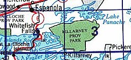
This index shows the topographic maps available for Killarney Provincial Park. Each map (e.g. 41I03) covers an area approximately 40km by 28 km.


  • Paper maps and Waterpoof maps are normally sent pre-folded. If you would prefer that we send them rolled in a tube, please specify in the Special Handling Instructions field on our Shipping Information page during checkout.
  • Topographic maps show the detail of the land and its surface features. They do not show water depths. We also sell nautical charts with the depths of major waterways.
Map Number Scale Name Paper
$12.45
Waterproof
$17.95
041I03 1:50,000 Lake Panache
041I04 1:50,000 Whitefish Falls

We also carry some useful maps and publications about enjoying Killarney Park

Northeastern Ontario Backroad Mapbook $20.95
Paddler's Guide to Killarney and the French River $19.95
Philip Edward Island & Area Sea Kayaking Guide (Map) $12.95

If you're looking to rent canoes in Killarney Provincial Park, we recommend Killarney Kanoes, outfitters located in the park.

Related Sections:
  Southern Ontario Topographic Map index

Browse By Type of Map:
  Topographic Maps
  Nautical Charts
  Aeronautical Charts
  Depth Maps and Charts
  Recreation Maps
  Park Maps
  Backroad Mapbooks

Browse By Region:
  Canada
  Alberta
  British Columbia
  Manitoba
  New Brunswick
  Newfoundland
  Northwest Territories
  Nova Scotia
  Ontario
  Prince Edward Island
  Quebec
  Saskatchewan
  Yukon
Featured Areas:
  Algonquin
  Temagami
  Banff
  Jasper
Outside Canada:
  Maps of the World
  North America

Related Reading:
  Hiking
  Paddling
  Outdoor Activities
  Nature Watching
  Travel in Ontario
Price and availability subject to change. Shipping and applicable taxes extra.

Can't find what you're looking for? Try the search button at the top of the page.
Questions about anything on this page? Please e-mail us.

Information on this page last updated: October 1, 2012

What's New · Home · Search · Books on Canada · Canadian Maps and Charts · Ordering · Contact Us
©Federal Publications Inc., 1998 - 2016
425 University Avenue, Ste. 401, Toronto, Ontario, Canada M5G 1T6
Phone: (416) 860-1611 or toll-free 1-888-433-3782 · E-mail: info@fedpubs.com