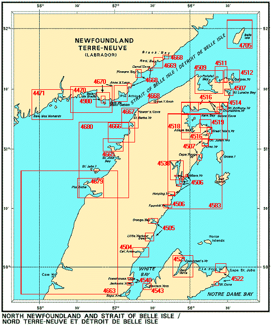
| Chart Number |
Name |
Scale |
Price |
|
| 4470 |
Blanc-Sablon to Middle Bay |
1:36 600 |
$20.00 |
 |
| 4471 |
Baie au Saumon to Baie des
Homards |
1:36 500 |
$20.00 |
|
| 4504 |
Cat Arms |
1:20 000 |
$15.00 |
|
| 4505 |
Plans on the East Coast of
Newfoundland
-Orange Bay
-Little Harbour Deep and Union Cove |
1:15 000
1:12 500
|
$20.00 |
|
| 4506 |
Plans in the vicintiy of Canada
Bay
-Fourché Harbour
-Hooping Harbour
-Hilliers
Harbor
-Otter Cove
-Grévigneux and Aiguillettes
Harbors
-Gouffre and Canaries Harbors |
1:18 300
1:11
000
1:12 500
1:16 900
1:12 600
1:12 600 |
$20.00 |
|
| 4507 |
Harbours on the
Northeast Coast of Newfoundland
-St. Lunaire Bay
-Cape Rouge
Harbor
-Croc Harbor |
1:14
800
1:15 000
1:15 000 |
$20.00 |
|
| 4509 |
Pistolet Bay
-Cape Norman Bay
and Cooks Harbour |
1:45 000
1:15
000 |
$20.00 |
|
| 4511 |
Sacred Bay |
1:15 000 |
$20.00 |
|
| 4512 |
Quirpon Harbour and Approaches
|
1:15 000 |
$20.00 |
|
| 4514 |
St. Anthony Bight and
Harbour
-St. Anthony Harbour |
1:15 000
1:7
500 |
$20.00 |
|
| 4515 |
Hare Bay |
1:45 000 |
$20.00 |
|
| 4516 |
Harbours in Hare Bay
-Goose
Cove
-Howe Harbour
-Grandois and St. Julien Harbours
-Great Islets
Harbour
-Crémaillère Harbour |
1:12 000
1:15
000
1:15 000
1:15 000
1:15 000 |
$20.00 |
|
| 4518 |
Ariege Bay |
1:25 000 |
$20.00 |
|
| 4519 |
Maiden Arm, Spring Inlets and
Approaches |
1:15 000 |
$15.00 |
|
| 4521 |
Baie Verte
-Sandy Point
Area
-Advocate Mines Wharf |
1:25 000
1:6
000
1:6 000 |
$20.00 |
|
| 4522 |
Tilt Cove and La Scie
Harbour
-Approaches to Tilt Cove
-Approaches to La Scie Harbour |
1:12 000
1:25
000 |
$20.00 |
|
| 4538 |
Canada Bay, including Chimney
Bay |
1:18 300 |
$20.00 |
|
| 4540 |
Anchorages in White
Bay
-Frenchmans Cove
-Purbeck Cove
-Jacksons Arm |
1: 120 000 |
$15.00 |
|
| 4583 |
St. Julien Island to Hooping
Harbour including Canada Bay
-Silver Cove |
1:73 500
1:9
700 |
$20.00 |
|
| 4663 |
Cow Head to Pointe Riche
-Bad
Bay |
1:144 000
1:36
500 |
$20.00 |
|
| 4665 |
St Margaret Bay and
Approaches |
1:18 300 |
$20.00 |
|
| 4666 |
St. Barbe Point to Old
Férrolle Harbour |
1:25 000 |
$20.00 |
|
| 4667 |
Savage Cove to St. Barbe
Bay
-Flowers Cove
-St. Barbe Wharf |
1:24 300
1:12
000
1:4 000 |
$20.00 |
|
| 4668 |
Anchorages in the Strait of Belle
Isle
-Anse à Loup
-Pinware Bay
-Black Bay
-Carrol
Cove
-Green Island Anchorage |
1:120 000
1:23
800
1:25 200
1:22 600
1:9 200
1:14 600 |
$15.00 |
|
| 4669 |
Red Bay |
1:12 200 |
$20.00 |
|
| 4670 |
Harbours on the Coast of Labrador
and Québec
-Forteau Bay |
1:24 400 |
$20.00 |
|
| 4679 |
Hawkes Bay, Port Saunders, Back
Arm
-Hawkes Harbour |
1:25 000
1:10
000 |
$20.00 |
|
| 4680 |
Hawkes Bay to Ste.
Geneviève Bay including St. John Bay
-St. John Harbour
-Good
Bay |
1:73 000
1:17
400
1:17 400 |
$20.00 |
|
| 4980 |
Blanc-Sablon
-Quai/Wharf
Blanc-Sablon |
1:15 000
1:5
000 |
$11.50 |
|