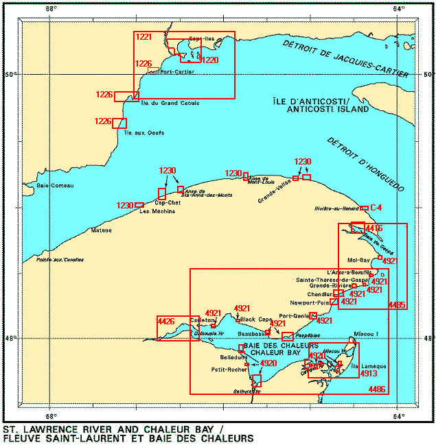
Federal Publications logo FEDERAL
PUBLICATIONS
INC.

Navigation Bar Checkout View Cart E-mail Us Canadian Maps and Charts Books on Canada Home

Nautical Charts for the St. Lawrence River and Chaleur Bay

Looking for nautical charts of the St. Lawrence River and Chaleur Bay? See below for an index to charts produced by Canadian Hydrographic Service - detailed information is available by scrolling down and clicking on an area of the map.

If you do not see what you are looking for, please feel free to ask us.
Please Note:
  • Charts are normally sent rolled in a tube for orders shipped within Canada and the United States. Charts sent to other countries are sent folded. If you would prefer to make alternate arrangements, please specify at the time of ordering. Charts sent rolled in a tube to the U.S. by mail usually take longer to arrive than folded orders.
  • Some charts are only available pre-folded, as indicated beside the chart title. These charts are only available folded, not rolled.
  • All charts are on paper, and not available in waterproof unless indicated.
Nautical Charts for the St. Lawrence River and Chaleur Bay Plan, Baie des Chaleurs / Chaleur Bay- Côte sud / South Shore Plan, Baie des Chaleurs / Chaleur Bay- Côte sud / South Shore Plan, Baie des Chaleurs / Chaleur Bay- Côte sud / South Shore Plan, Baie des Chaleurs / Chaleur Bay- Côte sud / South Shore Plan, Baie des Chaleurs / Chaleur Bay- Côte sud / South Shore Plans, Baie des Chaleurs / Chaleur Bay- Côte Nord / North Shore Plans, Baie des Chaleurs / Chaleur Bay- Côte Nord / North Shore Plans, Baie des Chaleurs / Chaleur Bay- Côte Nord / North Shore Plans, Baie des Chaleurs / Chaleur Bay- Côte Nord / North Shore Plans, Baie des Chaleurs / Chaleur Bay- Côte Nord / North Shore Plans, Baie des Chaleurs / Chaleur Bay- Côte Nord / North Shore Plans, Baie des Chaleurs / Chaleur Bay- Côte Nord / North Shore Plans, Baie des Chaleurs / Chaleur Bay- Côte Nord / North Shore Plans, Baie des Chaleurs / Chaleur Bay- Côte Nord / North Shore Plans, Baie des Chaleurs / Chaleur Bay- Côte Nord / North Shore Plans, Baie des Chaleurs / Chaleur Bay- Côte Nord / North Shore Caraquet Harbour, Baie de Shippegan et / and Miscou Harbour Baie des Chaleurs / Chaleur Bay Rivière Ristigouche / Restigouche River Havre de Gaspé Cap des Rosiers à / to Chandler Rivière-au-Renard Plans, Péninsule de la Gaspésie Plans, Péninsule de la Gaspésie Plans, Péninsule de la Gaspésie Plans, Péninsule de la Gaspésie Plans, Péninsule de la Gaspésie Plans, Péninsule de la Gaspésie Mouillages/Anchorages, Haute Côte-Nord Mouillages/Anchorages, Haute Côte-Nord Mouillages/Anchorages, Haute Côte-Nord Baie des Sept-îles Pointe de Moisie à/to île du Grand Caouis
Chart Number Name Scale Price  
C-4 Rivière-au-Renard 1:10 000 $5.50 Not Available - Withdrawn
1220 Baie des Sept-îles
-Pointe Noire
-Sept-Îles
1:25 000
1:10 000
1:10 000
$20.00 Add to Cart
1221 Pointe de Moisie to île du Grand Caouis 1:75 000 $20.00 Add to Cart
1226 Mouillages et Installations Portuaires/ Anchorages and Harbour Installations, Haute Côte-Nord
-Baie-Comeau
-Îles aux Oeufs
-Baie des Homards
-Port-Cartier

1:20 000
1:50 000
1:50 000
1:15 000
$20.00 Add to Cart
1230 Plans, Péninsule de la Gaspésie
-Mont-Louis
-Sainte-Anne-des-Mohts
-CapChat
-Les Mechins
-Rivière-au-Renard
-Grand-Vallée

1:24 000

1:12 000
1:12 000
1:10 000
1:7 200
$20.00 Add to Cart
4416 Havre de Gaspé
-Marina de Gaspé
-Quai Public/Public Wharf
1:12 000
1:4 000
1:4 000
$20.00 Add to Cart
4426 Restigouche River
-Dalhousie Harbour
1:36 400
1:7 200
$20.00 Add to Cart
4485 Cap des Rosiers to Chandler 1: 75 000 $20.00 Add to Cart
4486 Chaleur Bay 1:150 000 $20.00 Add to Cart
4913 Caraquet Harbour, Baie de Shippegan and Miscou Harbour 1:40 000 $20.00 Add to Cart
4920 Plan, Chaleur Bay / South Shore
-Bathurst Harbour
-Quai/Wharf Petit-Rocher
-Quai/Whart Belledune
-Lamèque
-Caraquet
-Middle Caraquet
-Bas-Caraquet
-Shippegan Harbour

1:15 000
1:5 000
1:10 000
1:5 000
1:5 000
1:5 000
1:5 000
1:20 000
$20.00 Add to Cart
4921 Plans, Chaleur Bay / North Shore
-Mal-Bay
-L'Anse-à-Beaufils
-Sainte-Thérèse-de-Gaspé
-Grande-Rivière
-Chandler
-Newport-Point
-Baie de Port Daniel
-Approaches to Paspébiac
-Havre de Beaubassin
-Black-Cape
-Carleton

1:5 000
1:5 000
1:5 000
1:10 000
1:20 000
1:10 000
1:20 000
1:50 000
1:5 000
1:5 000
1:5 000
$20.00 Add to Cart
Price and availability subject to change. Shipping and applicable taxes extra.
Questions about anything on this page? Please e-mail us.
This page last modified: January 18, 2006

Index: Atlantic Coast
What's New · Home · Search · Books on Canada · Canadian Maps and Charts · Ordering · E-mail Us

©Federal Publications Inc., 1998 - 2008
165 University Avenue, Toronto, Ontario, Canada M5H 3B8
Phone: (416) 860-1611 or toll-free 1-888-433-3782 · E-mail: info@fedpubs.com