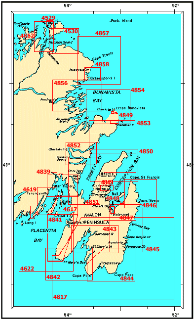
| Chart Number |
Name |
Scale |
Price |
|
| 4529 |
Fogo Harbour, Seal
Cove and Approches
-Fogo Harbour and Seal Cove
-Western Entrance to Fogo
Harbour
-Eastern Entrance to Fogo Harbour |
1:20 000
1:7
500
1:4 000
1:4 000 |
$20.00 |
 |
| 4530 |
Hamilton Sound,
Eastern Portion
-Carmanville |
1:40 000
1:18
000 |
$20.00 |
|
| 4617 |
Red Island to
Pinchgut Point
-Buffett Harbour
-Long Harbour, Erco Wharf |
1:37 500
1:6
000
1:6 000 |
$20.00 |
|
| 4619 |
Presque Harbour to
Bar Haven Island and Paradise Sound |
1:37 500 |
$20.00 |
|
| 4622 |
Cape St Mary's to
Argentia Harbour and Jude Island |
1:80 000 |
$20.00 |
|
| 4817 |
Bay Bulls to St
Mary's Bay |
1:150 000 |
$20.00 |
|
| 4839 |
Head of Placentia
Bay
-Come by Chance and Arnold's Cove |
1:40 000
1:20
000 |
$20.00 |
|
| 4841 |
Cape St Mary's to
Argentia
-Argentia
-Placentia Road
-St Bride's |
1:60 000
1:20
000
1:20 000
1:5 000 |
$20.00 |
|
| 4842 |
Cape Pine to Cape St
Mary's |
1:60 000 |
$20.00 |
|
| 4843 |
Head of St Mary's
Bay
-St Mary's Harbour and Adjacent Anchorages |
1:60 000
1:30
000 |
$20.00 |
|
| 4844 |
Cape Pine to Renews
Harbour
-Renews Harbour
-Trepassey Harbour |
1:60 000
1:25
000
1:20 000 |
$20.00 |
|
| 4845 |
Renews Harbour to
Motion Bay
-Bay Bulls and Witless Bay
-Aquaforte Harbour
-Fermeuse
Harbour
-Lumley Cove |
1:60 000
1:25
000
1:30 000
1:25 000
1:4 500 |
$20.00 |
|
| 4846 |
Motion Bay to Cape
St. Francis
-Quidi Vidi Harbour
-St John's Harbour |
1:60 000
1:5
000
1:5 000 |
$20.00 |
|
| 4847 |
Conception
Bay
-Port De Grave
-Bell Island
-Foxtrap
-Portugal Cove |
1:60 000
1:5
000
1:2 500
1:5 000
1:3 000 |
$20.00 |
|
| 4848 |
Holyrood and Long
Pond
-Long Pond
-Holyrood
-Holyrood (Marina)
-Ultramar
(Wharf/Quai)
-Generator Plant (Wharf) |
1:2 500
1:15
000
1:3 000
1:3 000
1:3 000 |
$20.00 |
|
| 4849 |
Plans, Conception
Bay, Trinity Bay and Bonavista Harbour
-Bonavista Harbour
-Catalina and
Port Union
-Catalina Harbour
-Port Union
-Harbour Grace and
Carbonear
-Fish Plant
-Irving Oil Wharf
-Public Wharf |
1:5 000
1:15
000
1:5 000
1:5 000
1:25 000
1:3 000
1:1 000
1:3 000 |
$20.00 |
|
| 4850 |
Cape St. Francis to
Baccalieu Island and Heart's Content-Heart's Content
-Old Perlican
|
1:60 000
1:20
000
1:15 000 |
$20.00 |
|
| 4851 |
Trinity Bay -
Southern Portion |
1:60 000 |
$20.00 |
|
| 4852 |
Smith Sound and
Random Sound
-Clarenville |
1:40 000
1:5
000 |
$20.00 |
|
| 4853 |
Trinity Bay -
Northern Portion
-Trinity Harbour
-Trinity Wharves |
1:60 000
1:25
000
1:2 500 |
$20.00 |
|
| 4854 |
Catalina Harbour to
Inner Gooseberry Island |
1:60 000 |
$20.00 |
|
| 4855 |
Bonavista Bay -
Southern Portion |
1:60 000 |
$20.00 |
|
| 4856 |
Bonavista Bay -
Western Portion |
1:60 000 |
$20.00 |
|
| 4857 |
Indian Bay to Wadham
Islands
-Lumsden Harbour |
1:60 000
1:20
000 |
$20.00 |
|
| 4858 |
Greenspond Harbour to
Pound Cove
-Valleyfield
-Wesleyville |
1:20 000
1:5
000
1:5 000 |
$20.00 |
|
| 4862 |
Carmanville to
Bacalhao Island and Fogo |
1:40 000 |
$20.00 |
|