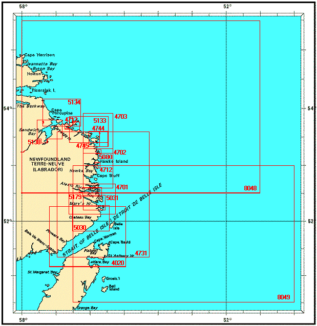
Federal Publications logo FEDERAL
PUBLICATIONS
INC.

Navigation Bar Checkout View Cart Contact Us Canadian Maps and Charts Books on Canada Home

Nautical Charts for the Strait of Belle Isle and the East Coast of Labrador

Looking for nautical charts of the east coast of Labrador? See below for an index to charts produced by Canadian Hydrographic Service - detailed information is available by scrolling down and clicking on an area of the map.

If you do not see what you are looking for, please feel free to ask us.
Please Note:
  • Charts are normally sent rolled in a tube for orders shipped within Canada and the United States. Charts sent to other countries are sent folded. If you would prefer to make alternate arrangements, please specify at the time of ordering. Charts sent rolled in a tube to the U.S. by mail usually take longer to arrive than folded orders.
  • Some charts are only available pre-folded, as indicated beside the chart title. These charts are only available folded, not rolled.
  • All charts are on paper, and not available in waterproof unless indicated.

 
Charts of Belle Isle and the East Coast of Labrador Approaches to White Bear Arm Hawke Bay and Squasho Run Plans on the Coast of Labrador Approach to Spotted Island Harbor White Point to Sandy Island Domino Point to Cape North Sandwich Bay Approaches to Cartwright, Black Island to Tumbledown Dick Island Plans on the Coast of Labrador Punchbowl and Approaches/et les Approches White Point to Corbet Island Corbet Island to Ship Harbour Head St. Lewis Sound and/et Inet Alexis Bay and River Ship Harbour Head to Camp Islands Green Bay to/à Double Island Strait of Belle Isle to Domino Run Strait of Belle Isle St. Michael Bay to Gray Islands St. Michael Bay to Gray Islands Cape Harrison to St. Michael Bay
Chart Number Name Scale Price  
4020 Strait of Belle Isle 1:150 000 $20.00 Add to Cart
4701 Ship Harbour Head to Camp Islands
-St. Francis Harbor
-Fishing Ship Harbor
-Occasional Harbor
-Port Charlotte, Mecklenberg and Sophia Harbors
1:75 000
1:25 000
1:25 000
1:25 000
1:25 000
$20.00 Add to Cart
4702 Corbet Island to Ship Harbour Head
-American Tickle
-Boulter Rock
-St. Michaels Bay
1:75 000
1:20 000
1:20 000
1:15 000
$20.00 Add to Cart
4703 White Point to Corbet Island 1:75 000 $20.00 Add to Cart
4712 Plans on the Coast of Labrador
-Table Bay
-Approaches to Hawke Harbor

1:30 000
1:30 000
$20.00 Add to Cart
4731 Strait of Belle Isle to Domino Run 1:250 000 $20.00 Add to Cart
4744 Approach to Spotted Island Harbor
-Spotted Island Harbour
1:30 000
1:4 000
$20.00 Add to Cart
4745 White Point to Sandy Island 1:30 000 $20.00 Add to Cart
5030 Green Bay to Double Island
-Chateau Bay
-Niger Sound
1:60 000
1:20 000
1:30 000
$20.00 Add to Cart
5031 St. Lewis Sound and Inet 1:40 000 $20.00 Add to Cart
5032 Approaches to White Bear Arm 1:30 000 $20.00 Add to Cart
5033 Hawke Bay and Squasho Run 1:30 000 $20.00 Add to Cart
5080 Punchbowl and Approaches 1:25 000 $11.50 Add to Cart
5133 Domino Point to Cape North 1:75 000 $20.00 Add to Cart
5134 Approaches to Cartwright, Black Island to Tumbledown Dick Island 1:75 000 $20.00 Add to Cart
5138 Sandwich Bay
-Cartwright Harbour
-Paradise River
1:50 000
1:15 000
1:15 000
$20.00 Add to Cart
5179 Alexis Bay and River
-Alexis Bay
-Alexis River
-Williams Harbour

1:40 000
1:20 000
1:20 000
$20.00 Add to Cart
8048 Cape Harrison to St. Michael Bay 1:500 000 $20.00 Add to Cart
8049 St. Michael Bay to Gray Islands 1:500 000 $20.00 Add to Cart

Related Sections:
  Atlantic Chart Index
  General Atlantic Charts
  Coastal Atlantic Charts
  Anticosti Island Charts
  Avalon Peninsula Charts
  Bay of Fundy Charts
  Cape Breton Island Charts
  Central Nfld Charts
  Central Nova Scotia Charts
  Chaleur Bay Charts
  Northern Nfld Charts
  Hudson Strait Charts
  Labrador Sea Charts
  Prince Edward Island Charts
  Southern Nova Scotia Charts
  Southern Nfld Charts
  St. Lawrence Charts

Browse By Type of Map:
  Topographic Maps
  Nautical Charts
  Aeronautical Charts
  Depth Maps and Charts
  Recreation Maps
  Park Maps
  Backroad Mapbooks
  Digital Topographic Maps

Browse By Region:
  Canada
  Alberta
  British Columbia
  Manitoba
  New Brunswick
  Newfoundland
  Northwest Territories
  Nova Scotia
  Nunavut
  Ontario
  Prince Edward Island
  Quebec
  Saskatchewan
  Yukon
Featured Areas:
  Algonquin
  Killarney
  Temagami
  Banff
  Jasper
Outside Canada:
  Maps of the World
  North America

Related Reading:
  Boating in Canada
  Sailing Directions
  List of Lights
  Radio Aids
  Tide and Current Tables
Price and availability subject to change. Shipping and applicable taxes extra.

Can't find what you're looking for? Try the search button at the top of the page.
Questions about anything on this page? Please e-mail us.

Information on this page last updated: April 19, 2011

What's New · Home · Search · Books on Canada · Canadian Maps and Charts · Ordering · Contact Us
©Federal Publications Inc., 1998 - 2016
425 University Avenue, Ste. 401, Toronto, Ontario, Canada M5G 1T6
Phone: (416) 860-1611 or toll-free 1-888-433-3782 · E-mail: info@fedpubs.com