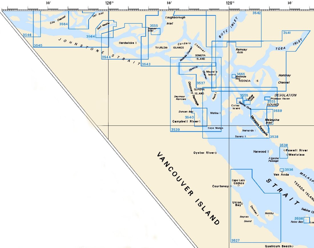
Federal Publications logo FEDERAL
PUBLICATIONS
INC.

Navigation Bar Checkout View Cart Contact Us Canadian Maps and Charts Books on Canada Home

Larger Scale Nautical Charts for North Vancouver Island, British Columbia

Looking for nautical charts of North Vancouver Island? See below for an index to charts produced by Canadian Hydrographic Service - detailed information is available by scrolling down and clicking on an area of the map.

If you do not see what you are looking for, please feel free to ask us.
Please Note:
  • Charts are normally sent rolled in a tube for orders shipped within Canada and the United States. Charts sent to other countries are sent folded. If you would prefer to make alternate arrangements, please specify at the time of ordering. Charts sent rolled in a tube to the U.S. by mail usually take longer to arrive than folded orders.
  • Some charts are only available pre-folded, as indicated beside the chart title. These charts are only available folded, not rolled.
  • All charts are on paper, and not available in waterproof unless indicated.

 
Chart Index for North Vancouve Island 3564 Plans - Johnstone Strait 3564 Plans - Johnstone Strait 3559 Malaspina Inlet, Okeover Inlet and/et Lancelot Inlet 3555 Plans - Vicinity of/Proximité de Redonda Islands and/et Loughborough Inlet 3555 Plans - Vicinity of/Proximité de Redonda Islands and/et Loughborough Inlet 3555 Plans - Vicinity of/Proximité de Redonda Islands and/et Loughborough Inlet 3555 Plans - Vicinity of/Proximité de Redonda Islands and/et Loughborough Inlet 3555 Plans - Vicinity of/Proximité de Redonda Islands and/et Loughborough Inlet 3544 Johnstone Strait, Race Passage and/et Current Passage 3540 Approaches to/Approches à Campbell River 3537 Okisollo Channel 3536 Plans - Strait of Georgia 3536 Plans - Strait of Georgia 3536 Plans - Strait of Georgia 3546 Broughton Strait 3545 Johnstone Strait, Port Neville to/à Robson Bight 3543 Cordero Channel 3542 Bute Inlet 3541 Approaches to/Approches à Toba Inlet 3539 Discover Passage 3538 Desolation Sound and/et Sutil Channel 3527 Baynes Sound

Chart Number Name Scale Price  
3527 Baynes Sound
-Comox Harbour
1:40,000
1:15,000
$20.00 Add to Cart
3536 Plans - Strait of Georgia
-False Bay
-Powell River and Westview
-Sturt Bay and Vananda Cove

1:12,000
1:10,000
1:8,000
$20.00 Add to Cart
3537 Okisollo Channel
-Whiterock Passage
1:20,000
1:10,000
$20.00 Add to Cart
3538 Desolation Sound and Sutil Channel 1:40,000 $20.00 Add to Cart
3539 Discovery Passage
-Seymour Narrows
1:40,000
1:20,000
$20.00 Add to Cart
3540 Approaches to Campbell River 1:10,000 $20.00 Add to Cart
3541 Approaches to Toba Inlet 1:40,000 $20.00 Add to Cart
3542 Bute Inlet 1:40,000 $20.00 Add to Cart
3543 Cordero Channel
-Green Point Rapids
-Dent and Yuculta Rapids
1:40,000
1:20,000
1:20,000
$20.00 Add to Cart
3544 Johnstone Strait, Race Passage and Current Passage 1:25,000 $20.00 Add to Cart
3545 Johnstone Strait, Port Neville to Robson Bight 1:40,000 $20.00 Add to Cart
3546 Broughton Strait
-Port McNeill
-Alert Bay
1:40,000
1:20,000
1:20,000
$20.00 Add to Cart
3555 Plans - Vicinity of Redonda Islands and Loughborough Inlet
-Refuge Cove
-Squirrel Cove
-Redonda Bay
-Beaver Inlet
-Prideaux Haven
1:12,000
1:12,000
1:12,000
1:18,000
1:6,000
$20.00 Add to Cart
3559 Malaspina Inlet, Okeover Inlet and Lancelot Inlet 1:12,000 $20.00 Add to Cart
3564 Plans - Johnstone Strait
-Port Neville
-Havannah Channel and Chatham Channel
-Chatham Channel

1:20,000
1:20,000
1:10,000
$20.00 Add to Cart

Related Sections:
  Pacific Chart Index
  Pacific General Charts
  Pacific Small Craft Charts
  North Coast of B.C.
  South Coast of B.C.
  Large Scale North B.C.
  Large Scale North Vancouver Island
  Large Scale South Vancouver Island
  Queen Charlotte Islands
  Digital Nautical Charts

Browse By Type of Map:
  Topographic Maps
  Nautical Charts
  Aeronautical Charts
  Depth Maps and Charts
  Recreation Maps
  Park Maps
  Backroad Mapbooks
  Digital Topographic Maps

Browse By Region:
  Canada
  Alberta
  British Columbia
  Manitoba
  New Brunswick
  Newfoundland
  Northwest Territories
  Nova Scotia
  Nunavut
  Ontario
  Prince Edward Island
  Quebec
  Saskatchewan
  Yukon
Featured Areas:
  Algonquin
  Killarney
  Temagami
  Banff
  Jasper
Outside Canada:
  Maps of the World
  North America

Related Reading:
  Boating in Canada
  Sailing Directions
  West Coast Cruising Guides and Chart Books
  List of Lights
  Radio Aids
  Tide and Current Tables
Price and availability subject to change. Shipping and applicable taxes extra.

Can't find what you're looking for? Try the search button at the top of the page.
Questions about anything on this page? Please e-mail us.

Information on this page last updated: April 19, 2011

What's New · Home · Search · Books on Canada · Canadian Maps and Charts · Ordering · Contact Us
©Federal Publications Inc., 1998 - 2016
425 University Avenue, Ste. 401, Toronto, Ontario, Canada M5G 1T6
Phone: (416) 860-1611 or toll-free 1-888-433-3782 · E-mail: info@fedpubs.com