| |
|
| Chart
Number |
Name |
Scale |
Price |
|
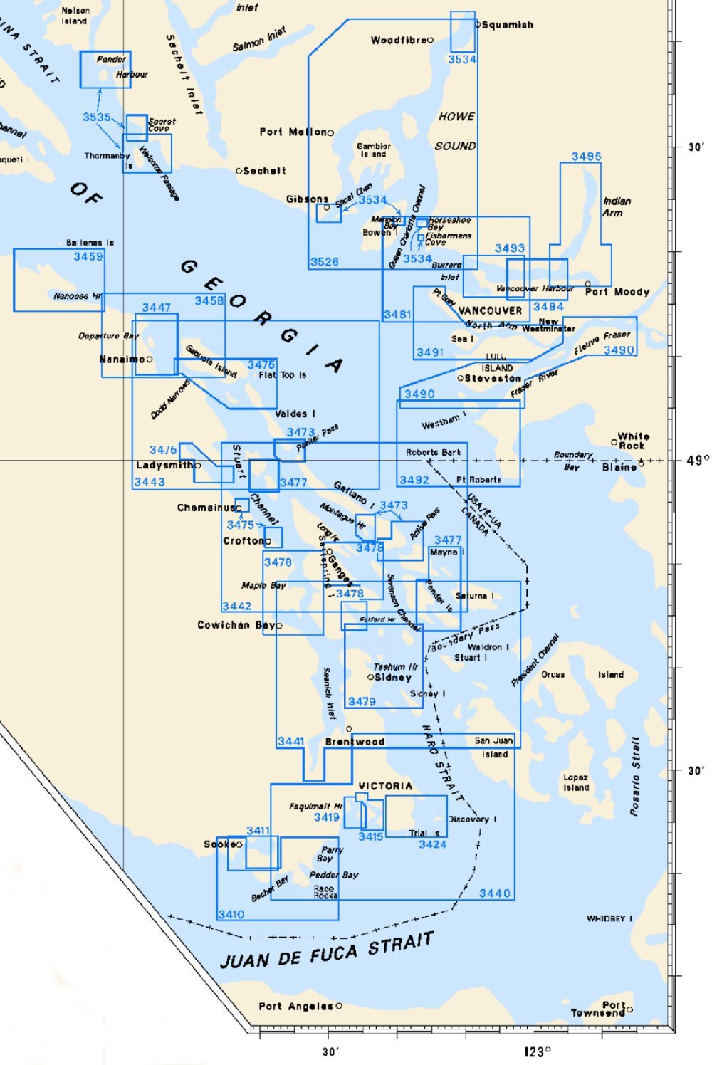
| 3410 |
Sooke Inlet to
Parry Bay
-Pedder Bay |
1:20,000
1:6,000 |
$20.00 |
 |
| 3411 |
Sooke |
1:12,000 |
$15.00 |
|
| 3412 |
Victoria
Harbour |
1:5,000 |
$20.00 |
|
| 3419 |
Esquimalt
Harbour |
1:5,000 |
$20.00 |
|
| 3424 |
Approaches to Oak
Bay |
1:10,000 |
$20.00 |
|
| 3440 |
Race Rocks to
D'Arcy Island |
1:40,000 |
$20.00 |
|
| 3441 |
Haro Strait,
Boundary Pass and Satellite Channel |
1:40,000 |
$20.00 |
|
| 3442 |
North Pender Island
to Thetis Island |
1:40,000 |
$20.00 |
|
| 3443 |
Thetis Island to
Nanaimo |
1:40,000 |
$20.00 |
|
| 3447 |
Nanaimo Harbour and
Departure Bay |
1:10,000 |
$20.00 |
|
| 3458 |
Approaches to
Nanaimo Harbour |
1:20,000 |
$20.00 |
|
| 3459 |
Approaches to
Nanoose Harbour |
1:15,000 |
$20.00 |
|
| 3473 |
Active Pass,
Porlier Pass and Montague Harbour
-Active Pass
-Porlier Pass
-Montague
Harbour |
1:12,000
1:12,000
1:18,000 |
$20.00 |
|
| 3475 |
Plans - Stuart
Channel
-Chemainus Bay
-Ladysmith Harbour
-Dodd Narrows to Flat Top
Islands
-Dodd Narrows
-Osborn Bay |
1:12,000
1:12,000
1:18,000
1:9,000
1:15,000 |
$20.00 |
|
| 3477 |
Plans - Gulf
Islands
-Bedwell Harbour to Georgeson Passage
-Telegraph Harbour and
Preedy Harbour
-Pender Canal |
1:15,000
1:15,000
1:4,000 |
$20.00 |
|
| 3478 |
Plans - Saltspring
Island -Sansum Narrows
-Birds Eye Cove
-Genoa Bay
-Ganges Harbour and
Long Harbour
-Fulford Harbour |
1:20,000
1:10,000
1:10,000
1:20,000
1:15,000 |
$20.00 |
|
| 3479 |
Approaches to
Sidney |
1:20,000 |
$20.00 |
|
| 3481 |
Approaches to
Vancouver Harbour |
1:25.000 |
$20.00 |
|
| 3490 |
Fraser River, Sand
Heads to Douglas Island |
1:20,000 |
$20.00 |
|
| 3491 |
Fraser River, North
Arm |
1:20,000 |
$20.00 |
|
| 3492 |
Roberts Bank |
1:20,000 |
$20.00 |
|
| 3493 |
Vancouver Harbour,
Western Portion |
1:10,000 |
$20.00 |
|
| 3494 |
Vancouver Harbour,
Central Portion
-Second Narrows |
1:10,000
1:6,000 |
$20.00 |
|
| 3495 |
Vancouver Harbour,
Eastern Portion
-Indian Arm |
1:10,000
1:30,000 |
$20.00 |
|
| 3526 |
Howe Sound |
1:40,000 |
$20.00 |
|
| 3534 |
Plans - Howe
Sound
-Mannion Bay and Snug Cove
-Fishermans Cove
-Horseshoe
Bay
-Shoal Channel
-Squamish Harbour |
1:8,000
1:3,000
1:8,000
1:12,000
1:10,000 |
$20.00 |
|
| 3535 |
Plans - Malaspina
Strait
-Pender Harbour
-Secret Cove and Smuggler Cove
-Welcome
Passage |
1:12,000
1:10,000
1:25,000 |
$20.00 |
|
|
|