| |
|
| Chart
Number |
Name |
Scale |
Price |
|
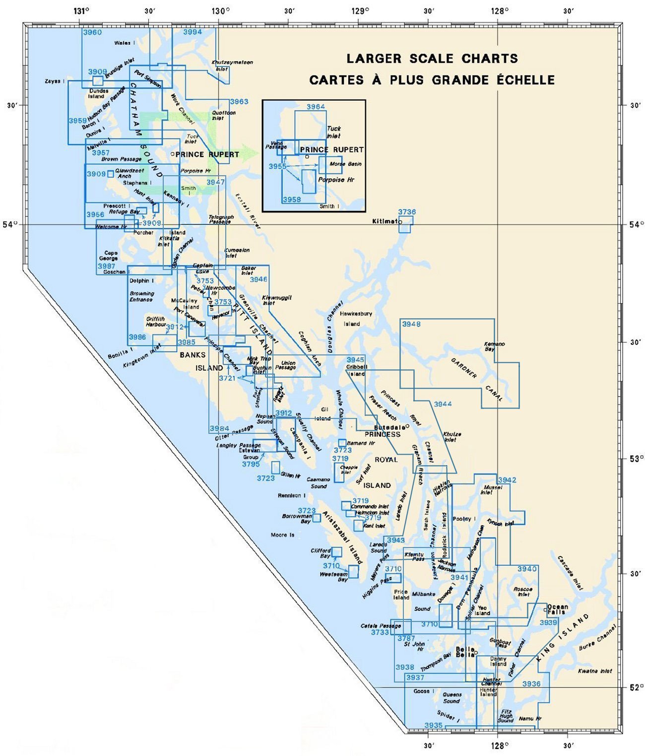
| 3721 |
Harbours on the
West Coast of Pitt Island
-Mink Trap Bay and Adjacent Inlets
-Port
Stephens and Monckton Inlet
-Buchan Inlet |
1:18,300
|
$20.00 |
|
| 3733 |
Catala Passage
|
1:20,000 |
$15.00 |
|
| 3736 |
Kitmat and Kemano
Bay |
1:12,200 |
$20.00 |
|
| 3795 |
Langley Passage,
Estevan Group |
1:12,000 |
$20.00 |
|
| 3909 |
Plans - Chatham
Sound
-Welcome Harbour
-Refuge Bay
-Hunt Inlet
-Qlawdzeet
Anchorage
-Brundige Inlet |
1:15,000
1:10,000
1:10,000
1:10,000
1:10,000 |
$20.00 |
|
| 3910 |
Plans - Milbanke
Sound and Beauchemin Channel |
1:20,000 |
$20.00 |
|
| 3911 |
Plans - Vicinity
of Princess Royal Island |
1:25,000 |
$20.00 |
|
| 3912 |
Plans, Vicinity of
Banks Island |
1:25,000 |
$20.00 |
|
| 3936 |
Fitz Hugh Sound to
Lama Passage
-Namu Harbour |
1:40,000
1:20,000 |
$20.00 |
|
| 3937 |
Queens Sound |
1:40,000 |
$20.00 |
|
| 3938 |
Queens Sound to
Seaforth Channel |
1:40,000 |
$20.00 |
|
| 3939 |
Fisher Channel to
Seaforth Channel and:
-Dean Channel
-Ocean Falls
-Gunboat
Passage
-Shearwater
-Troup Narrows |
1:40,000
1:15,000
1:12,000
1:12,000
1:6,000 |
$20.00 |
|
| 3940 |
Spiller Channel and
Roscoe Inlet |
1:40,000 |
$20.00 |
|
| 3941 |
Channels Vicinity
of Milbanke Sound |
1:40,000 |
$20.00 |
|
| 3942 |
Mathieson Channel
Northern Portion |
1:40,000 |
$20.00 |
|
| 3943 |
Finlayson Channel
and Tolmie Channel |
1:40,000 |
$20.00 |
|
| 3944 |
Princess Royal
Channel |
1:40,000 |
$20.00 |
|
| 3945 |
Approaches to
Douglas Channel |
1:40,000 |
$20.00 |
|
| 3946 |
Grenville
Channel |
1:40,000 |
$20.00 |
|
| 3947 |
Grenville Channel
to Chatham Sound |
1:40,000 |
$20.00 |
|
| 3948 |
Gardner
Canal |
1:40 000 |
$20.00 |
|
| 3955 |
Plans - Prince
Rupert Harbour
-Porpoise Island, Ridley Island and Approaches
-Venn
Passage
-Morse Basin and Denise Inlet |
1:10,000
1:12,000
1:20,000 |
$20.00 |
|
| 3956 |
Malacca Passage to
Bell Passage |
1:40,000 |
$20.00 |
|
| 3957 |
Approaches to
Prince Rupert Harbour |
1:40,000 |
$20.00 |
|
| 3958 |
Prince Rupert
Harbour
-Butze Rapids |
1:20,000
1:5,000 |
$20.00 |
|
| 3959 |
Hudson Bay Passage
|
1:40,000 |
$20.00 |
|
| 3960 |
Approaches to
Portland Inlet |
1:40,000 |
$20.00 |
|
| 3963 |
Work
Channel
-Lax Kw'alaams
-Quottoon Narrows |
1:40,000
1:2,500
1:20,000 |
$20.00 |
|
| 3964 |
Tuck
Inlet
-Tuck Narrows |
1:20,000
1:10,000 |
$15.00 |
|
| 3984 |
Principe Channel
Southern Portion |
1:40,000 |
$20.00 |
|
| 3985 |
Principe Channel
Central Portion |
1:40,000 |
$20.00 |
|
| 3986 |
Browning
Entrance |
1:40,000 |
$20.00 |
|
| 3987 |
Kitkatla Channel
and Porcher Island |
1:40,000 |
$20.00 |
|
| 3994 |
Portland Inlet,
Khutzeymateen Inlet and Pearse Canal |
1:40,000 |
$20.00 |
|
|
|