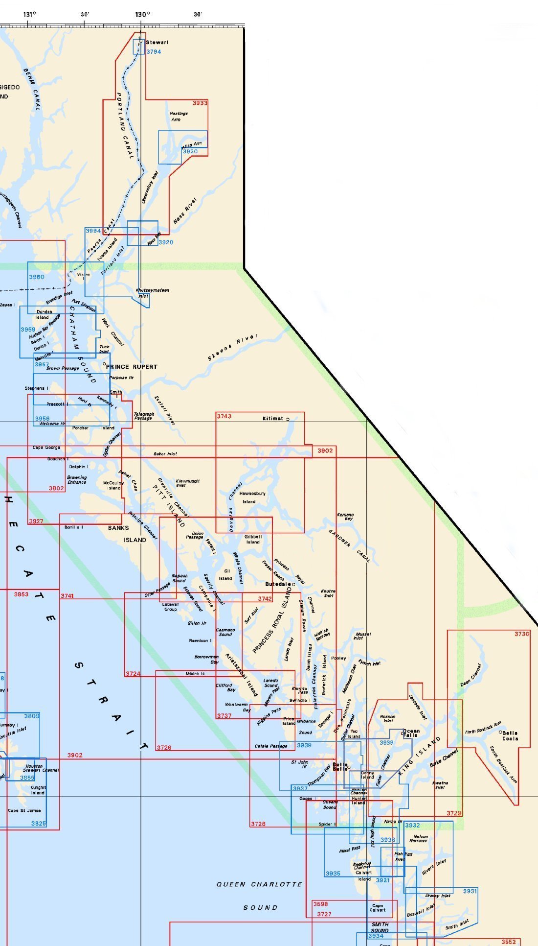
Federal Publications logo FEDERAL
PUBLICATIONS
INC.

Navigation Bar Contact Us Canadian Maps and Charts Books on Canada Home

Nautical Charts for Northern British Columbia

For information on charts for Southern British Columbia produced by Canadian Hydrographic Service, click an area of the index below, or see our price list to order.

Digital Charts on CD-ROM are also available for this region.

If you do not see what you are looking for, please feel free to ask us.
Please Note:
  • Charts are normally sent rolled in a tube for orders shipped within Canada and the United States. Charts sent to other countries are sent folded. If you would prefer to make alternate arrangements, please specify at the time of ordering. Charts sent rolled in a tube to the U.S. by mail usually take longer to arrive than folded orders.
  • Some charts are only available pre-folded, as indicated beside the chart title.
  • All charts are printed on paper and are not available in waterproof unless indicated.

  Chart Index for Northern British Columbia Queen's Sound to Seaforth Channel 3598 Cape Scott to Cape 3934 Approaches to/Approches à Smith Sound and/et Rivers Inlet 3727 Cape Calvert to Goose Island including Fitz Hugh Sound Charts of the Queen Charlotte Islands 3921 Fish Egg Inlet and/et Allison Harbour 3920 Nass Bay, Alice Arm and Approaches/et les approches 3920 Nass Bay, Alice Arm and Approaches/et les approches 3794 Stewart 3994 Portland Inlet, Khutzeymateen Inlet and Pearse Canal 3960 Approaches to/Approches à Portland Inlet 3959 Hudson Bay Passage 3957 Approaches to/Approches à Prince Rupert Harbour 3956 Malacca Passage to/à Bell Passage 3937 Queens Sound 3936 Fitz Hugh Sound to/à Lama Passage 3935 Hakai Passage and Vicinity/et Environs 3934 Approaches to/Approches à Smith Sound and/et Rivers Inlet 3932  Rivers Inlet 3931  Smith Inlet, Boswell Inlet and/et Draney Inlet 3939 Fisher Channel to/à Seaforth Channel and/et Dean Channel 3743 Douglas Channel 3742 Otter Passage to/à McKay Reach 3741 Otter Passage to Bonilla Island 3737 Laredo Channel (including/y compris Laredo Inlet and/et Surf Inlet Dean Channel, Burke Channel and/et Bentinck Arms 3728 Milbanke Sound and Approaches/et les approches 3727 Cape Calvert to Goose Island including Fitz Hugh Sound 3726 Laredo Sound and Approaches 3724 Caamano Sound and Approaches/et les approches 3933 Portland Canal and/et Observatory Inlet 3800 Dixon Entrance 3902 Hecate Strait
Chart Number Name Scale Price  
3598 Cape Scott to Cape Calvert 1:74,500 $20.00
3724 Caamano Sound and Approaches 1:71,600 $20.00
3726 Laredo Sound and Approaches 1:72,200 $20.00
3727 Cape Calvert to Goose Island including Fitz Hugh Sound 1:73,600 $20.00
3728 Milbanke Sound and Approaches 1:76,600 $20.00
3737 Laredo Channel (including Laredo Inlet and Surf Inlet) 1:77,400 $20.00
3741 Otter Passage to Bonilla Island 1:72,900 $20.00
3742 Otter Passage to McKay Reach 1:70,900 $20.00
3743 Douglas Channel 1:73,000 $20.00
3794 Stewart 1:12,000 $15.00
3800 Dixon Entrance 1:200,000 $20.00
3902 Hecate Strait 1:250,000 $20.00
3920 Nass Bay, Alice Arm and Approaches
-Alice Arm
-Nass Bay
1:25,000
1:40,000
$20.00
3921 Fish Egg Inlet and Allison Harbour
-Allison Harbour
-Fish Egg Inlet
1:20,000 $20.00
3927 Bonilla Island to Edye Passage 1:77,800 $20.00
3931 Smith Inlet, Boswell Inlet and Draney Inlet
-Draney Narrows
1:40,000
1:20,000
$20.00
3932 Rivers Inlet
-Nelson Narrows
1:40,000
1:10,000
$20.00
3933 Portland Canal and/et Observatory Inlet 1:80,000 $20.00
3934 Approaches to Smith Sound and Rivers Inlet
-Darby Channel
1:40,000
1:15,000
$20.00
3935 Hakai Passage and Vicinity/et Environs 1:40,000 $20.00
3936 Fitz Hugh Sound to Lama Passage
-Namu Harbour
1:40,000
1:20,000
$20.00
3937 Queens Sound 1:40,000 $20.00
3938 Queen's Sound to Seaforth Channel 1:40 000 $20.00
3939 Fisher Channel to Seaforth Channel and:
-Dean Channel
-Ocean Falls
-Gunboat Passage
-Shearwater
-Troup Narrows

1:40,000
1:15,000
1:12,000
1:12,000
1:6,000
$20.00
3956 Malacca Passage to Bell Passage 1:40,000 $20.00
3957 Approaches to Prince Rupert Harbour 1:40,000 $20.00
3959 Hudson Bay Passage 1:40,000 $20.00
3960 Approaches to Portland Inlet 1:40,000 $20.00
3974 Dean Channel, Burke Channel and Bentinck Arms 1:80,000 $20.00
3994 Portland Inlet, Khutzeymateen Inlet and Pearse Canal 1:40,000 $20.00

Related Sections:
  Pacific Chart Index
  Pacific General Charts
  Pacific Small Craft Charts
  North Coast of B.C.
  South Coast of B.C.
  Large Scale North B.C.
  Large Scale North Vancouver Island
  Large Scale South Vancouver Island
  Queen Charlotte Islands
  Charts on CD-ROM

Browse By Type of Map:
  Topographic Maps
  Nautical Charts
  Aeronautical Charts
  Depth Maps and Charts
  Recreation Maps
  Park Maps
  Backroad Mapbooks
  Digital Topographic Maps

Browse By Region:
  Canada
  Alberta
  British Columbia
  Manitoba
  New Brunswick
  Newfoundland
  Northwest Territories
  Nova Scotia
  Nunavut
  Ontario
  Prince Edward Island
  Quebec
  Saskatchewan
  Yukon
Featured Areas:
  Algonquin
  Killarney
  Temagami
  Banff
  Jasper
Outside Canada:
  Maps of the World
  North America

Related Reading:
  Boating in Canada
  Sailing Directions
  West Coast Cruising Guides and Chart Books
  List of Lights
  Radio Aids
  Tide and Current Tables
Price and availability subject to change. Shipping and applicable taxes extra.

Can't find what you're looking for? Try the search button at the top of the page.
Questions about anything on this page? Please e-mail us.

Information on this page last updated: April 26, 2012

What's New · Home · Search · Books on Canada · Canadian Maps and Charts · Ordering · Contact Us
©Federal Publications Inc., 1998 - 2016
425 University Avenue, Ste. 401, Toronto, Ontario, Canada M5G 1T6
Phone: (416) 860-1611 or toll-free 1-888-433-3782 · E-mail: info@fedpubs.com