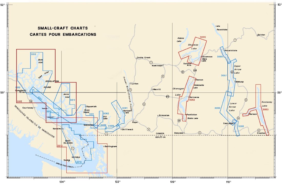
Federal Publications logo FEDERAL
PUBLICATIONS
INC.

Navigation Bar Contact Us Canadian Maps and Charts Books on Canada Home

Small-Craft Charts of Pacific Canada

For information on small-craft charts of the Pacific Coast of Canada produced by Canadian Hydrographic Service, click an area of the index below, or see our price list to order.

Digital Charts on CD-ROM are also available for this region.

If you do not see what you are looking for, please feel free to ask us.
Please Note:
  • Charts are normally sent rolled in a tube for orders shipped within Canada and the United States. Charts sent to other countries are sent folded. If you would prefer to make alternate arrangements, please specify at the time of ordering. Charts sent rolled in a tube to the U.S. by mail usually take longer to arrive than folded orders.
  • Some charts are only available pre-folded, as indicated beside the chart title.
  • All charts are printed on paper and are not available in waterproof unless indicated.

 
Small Craft Chart Index 3489 Fraser River/Fleuve Fraser, Pattullo Bridge to/à Crescent Island 3488 Fraser River/Fleuve Fraser, Crescent Island to/à Harrison Mills 3311 Sunshine Coast, Vancouver Harbour to/à Desolation Sound 3312 Jervis Inlet and Desolation Sound and Adjacent Waterways/et les Voies Navi 3312 Jervis Inlet and Desolation Sound and Adjacent Waterways/et les Voies Navi 3312 Jervis Inlet and Desolation Sound and Adjacent Waterways/et les Voies Navi 3062 Pitt River and/et Pitt Lake 3061 Harrison Lake and/et Harrison River 3313 Gulf Islands and Adjacent Waterways/et les Voies Navigables Adjacentes 3058 Arrowhead to/à Revelstoke 3057 Burton to/à Arrowhead 3056 Hugh Keenleyside Dam to/à Burton 3055 Waneta to/à Hugh Keenleyside Dam 3053 Shuswap Lake 3052 Okanagan Lake 3050 Kootenay Lake and River

Chart Number Name Scale Price  
3050 Kootenay Lake and River 1:75,000 $36.00
3052 Okanagan Lake 1:50,000 $18.00
3053 Shuswap Lake 1:50,000 $18.00
3055 Waneta to Hugh Keenleyside Dam 1:20,000 $18.00
3056 Hugh Keenleyside Dam to Burton 1:40,000 $18.00
3057 Burton to Arrowhead 1:40,000 $18.00
3058 Arrowhead to Revelstoke 1:20,000 $18.00
3061 Harrison Lake and Harrison River
-Harrison Lake
-Harrison River

1:40,000
1:30,000
$18.00
3062 Pitt River and Pitt Lake 1:25,000 $18.00
3080** Stuart Lake 1:50,000 $18.00
3311 Sunshine Coast, Vancouver Harbour to Desolation Sound
1993 Edition
1:40,000 $33.00
3312*** Jervis Inlet and Desolation Sound and Adjacent Waterways
2007 Edition
Various Scales $88.00
3313*** Gulf Islands and Adjacent Waterways
2010 Edition
Various Scales $88.00
3488 Fraser River, Crescent Island to Harrison Mills 1:20,000 $20.00
3489 Fraser River, Pattullo Bridge to Crescent Island 1:20,000 $20.00


**Stuart Lake is not shown on the index. It is located at Lat. 54°30'N, Long. 124°30'W.

***Charts 3312 and 3313: These are chart atlases, featuring reinforced pages and spiral binding. Full official chart coverage is complemented by additional information such as: Sailing Direction, oblique aerial photographs, general information, tides and currents, marina facilities, distance tables, weather and emergency information and an index of geographic names.


Related Sections:
  Pacific Chart Index
  Pacific General Charts
  Pacific Small Craft Charts
  North Coast of B.C.
  South Coast of B.C.
  Large Scale North B.C.
  Large Scale North Vancouver Island
  Large Scale South Vancouver Island
  Queen Charlotte Islands
  Charts on CD-ROM

Browse By Type of Map:
  Topographic Maps
  Nautical Charts
  Aeronautical Charts
  Depth Maps and Charts
  Recreation Maps
  Park Maps
  Backroad Mapbooks
  Digital Topographic Maps

Browse By Region:
  Canada
  Alberta
  British Columbia
  Manitoba
  New Brunswick
  Newfoundland
  Northwest Territories
  Nova Scotia
  Nunavut
  Ontario
  Prince Edward Island
  Quebec
  Saskatchewan
  Yukon
Featured Areas:
  Algonquin
  Killarney
  Temagami
  Banff
  Jasper
Outside Canada:
  Maps of the World
  North America

Related Reading:
  Boating in Canada
  Sailing Directions
  West Coast Cruising Guides and Chart Books
  List of Lights
  Radio Aids
  Tide and Current Tables
Price and availability subject to change. Shipping and applicable taxes extra.

Can't find what you're looking for? Try the search button at the top of the page.
Questions about anything on this page? Please e-mail us.

Information on this page last updated: April 26, 2012

What's New · Home · Search · Books on Canada · Canadian Maps and Charts · Ordering · Contact Us
©Federal Publications Inc., 1998 - 2016
425 University Avenue, Ste. 401, Toronto, Ontario, Canada M5G 1T6
Phone: (416) 860-1611 or toll-free 1-888-433-3782 · E-mail: info@fedpubs.com