Federal Publications logo FEDERAL
PUBLICATIONS
INC.

Navigation Bar Contact Us Canadian Maps and Charts Books on Canada Home

General Nautical Charts of Pacific Canada

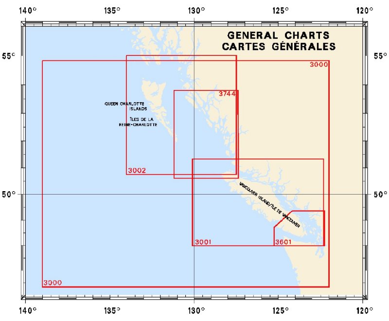
For information on general nautical charts of the Pacific Coast of Canada produced by Canadian Hydrographic Service, click an area of the index below, or see our price list to order.

Digital Charts on CD-ROM are also available for this region.

If you do not see what you are looking for, please feel free to ask us.
Please Note:
  • Charts are normally sent rolled in a tube for orders shipped within Canada and the United States. Charts sent to other countries are sent folded. If you would prefer to make alternate arrangements, please specify at the time of ordering. Charts sent rolled in a tube to the U.S. by mail usually take longer to arrive than folded orders.
  • Some charts are only available pre-folded, as indicated beside the chart title.
  • All charts are printed on paper and are not available in waterproof unless indicated.

 
Index to General Pacific Charts 3601 Juan de Fuca Strait to/à Vancouver Harbour 3744 Queen Charlotte Sound 3002 Queen Charlotte Sound to/à Dixon Entrance 3001 Vancouver Island/Île de Vancouver, Juan de Fuca Strait to/à Queen Charlotte Soun 3000 Juan de Fuca Straite to/à Dixon Entrance
Chart Number Name Scale Price  
3000 Juan de Fuca Straite to Dixon Entrance 1:1,250,000 $20.00
3001 Vancouver Island, Juan de Fuca Strait to Queen Charlotte Sound 1:525,000 $20.00
3002 Queen Charlotte Sound to Dixon Entrance 1:525,000 $20.00
3601 Juan de Fuca Strait to Vancouver Harbour 1:200,000 $20.00
3744 Queen Charlotte Sound 1:365,100 $20.00

Related Sections:
  Pacific Chart Index
  Pacific General Charts
  Pacific Small Craft Charts
  North Coast of B.C.
  South Coast of B.C.
  Large Scale North B.C.
  Large Scale North Vancouver Island
  Large Scale South Vancouver Island
  Queen Charlotte Islands
  Charts on CD-ROM

Browse By Type of Map:
  Topographic Maps
  Nautical Charts
  Aeronautical Charts
  Depth Maps and Charts
  Recreation Maps
  Park Maps
  Backroad Mapbooks
  Digital Topographic Maps

Browse By Region:
  Canada
  Alberta
  British Columbia
  Manitoba
  New Brunswick
  Newfoundland
  Northwest Territories
  Nova Scotia
  Nunavut
  Ontario
  Prince Edward Island
  Quebec
  Saskatchewan
  Yukon
Featured Areas:
  Algonquin
  Killarney
  Temagami
  Banff
  Jasper
Outside Canada:
  Maps of the World
  North America

Related Reading:
  Boating in Canada
  Sailing Directions
  West Coast Cruising Guides and Chart Books
  List of Lights
  Radio Aids
  Tide and Current Tables
Price and availability subject to change. Shipping and applicable taxes extra.

Can't find what you're looking for? Try the search button at the top of the page.
Questions about anything on this page? Please e-mail us.

Information on this page last updated: April 26, 2012

What's New · Home · Search · Books on Canada · Canadian Maps and Charts · Ordering · Contact Us
©Federal Publications Inc., 1998 - 2016
425 University Avenue, Ste. 401, Toronto, Ontario, Canada M5G 1T6
Phone: (416) 860-1611 or toll-free 1-888-433-3782 · E-mail: info@fedpubs.com