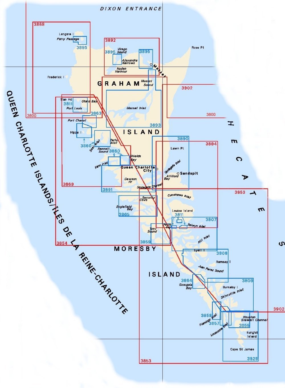
Federal Publications logo FEDERAL
PUBLICATIONS
INC.

Navigation Bar Contact Us Canadian Maps and Charts Books on Canada Home

Nautical Charts for the Queen Charlotte Islands

For information on charts for the Queen Charlotte Islands produced by Canadian Hydrographic Service, click an area of the index below, or see our price list to order.

Digital Charts on CD-ROM are also available for this region.

If you do not see what you are looking for, please feel free to ask us.
Please Note:
  • Charts are normally sent rolled in a tube for orders shipped within Canada and the United States. Charts sent to other countries are sent folded. If you would prefer to make alternate arrangements, please specify at the time of ordering. Charts sent rolled in a tube to the U.S. by mail usually take longer to arrive than folded orders.
  • Some charts are only available pre-folded, as indicated beside the chart title.
  • All charts are printed on paper and are not available in waterproof unless indicated.

 
Chart Index of the Queen Charlotte Islands 3858 Flamingo Inlet 3857 Louscoone Inlet 3864 Gowgaia Bay 3863 Port Chanal 3811 Harbours in Queen Charlotte Islands 3811 Harbours in Queen Charlotte Islands 3811 Harbours in Queen Charlotte Islands 3811 Harbours in Queen Charlotte Islands 3895 Plans - Dixon Entrance 3895 Plans - Dixon Entrance 3895 Plans - Dixon Entrance 3855 Houston Stewart Channel 3859 Tasu Sound 3860 Harbours on the West Coast of Graham Island 3860 Harbours on the West Coast of Graham Island 3860 Harbours on the West Coast of Graham Island 3860 Harbours on the West Coast of Graham Island 3865 Englefield Bay and Vicinity 3809 Carpenter Bay to/à Burnaby Island 3808 Juan Perez Sound 3807 Atli Inlet to/à Selwyn Inlet 3893 Masset Inlet 3892 Masset Harbour and/et Naden Harbour 3891 Skidegate Channel 3890 Approaches to/Approches à Skidegate Inlet 3825 Cape St. James to/à Houston Stewart Channel 3869 Skidgate Channel to/à Tian Rock 3868 Port Louis to Langara Island 3894 Selwyn Inlet to/à Lawn Point 3854 Tasu Sound to/à Port Louis 3853 Cape St. James to/à Cumshewa Inlet and/et Tasu Sound 3902 Hecate Strait 3800 Dixon Entrance

Chart Number Name Scale Price  
3800 Dixon Entrance 1:200,000 $20.00
3807 Atli Inlet to Selwyn Inlet 1:37,500 $20.00
3808 Juan Perez Sound 1:37,500 $20.00
3809 Carpenter Bay to Burnaby Island 1:37,500 $20.00
3811 Harbours in Queen Charlotte Islands
-Thurston Harbour
-Pacofi Bay
-Rockfish Harbour
-Port Louis and Otard Bay

1:18,300
1:12,200
1:18,300
1:18,200
$20.00
3825 Cape St. James to Houston Stewart Channel 1:40,000 $20.00
3853 Cape St. James to Cumshewa Inlet and Tasu Sound 1:150,000 $20.00
3854 Tasu Sound to Port Louis 1:141,900 $20.00
3855 Houston Stewart Channel 1:20,000 $20.00
3857 Louscoone Inlet 1:18,300 $20.00
3858 Flamingo Inlet 1:18,200 $15.00
3859 Tasu Sound 1:24,300 $20.00
3860 Harbours on the West Coast of Graham Island
-Kano Inlet
-Seal and Tartu Inlets
-Hippa Island
-Rennels Sound, Shields Bay

1:36,500
1:36,500
1:36.500
1:18,300
$20.00
3863 Port Chanal 1:18,300 $15.00
3864 Gowgaia Bay 1:18,300 $15.00
3865 Englefield Bay and Vicinity
-Security Cove
1:36,600
1:18,300
$20.00
3868 Port Louis to Langara Island 1:72,900 $20.00
3869 Skidgate Channel to Tian Rock 1:70,600 $20.00
3890 Approaches to Skidegate Inlet
-Aliford Bay
-Queen Charlotte
1:40,000
1:10,000
1:10,000
$20.00
3891 Skidegate Channel
-East Narrows and West Narrows
1:40,000
1:10,000
$20.00
3892 Masset Harbour and Naden Harbour
-Wiah Point
1:40,000
1:20,000
$20.00
3893 Masset Inlet
-Juskatla Narrows
1:40,000
1:12,000
$20.00
3894 Selwyn Inlet to Lawn Point 1:73,000 $20.00
3895 Plans - Dixon Entrance
-Alexandra Narrows
-Masset Harbour and Approaches
-Parry Passage
1:20,000 $20.00
3902 Hecate Strait 1:250,000 $20.00

Related Sections:
  Pacific Chart Index
  Pacific General Charts
  Pacific Small Craft Charts
  North Coast of B.C.
  South Coast of B.C.
  Large Scale North B.C.
  Large Scale North Vancouver Island
  Large Scale South Vancouver Island
  Queen Charlotte Islands
  Charts on CD-ROM

Browse By Type of Map:
  Topographic Maps
  Nautical Charts
  Aeronautical Charts
  Depth Maps and Charts
  Recreation Maps
  Park Maps
  Backroad Mapbooks
  Digital Topographic Maps

Browse By Region:
  Canada
  Alberta
  British Columbia
  Manitoba
  New Brunswick
  Newfoundland
  Northwest Territories
  Nova Scotia
  Nunavut
  Ontario
  Prince Edward Island
  Quebec
  Saskatchewan
  Yukon
Featured Areas:
  Algonquin
  Killarney
  Temagami
  Banff
  Jasper
Outside Canada:
  Maps of the World
  North America

Related Reading:
  Hiking
  Paddling
  Outdoor Activities
  Nature Watching
  Travel in Western and Northern Canada
Price and availability subject to change. Shipping and applicable taxes extra.

Can't find what you're looking for? Try the search button at the top of the page.
Questions about anything on this page? Please e-mail us.

Information on this page last updated: April 26, 2012

What's New · Home · Search · Books on Canada · Canadian Maps and Charts · Ordering · Contact Us
©Federal Publications Inc., 1998 - 2016
425 University Avenue, Ste. 401, Toronto, Ontario, Canada M5G 1T6
Phone: (416) 860-1611 or toll-free 1-888-433-3782 · E-mail: info@fedpubs.com