| Chart Number |
Name |
Scale |
Price |
|
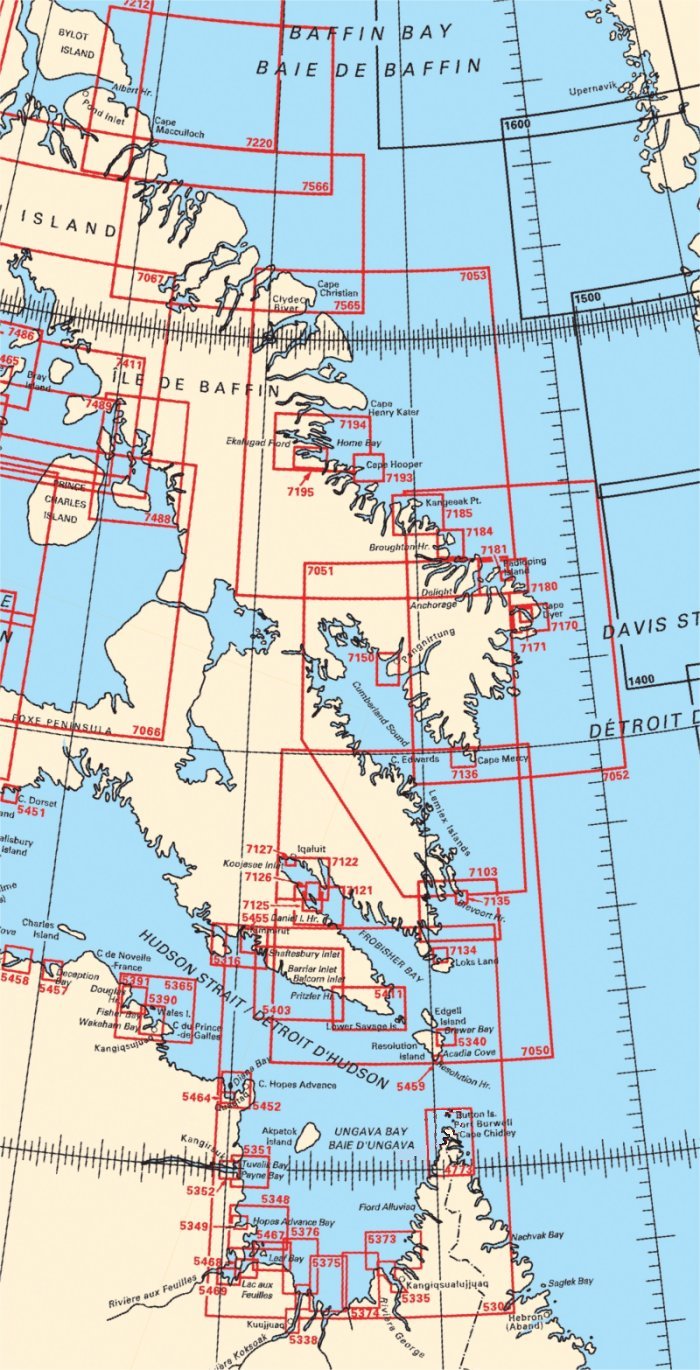
| 4773 |
Vicinity of Cape
Chidley |
1:100 000 |
$20.00 |
 |
| 5300 |
Ungava Bay |
1:500 000 |
$20.00 |
|
| 5316 |
Shaftesbury Inlet
to Ashe Inlet |
1:75 000 |
$20.00 |
|
| 5335 |
Rivière
George |
1:30 000 |
$20.00 |
|
| 5338 |
Rivière
Koksoak |
1:30 000 |
$20.00 |
|
| 5340 |
Approach to Sorry
Harbor |
1:25 000 |
$20.00 |
|
| 5348 |
Approaches to
Hopes Advance Bay |
1:75 000 |
$20.00 |
|
| 5349 |
Hopes Advance Bay
|
1:24 000 |
$20.00 |
|
| 5351 |
Payne Bay and
Approaches |
1:50 000 |
$20.00 |
|
| 5352 |
Payne Bay and
River (Tuvalik Point to Basking Island) |
1:30 000 |
$20.00 |
|
| 5365 |
Cape Prince of
Wales to Davies Island |
1:100 000 |
$20.00 |
|
| 5373 |
Approaches to
Rivière George |
1:60 000 |
$20.00 |
|
| 5374 |
Beacon Island to
Qikirtaaluk Islands |
1:60 000 |
$20.00 |
|
| 5375 |
Qikirtaaluk
Islands to Point Qirniraujaq |
1:60 000 |
$20.00 |
|
| 5376 |
Approaches to
Rivière Koksoak |
1:60 000 |
$20.00 |
|
| 5390 |
Wakeham and
Fishers Bay and Approaches |
1:37 500 |
$20.00 |
|
| 5391 |
Douglas Harbour
and Approaches |
1:37 500 |
$20.00 |
|
| 5403 |
Pritzler Harbour
to Maniittur Cape |
1:136 179 |
$20.00 |
|
| 5411 |
Lower Savage
Islands to Pritzler Harbour |
1:137 520 |
$15.00 |
|
| 5452 |
Diana Bay |
1:50 000 |
$20.00 |
|
| 5455 |
Kimmirut and
Approaches |
1:25 000 |
$20.00 |
|
| 5457 |
Deception Bay
|
1:25 000 |
$20.00 |
|
| 5458 |
Sugluk Inlet |
1:25 000 |
$20.00 |
|
| 5459 |
Resolution Harbour
and Acadia Cove |
1:12 000 |
$20.00 |
|
| 5464 |
Diana Bay
(Southern Portion) |
1:20 000 |
$20.00 |
|
| 5467 |
Leaf Bay and
Approaches |
1:50 000 |
$20.00 |
|
| 5468 |
Passage aux
Feuilles |
1:30 000 |
$20.00 |
|
| 5469 |
Lac aux Feuilles
|
1:30 000 |
$20.00 |
|
| 7050 |
Resolution Island
to Cape Mercy |
1:500 000 |
$20.00 |
|
| 7051 |
Cumberland Sound
|
1:500 000 |
$20.00 |
|
| 7052 |
Cape Mercy to
Kangeeak Point |
1:500 000 |
$20.00 |
|
| 7053 |
Padloping Island
to Clyde Inlet |
1:500 000 |
$20.00 |
|
| 7103 |
Approaches to
Brevoort Harbour |
1:150 000 |
$20.00 |
|
| 7121 |
Cape Mills to Cape
Rammelsberg |
1:75 000 |
$20.00 |
|
| 7122 |
Culbertson Island
to Koojesse Inlet |
1:75 000 |
$20.00 |
|
| 7125 |
Pike-Resor Channel
|
1:37 500 |
$20.00 |
|
| 7126 |
Culbertson Island
to Frobisher's Farthest |
1:25 000 |
$20.00 |
|
| 7127 |
Koojesse Inlet and
Approaches |
1:40 000 |
$20.00 |
|
| 7134 |
Robinson Bay and
Approaches |
1:30 000 |
$20.00 |
|
| 7135 |
Brevoort Harbour
|
1:12 000 |
$20.00 |
|
| 7136 |
Cape Mercy and
Approaches |
1:30 000 |
$20.00 |
|
| 7150 |
Pangnirtung |
1:36 585 |
$20.00 |
|
| 7170 |
Exeter Bay and
Approaches |
1:50 000 |
$20.00 |
|
| 7171 |
Exeter Bay Landing
Beach |
1:12 500 |
$20.00 |
|
| 7180 |
Padloping Island
and Approaches |
1:65 000 |
$20.00 |
|
| 7181 |
Durban Harbour
|
1:12 500 |
$20.00 |
|
| 7184 |
Broughton Island
and Approaches |
1:50 000 |
$20.00 |
|
| 7185 |
Kangeeak Point and
Approaches |
1:50 000 |
$20.00 |
|
| 7193 |
Cape Hooper and
Approaches |
1:60 000 |
$20.00 |
|
| 7194 |
Cape Hooper To
Arguyartu Point Including Ekalugad Fiord |
1:125 000 |
$20.00 |
|
| 7195 |
Kangok Fiord and
Approaches |
1:40 000 |
$20.00 |
|
| 7565 |
Clyde Inlet to
Cape Jameson |
1:300 000 |
$20.00 |
|
| 7566 |
Cape Jameson to
Cape Fanshawe |
1:300 000 |
$20.00 |
|