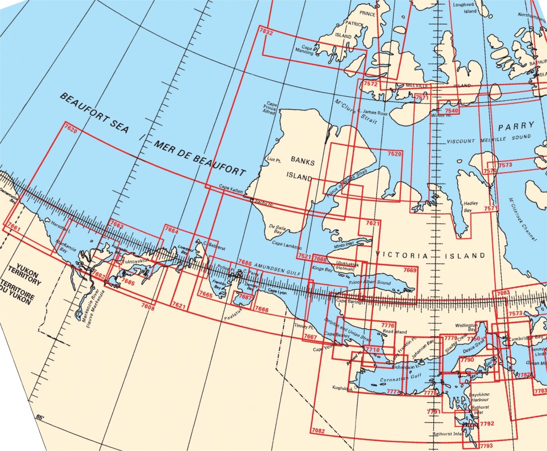
Federal Publications logo FEDERAL
PUBLICATIONS
INC.

Navigation Bar Checkout View Cart Contact Us Canadian Maps and Charts Books on Canada Home

Nautical Charts of Beaufort Sea

Looking for charts of the Beaufort Sea? See below for an index to charts produced by Canadian Hydrographic Service - order information appears below the map.

If you do not see what you are looking for, please feel free to ask us.
Please Note:
  • Charts are normally sent rolled in a tube for orders shipped within Canada and the United States. Charts sent to other countries are sent folded. If you would prefer to make alternate arrangements, please specify at the time of ordering. Charts sent rolled in a tube to the U.S. by mail usually take longer to arrive than folded orders.
  • Some charts are only available pre-folded, as indicated beside the chart title. These charts are only available folded, not rolled.
  • All charts are on paper, and not available in waterproof unless indicated.

 
Queen Elizabeth Islands Index Parry Channel to Foxe Basin Index Queen Maud Gulf Western Portion Cape Baring to Cambridge Bay Cape Baring to Cambridge Bay Cape Baring to Cambridge Bay Bathurst Inlet - Southern Portion Bathurst Inlet - Central Portion Bathurst Inlet - Northern Portion Melville Sound Dease Strait Approaches to Cambridge Bay Coronation Gulf Eastern Portion Coronation Gulf Western Portion Dolphin and Union Strait Lambert Channel and Cache Point Channel Viscount Melville Sound Amundsen Gulf Amundsen Gulf Demarcation Bay to Liverpool Bay Demarcation Bay to Philips Bay Kugmallit Bay Mackenzie Bay Eskimo Lakes Tuktoyaktuk Harbour and Approaches Liverpool Bay Franklin Bay and Darnley Bay Approaches to Paulatuk Harbour Police Point And Approaches Cape Lyon to Tinney Point Dolphin and Union Strait To Prince Albert Sound Prince Albert Sound, Western Portion Prince Albert Sound Eastern Portion Bridport Inlet and Approaches Bridport Inlet and Approaches Prince of Wales Strait, Southern Portion Prince of Wales Strait, Northern Portion Eglington Island to Cape Kellett
Chart Number Name Scale Price  
7082 Cape Baring to Cambridge Bay 1:500 000 $20.00 Add to Cart
7520 Prince of Wales Strait, Northern Portion 1:200 000 $20.00 Add to Cart
7521 Prince of Wales Strait, Southern Portion 1:200 000 $20.00 Add to Cart
7571 Viscount Melville Sound 1:300 000 $20.00 Add to Cart
7572 Viscount Melville Sound and M'clure Strait 1:300 000 $20.00 Add to Cart
7608 Eskimo Lakes 1:150 000 $20.00 Add to Cart
7620 Demarcation Bay to Liverpool Bay 1:500 000 $20.00 Add to Cart
7621 Amundsen Gulf 1:500 000 $20.00 Add to Cart
7661 Demarcation Bay to Philips Bay 1:150 000 $20.00 Add to Cart
7662 Mackenzie Bay 1:150 000 $20.00 Add to Cart
7663 Kugmallit Bay 1:150 000 $20.00 Add to Cart
7664 Liverpool Bay 1:150 000 $20.00 Add to Cart
7665 Franklin Bay and Darnley Bay 1:150 000 $20.00 Add to Cart
7666 Cape Lyon to Tinney Point 1:150 000 $20.00 Add to Cart
7667 Dolphin and Union Strait To Prince Albert Sound 1:150 000 $20.00 Add to Cart
7668 Prince Albert Sound, Western Portion 1:150 000 $20.00 Add to Cart
7669 Prince Albert Sound Eastern Portion 1:150 000 $20.00 Add to Cart
7685 Tuktoyaktuk Harbour and Approaches 1:15 000 $20.00 Add to Cart
7686 Police Point And Approaches 1:50 000 $20.00 Add to Cart
7687 Approaches to Paulatuk Harbour 1:50 000 $20.00 Add to Cart
7710 Lambert Channel and Cache Point Channel 1:80 000 $20.00 Add to Cart
7750 Approaches to Cambridge Bay 1:80 000 $20.00 Add to Cart
7776 Dolphin and Union Strait 1:150 000 $20.00 Add to Cart
7777 Coronation Gulf Western Portion 1:150 000 $20.00 Add to Cart
7778 Coronation Gulf Eastern Portion 1:150 000 $20.00 Add to Cart
7779 Dease Strait 1:150 000 $20.00 Add to Cart
7782 Queen Maud Gulf Western Portion 1:150 000 $20.00 Add to Cart
7790 Melville Sound 1:100 000 $20.00 Add to Cart
7791 Bathurst Inlet - Northern Portion 1:100 000 $20.00 Add to Cart
7792 Bathurst Inlet - Central Portion 1:60 000 $20.00 Add to Cart
7793 Bathurst Inlet - Southern Portion 1:60 000 $20.00 Add to Cart
7832 Eglington Island to Cape Kellett 1:500 000 $20.00 Add to Cart

Related Sections:
  Arctic Chart Index
  General Arctic Charts
  Hudson Bay Charts
  Davis Strait Charts
  Queen Elizabeth Islands Charts
  Parry Channel to Foxe Basin Charts
  Great Bear Lake Charts
  Great Slave Lake Charts
  Lake Athabasca Charts
  Mackenzie Delta Charts
  Mackenzie River Charts
Browse By Type of Map:
  Topographic Maps
  Nautical Charts
  Aeronautical Charts
  Depth Maps and Charts
  Recreation Maps
  Park Maps
  Backroad Mapbooks
  Digital Topographic Maps

Browse By Region:
  Canada
  Alberta
  British Columbia
  Manitoba
  New Brunswick
  Newfoundland
  Northwest Territories
  Nova Scotia
  Nunavut
  Ontario
  Prince Edward Island
  Quebec
  Saskatchewan
  Yukon
Featured Areas:
  Algonquin
  Killarney
  Temagami
  Banff
  Jasper
Outside Canada:
  Maps of the World
  North America

Related Reading:
  Boating in Canada
  Sailing Directions
  List of Lights
  Radio Aids
  Tide and Current Tables
Price and availability subject to change. Shipping and applicable taxes extra.

Can't find what you're looking for? Try the search button at the top of the page.
Questions about anything on this page? Please e-mail us.

Information on this page last updated: April 19, 2011

What's New · Home · Search · Books on Canada · Canadian Maps and Charts · Ordering · Contact Us
©Federal Publications Inc., 1998 - 2016
425 University Avenue, Ste. 401, Toronto, Ontario, Canada M5G 1T6
Phone: (416) 860-1611 or toll-free 1-888-433-3782 · E-mail: info@fedpubs.com