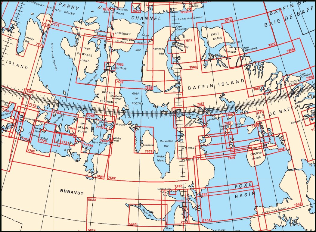
Federal Publications logo FEDERAL
PUBLICATIONS
INC.

Navigation Bar Checkout View Cart Contact Us Canadian Maps and Charts Books on Canada Home

Nautical Charts of Parry Channel to Foxe Basin

Looking for general nautical charts from Parry Channel to Foxe Basin? See below for an index to charts produced by Canadian Hydrographic Service - order information appears below the map.

If you do not see what you are looking for, please feel free to ask us.
Please Note:
  • Charts are normally sent rolled in a tube for orders shipped within Canada and the United States. Charts sent to other countries are sent folded. If you would prefer to make alternate arrangements, please specify at the time of ordering. Charts sent rolled in a tube to the U.S. by mail usually take longer to arrive than folded orders.
  • Some charts are only available pre-folded, as indicated beside the chart title. These charts are only available folded, not rolled.
  • All charts are on paper, and not available in waterproof unless indicated.

 
Beaufort Sea Index Davis Strait Index Hudson Bay Index Barrow Strait and Viscount Melville Sound Lancaster Sound, Eastern Approaches M'Clintock Channel, Larsen Sound and Franklin Strait Lancaster Sound and Admiralty Inlet Clyde Inlet to Cape Jameson Cape Jameson to Cape Fanshawe Bylot Island and Adjacent Channels Cape Dorchester to Spicer Islands Winter Island to Cape Jermain Frozen Strait, Lyon Inlet and Approaches Peel Sound and Prince Regent Inlet Gulf of Boothia and Committee Bay Strathcona Sound and Adams Sound Bellot Strait and Approaches Cambridge Bay to Shepherd Bay Cambridge Bay to Shepherd Bay Queen Maud Gulf Western Portion Victoria Strait Queen Maud Gulf Eastern Portion Requisite Channel and Approaches Storis Passage and Approaches Spicer Islands to West Entrance of Fury and Hecla Strait Spicer Islands to Longstaff Bluff Air Force Island to Longstaff Bluff Navy Channel to Longstaff Bluff Fury and Hecla Strait Navy Channel to Fury and Hecla Strait St. Roch and Rasmussen Basins Spence Bay and Approaches Pelly Bay McClintock Bay and Wilkins Point Simpson Strait McClintock Bay and Wilkins Point Repulse Bay and Approaches Frustration Bay and Approaches Parry Bay to Navy Channel Repulse Bay Harbours Islands to Talun Bay Wager Bay
Chart Number Name Scale Price  
5440 Wager Bay 1:200 000 $20.00 Add to Cart
7066 Cape Dorchester to Spicer Islands 1:500 000 $20.00 Add to Cart
7067 Spicer Islands to West Entrance of Fury and Hecla Strait 1:500 000 $20.00 Add to Cart
7083 Cambridge Bay to Shepherd Bay 1:500 000 $20.00 Add to Cart
7212 Bylot Island and Adjacent Channels 1:250 000 $20.00 Add to Cart
7220 Lancaster Sound, Eastern Approaches 1:500 000 $20.00 Add to Cart
7404 Frozen Strait, Lyon Inlet and Approaches 1:200 000 $20.00 Add to Cart
7405 Repulse Bay and Approaches 1:200 000 $20.00 Add to Cart
7411 Spicer Islands to Longstaff Bluff 1:200 000 $20.00 Add to Cart
7430 Repulse Bay Harbours Islands to Talun Bay 1:31 700 $20.00 Add to Cart
7465 Frustration Bay and Approaches 1:25 000 $20.00 Add to Cart
7482 Winter Island to Cape Jermain 1:300 000 $20.00 Add to Cart
7485 Parry Bay to Navy Channel 1:150 000 $20.00 Add to Cart
7486 Navy Channel to Fury and Hecla Strait 1:150 000 $20.00 Add to Cart
7487 Fury and Hecla Strait 1:150 000 $20.00 Add to Cart
7488 Air Force Island to Longstaff Bluff 1:150 000 $20.00 Add to Cart
7489 Navy Channel to Longstaff Bluff 1:150 000 $20.00 Add to Cart
7502 Gulf of Boothia and Committee Bay 1:500 000 $20.00 Add to Cart
7512 Strathcona Sound and Adams Sound 1:80 000 $20.00 Add to Cart
7552 Bellot Strait and Approaches 1:50 000 $20.00 Add to Cart
7565 Clyde Inlet to Cape Jameson 1:300 000 $20.00 Add to Cart
7566 Cape Jameson to Cape Fanshawe 1:300 000 $20.00 Add to Cart
7568 Lancaster Sound and Admiralty Inlet 1:300 000 $20.00 Add to Cart
7570 Barrow Strait and Viscount Melville Sound 1:300 000 $20.00 Add to Cart
7573 M'Clintock Channel, Larsen Sound and Franklin Strait 1:500 000 $20.00 Add to Cart
7575 Peel Sound and Prince Regent Inlet 1:300 000 $20.00 Add to Cart
7578 Pelly Bay 1:125 000 $20.00 Add to Cart
7646 McClintock Bay and Wilkins Point 1:12 000 $11.50 Add to Cart
7725 Requisite Channel and Approaches 1:75 000 $20.00 Add to Cart
7731 Storis Passage and Approaches 1:75 000 $20.00 Add to Cart
7736 Simpson Strait 1:25 000 $20.00 Add to Cart
7760 St. Roch and Rasmussen Basins 1:200 000 $20.00 Add to Cart
7770 Spence Bay and Approaches 1:50 000 $20.00 Add to Cart
7782 Queen Maud Gulf Western Portion 1:150 000 $20.00 Add to Cart
7783 Queen Maud Gulf Eastern Portion 1:150 000 $20.00 Add to Cart
7784 Victoria Strait 1:150 000 $20.00 Add to Cart

Related Sections:
  Arctic Chart Index
  General Arctic Charts
  Hudson Bay Charts
  Beaufort Sea Charts
  Davis Strait Charts
  Queen Elizabeth Islands Charts
  Great Bear Lake Charts
  Great Slave Lake Charts
  Lake Athabasca Charts
  Mackenzie Delta Charts
  Mackenzie River Charts
Browse By Type of Map:
  Topographic Maps
  Nautical Charts
  Aeronautical Charts
  Depth Maps and Charts
  Recreation Maps
  Park Maps
  Backroad Mapbooks
  Digital Topographic Maps

Browse By Region:
  Canada
  Alberta
  British Columbia
  Manitoba
  New Brunswick
  Newfoundland
  Northwest Territories
  Nova Scotia
  Nunavut
  Ontario
  Prince Edward Island
  Quebec
  Saskatchewan
  Yukon
Featured Areas:
  Algonquin
  Killarney
  Temagami
  Banff
  Jasper
Outside Canada:
  Maps of the World
  North America

Related Reading:
  Boating in Canada
  Sailing Directions
  List of Lights
  Radio Aids
  Tide and Current Tables
Price and availability subject to change. Shipping and applicable taxes extra.

Can't find what you're looking for? Try the search button at the top of the page.
Questions about anything on this page? Please e-mail us.

Information on this page last updated: April 19, 2011

What's New · Home · Search · Books on Canada · Canadian Maps and Charts · Ordering · Contact Us
©Federal Publications Inc., 1998 - 2016
425 University Avenue, Ste. 401, Toronto, Ontario, Canada M5G 1T6
Phone: (416) 860-1611 or toll-free 1-888-433-3782 · E-mail: info@fedpubs.com