| Chart Number |
Name |
Scale |
Price |
|
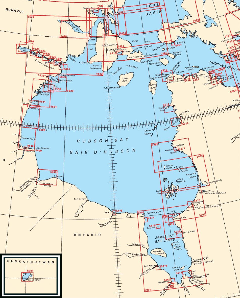
| 5365 |
Cape Prince of
Wales to Davies Island |
1:100 000 |
$20.00 |
 |
| 5390 |
Wakeham and
Fishers Bay and Approaches |
1:37 500 |
$20.00 |
|
| 5391 |
Douglas Harbour
and Approaches |
1:37 500 |
$20.00 |
|
| 5399 |
Egg Island to
Eskimo Point |
1:150 000 |
$20.00 |
|
| 5400 |
Cape Churchill to
Egg River |
1:146 198 |
$20.00 |
|
| 5406 |
Cape Tatnam to
Port Nelson |
1:127 000 |
$20.00 |
|
| 5410 |
Coral Harbour and
Approaches |
1:50 000 |
$20.00 |
|
| 5412 |
Erik Cove to Nuvuk
Harbour including Digges Islands |
1:75 000 |
$20.00 |
|
| 5414 |
Rupert Bay |
1:73 000 |
$20.00 |
|
| 5451 |
Cape Dorset and
Approaches |
1:25 000 |
$20.00 |
|
| 5457 |
Deception Bay
|
1:25 000 |
$20.00 |
|
| 5458 |
Sugluk Inlet |
1:37 500 |
$20.00 |
|
| 5471 |
Inukjuak and
Approaches |
1:25 000 |
$20.00 |
|
| 5476 |
Harbours and
Anchorages Hudson Bay and James Bay |
1:75 000 |
$20.00 |
|
| 5505 |
Bélanger
Island to Cotter Island |
1:250 000 |
$20.00 |
|
| 5510 |
Povungnituk and
Approches |
1:60 000 |
$20.00 |
|
| 5512 |
Smith Island to
Knight Harbour |
1:50 000 |
$20.00 |
|
| 5533 |
Roes Welcome Sound
(Chesterfield Inlet to Cape Munn) |
1:500 000 |
$20.00 |
|
| 5620 |
Entrance to
Chesterfield Inlet (Fairway Island to Ellis Island) |
1:40 000 |
$20.00 |
|
| 5621 |
Rockhouse Island
to Centre Island |
1:40 000 |
$20.00 |
|
| 5622 |
Centre Island to
Farther Hope Point |
1:40 000 |
$20.00 |
|
| 5623 |
Farther Hope Point
to Terror Point |
1:40 000 |
$20.00 |
|
| 5624 |
Terror Point to
Schooner Harbour |
1:40 000 |
$20.00 |
|
| 5625 |
Schooner Harbour
to Baker Lake |
1:40 000 |
$20.00 |
|
| 5626 |
Baker Lake |
1:80 000 |
$20.00 |
|
| 5628 |
Rankin Inlet
Including Melvin Bay And Prairie Bay |
1:15 000 |
$20.00 |
|
| 5629 |
Marble Island to
Rankin Inlet |
1:60 000 |
$20.00 |
|
| 5630 |
Dunne Foxe Island
to Chesterfield Inlet |
1:150 000 |
$20.00 |
|
| 5631 |
Eskimo Point to
Dunne Foxe Island |
1:150 000 |
$20.00 |
|
| 5640 |
Churchill Harbour
|
1:12 000 |
$20.00 |
|
| 5641 |
Arviat and
Approaches |
1:60 000 |
$20.00 |
|
| 5642 |
Whale Cove and
Approaches |
1:60 000 |
$20.00 |
|
| 5705 |
Cape Dufferin to
Broughton Island |
1:250 000 |
$20.00 |
|
| 5707 |
Bélanger
Island to Long Island |
>=1:250 000
|
$20.00 |
|
| 5720 |
Approaches to
Chisasibi |
1:30 000 |
$20.00 |
|
| 5800 |
James Bay |
1:500 000 |
$20.00 |
|
| 5801 |
Long Island to
Fort George |
1:150 000 |
$20.00 |
|
| 5860 |
Approaches to
Moose River |
1:24 000 |
$20.00 |
|
| 5861 |
Ship Sands Island
to Moosonee |
1:24 000 |
$20.00 |
|
| 6281 |
Lac La Ronge |
1:75 000 |
$20.00 |
|
| 7065 |
Mill Island to
Winter Island |
1:500 000 |
$20.00 |
|
| 7404 |
Frozen Strait,
Lyon Inlet and Approaches |
1:200 000 |
$20.00 |
|
| 7405 |
Repulse Bay and
Approaches |
1:200 000 |
$20.00 |
|
| 7430 |
Repulse Bay
Harbours Islands to Talun Bay |
1:31 700 |
$20.00 |
|
| 7481 |
Foxe Channel |
1:300 000 |
$20.00 |
|
| 7482 |
Winter Island to
Cape Jermain |
1:300 000 |
$20.00 |
|