| FEDERAL PUBLICATIONS INC. |
| |
|
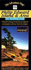
Philip Edward Island and Area Sea Kayaking Guide (Map)The Adventure Map® |
 |
||
| Format | Waterproof folded map | |
| Catalogue No. | 0-929140-36-2 | |
| Scale | 1:30,000 | |
| Language | English only | |
| Price | $12.95 | |
| Published by Chrismar Mapping Services, 2007. Description: |
| The north coast of Georgian Bay is considered to be
among the most beautiful of wild kayaking and camping experiences in North
America. This 1:30,000 scale map includes Philip Edward Island on the north shore of Georgian Bay, as well as the southern portion of Killarney Provincial Park. It covers the area from Thomas Bay a few kilometres west of Chikanishing River and the west park boundary, all the way east to Point Grondine, and from the George Lake campground in Killarney Provincial Park all the way south to the remote Scarecrow and Green islands. That's all of Philip Edward Island, Collins Inlet, Beaverstone Bay and the south edge of Killarney Provincial Park. Extraordinary geographic detail plus special features showing shallow waters, shoals, buoys, ranges, lighthouses and other nautical items are shown. It combines the most useful features of topographic maps and nautical charts. You'll also find information and great colour photographs about the geologic and natural history of the area, plus significant sections about planning your trip, route suggestions, gear guide, backcountry etiquette, safety concerns, contact information and much more. The Adventure Map® is specifically designed for outdoor adventurers such as hikers, backpackers, and paddling enthusiasts who need an accurate, up-to-date, rugged map to get them into and safely back from the wilderness. The Adventure Map® is compact (most measure 18" x 24"/45 x 61cm or less), easy to read, and easy to fold. The maps are also waterproof, printed on specially-made, extra tough, waterproof plastic. |
| Price and availability subject to change.
Shipping and applicable taxes extra. Questions about anything on this page? Please e-mail us. This page last modified: August 6, 2008 |
| Recreation Maps main page |
| What's New · Home · Search · Books on Canada · Canadian Maps and Charts · Ordering · Contact Us |
©Federal Publications Inc., 1998 - 2016 425 University Avenue, Ste. 401, Toronto, Ontario, Canada M5G 1T6 Phone: (416) 860-1611 or toll-free 1-888-433-3782 · E-mail: info@fedpubs.com |