| FEDERAL PUBLICATIONS INC. |
| |
|
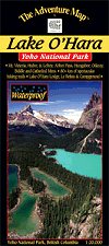
Lake O'Hara - Yoho National ParkThe Adventure Map® |
 |
||
| Format | Waterproof folded map | |
| Catalogue No. | 0-929140-39-7 | |
| Scale | 1:20,000 | |
| Language | English only | |
| Price | $8.95 | |
| Published by Chrismar Mapping Services, 2007. Description: |
| An exceptionally picturesque area within B.C.'s Yoho
National Park, and just over the continental divide from Lake
Louise. The Lake O'Hara - Yoho National Park map is your guide to over 80 km of hiking trails, alpine meadows, pristine mountain lakes, massive glaciers, and awesome vistas in a compact area well away from the hustle and bustle of this popular tourist region. This detailed 1:20,000 scale map has been adopted as the official Lake O'Hara map by the Lake O'Hara Trails Club. The Adventure Map® is specifically designed for outdoor adventurers such as hikers, backpackers, and paddling enthusiasts who need an accurate, up-to-date, rugged map to get them into and safely back from the wilderness. The Adventure Map® is compact (most measure 18" x 24"/45 x 61cm or less), easy to read, and easy to fold. The maps are also waterproof, printed on specially-made, extra tough, waterproof plastic. |
| Price and availability subject to change.
Shipping and applicable taxes extra. Questions about anything on this page? Please e-mail us. This page last modified: May 9, 2012 |
| Banff National Park main page · National Park Maps of Canada main page |
| What's New · Home · Search · Books on Canada · Canadian Maps and Charts · Ordering · Contact Us |
©Federal Publications Inc., 1998 - 2012 425 University Avenue, Ste. 401, Toronto, Ontario, Canada M5G 1T6 Phone: (416) 860-1611 or toll-free 1-888-433-3782 · E-mail: info@fedpubs.com |