As seen at:
- The Spring Cottage Life Show (Toronto)
- The Toronto Sportsmen's Show
- The Fall Cottage Life Show (Toronto)
- The Outdoor Adventure Show (Toronto)
- The Cottage Show (Ottawa)
|
|
We started offering customized maps four years ago.
Since then, thousands of customers have been thrilled with our customized maps,
made exactly to their requirements.
Federal Publications can print
customized topographic maps to cover the exact area you want. If the
pre-printed Government of Canada topographic map doesn't suit your purposes, we
can use this same data to create a customized map just for you. The scale of
the original maps is 1:50,000 but we can zoom in to focus on a small area, or
zoom out to cover a larger area. Note: zooming in will not add detail, merely
enlarge the existing image.
If your small lake is "lost" on a
full-sized topo, or perhaps your lake is split between several topo sheets, our
customized maps are perfect for you!
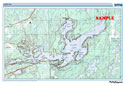
Samples: Crystal Lake and Mississippi Lake.
Sizes AvailableWe offer three
different sizes:
Small ("Placemat" size)
- A3+: 13" x 19". This is the best size if
you'd like to focus in on a small area. Printed on high-quality photo paper
with archival quality ink, which is the best choice for framing. Alternately,
we can print your map on waterproof material for use in the outdoors.
- On this size paper, we can print maps at scales from 1:15,000
(approximately 4.5 km x 6.5 km) to approximately 1:60,000 (approximately 18 km
x 26 km).
- Maps can be printed horizontally (i.e., landscape, the map is
wider than its height), or vertically (i.e., portrait, the map is taller than
its width).
- Price: $19.95, plus applicable taxes and shipping. Sent
rolled in a tube.
Medium ("Poster" size)
- 24" x 36". This is a good size if you'd
like a wall-size map. Printed on semi-gloss photo paper with archival quality
ink. Alternately, we can print your map on waterproof material for use in the
outdoors.
- On this size paper, we can print maps at scales from 1:15,000
(approximately 9 km x 13 km) to approximately 1:75,000 (approximately 43 km x
64 km). We may be able to cover a larger area for you - please ask us.
- Maps can be printed horizontally (i.e., landscape, the map is
wider than its height), or vertically (i.e., portrait, the map is taller than
its width).
- Price: $29.95, plus applicable taxes and shipping. Sent
rolled in a tube.
Large
- 42" x 42", square. This is the best size if
you'd like to cover a large area, or put a large poster on your wall. Printed
on semi-gloss photo paper with archival quality ink. Alternately, we can print
your map on waterproof material for use in the outdoors.
- On this size paper, we can print maps at scales from 1:15,000
(approximately 15 km x 15 km) to 1:100,000 (approximately 100 km x 100 km). We
may be able to cover a larger area for you - please ask us.
- These maps are square: the width is the same as the
height.
- Price: $39.95, plus applicable taxes and shipping. Sent
rolled in a tube.
Larger Sizes
Now Available: Canvas
- The front area is 18" X 24". We "gallery
wrap" the canvas onto a 1¼" deep frame. The map image that appears on
the front continues onto all sides of the frame (example). This is a finished
product and is intended to be hung unframed.
- On this size image, we can print maps at scales from 1:15,000
(approximately 6 km x 8 km) to 1:60,000 (approximately 25 km x 32 km). We may
be able to cover a larger area for you - please ask us.
- Maps can be printed
horizontally (i.e.,
landscape, the map is wider than its height), or
vertically (i.e., portrait,
the map is taller than its width).
- Price: $74.95, plus applicable taxes and shipping. Sent
packaged in a large box.
To Order As these maps are
produced for you on a custom basis, we regret that they cannot be ordered
through the shopping cart on this website. Please
e-mail or phone us
(1-888-433-3782) to discuss your requirements.
Please describe the map
you want by selecting:
- centre-point, e.g. Lake ABC. Please remember that lake names
in Ontario are not unique so we will need the name of the nearest city, town or
community and as much other information as you can provide.
- size of coverage area or approximate scale
- size of your map (see above)
- any specific locations (lakes or towns) you want to include
in the coverage area
- lat/long grid lines can be added on request
Before finalizing the order, we will e-mail you a copy of the
map image so you can confirm the map covers your chosen area.
- Once the coverage area has been confirmed, we will provide
you with a reference number to use in the Shipping Instructions field
during checkout.
- Please choose Waterproof, Photopaper or Canvas
below and remember to enter the reference number we gave you in the
Shipping Instructions field during checkout
Small - Photopaper
- Customized Topo (Softmap)
13" X 19" |
SMC19 |
$19.95 |
|
Small - Waterproof
- Customized Topo (Softmap)
13" X 19" |
SMC19POLY |
$19.95 |
|
Medium -
Photopaper - Customized Topo (Softmap)
24" X 36" |
SMC36 |
$29.95 |
|
Medium -
Waterproof - Customized Topo (Softmap)
24" X 36" |
SMC36POLY |
$29.95 |
|
Large - Photopaper
- Customized Topo (Softmap)
42" X 42" |
SMC42 |
$39.95 |
|
Large -
Waterproof - Customized Topo (Softmap)
42" X 42" |
SMC42POLY |
$39.95 |
|
Canvas - Customized Topo (Softmap)
18" x 24" |
SMC24CANVAS |
$74.95 |
|
Additional InformationThese maps are generated using Softmap software. The source data are federal
government topographic maps (see below). They show the detail of the land, not
the depths of the water.
Topo sheets have been stitched together. In
some cases, there is a difference in colours (particularly in greens) between
the map sheets. We will always alert you if there is a significant colour
difference.
Available for most areas in:
B.C., Alberta, Ontario,
Quebec and the Maritimes.
Topographic Maps
- Topographic maps show the detail of the surface of the land,
including lakes, rivers, and roads.
- Topographic maps do not show lake depths.
- Topographic maps show roads, but not road names (only numbers
of major highways), nor do they show lot lines or concession lines.
We regret, there are a few exceptions to
the areas for which we can produce a customized topo
map.
|
|
|