| |
Canada (bilingual
political map, including the Nunavut territory)
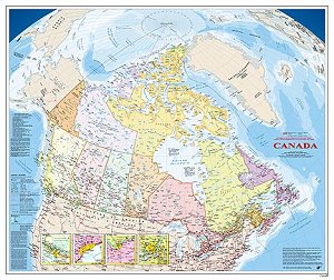 |
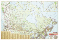
Published to recognize Canada's new political boundaries
with the creation of Nunavut. In addition, the map also shows the location and
name of each of the National Parks, and gives details on the twelve World
Heritage Sites found in Canada. It shows an extensive set of populated places,
each being shown with its name and status as of 1998, and with population
updated to the 1996 Census. The same applies to the many places in the inset
maps used for the four largest metropolitan areas. Finally, the map shows
Canada's limits - both the international boundaries as well as the boundary
delineating Canada's 200 mile fishing limit (also known as the Exclusive
Economic Zone).
Published by Natural Resources Canada, 2006.
36" x
42.8" or 91.5 cm x 108.7 cm
1:6,000,000
MCR0102
$10.75
 |
Canada Political Map -
large
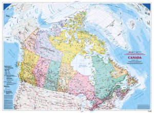 |
Paper map; bilingual; shows political divisions including
Nunavut; different colours designate provinces and territories; shows parks and
world heritage sites. Published by Natural Resources Canada, 2009.
46" x 62"
or 117cm x 157.5 cm
1:4 000 000
MCR0105
$10.75
|
Canada Relief Map
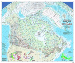 |
Canada with detailed digital shaded relief. Ocean contours
are shown using bathymetric tints. Major physical features including mountain
ranges, peaks, and spot elevations are identified.The map also shows the extent
and name for all of Canada's national parks. An extensive set of populated
places is shown, using six population size classes. All official Canadian,
provincial, and surrounding international boundaries are shown, including the
proposed boundary for the new territory of Nunavut (which came into existence
in 1999). There are three small maps of Canada shown on this map sheet, all at
scale 1: 35 000 000. One shows the major physiographic regions; the second
shows major drainage basins, and the third map shows classes of vegetation
cover. All data on the map is current to the mid to late 1990's.
Published
by Natural Resources Canada, 1998.
36" x 42.8" or 91.5 cm x 108.7 cm
1:6,000,000
MCR0101
$10.75
|
Canada - North
Circumpolar Region
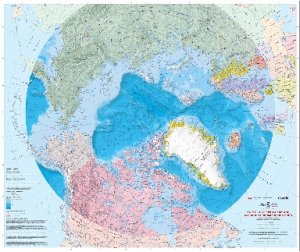 |
The North Circumpolar Region map provides a
comprehensive view of the area of Canada and the World situated between
55¼N latitude and the North Pole. Includes:
- all federal, provincial and territorial boundaries for
Canada including the Nunavut proposed boundary as well as the international
boundaries of neighbouring countries.
- major road and rail transportation networks.
- hydrography and ice cover.
- a selection of populated places along with
administrative, provincial and national capitals.
- offshore features such as ocean bathymetry, the
international date line, and Canada's exclusive fishing zone.
Published by Natural Resources Canada, 2008.
36" x
31.5" or 91.5 cm X 80 cm
1:10,000,000
MCR0001
$10.75
|
Canada Laminated
Wall Map
 |
Laminated wall map of Canada. Shows major roadways, cities,
time zones. Published by MapArt, 2008.
28" x 40"
1:5,600,000
978-1-55198-807-8
$19.95
|
|
|