| |
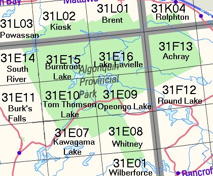 |
This index shows the topographic maps available for
Algonquin Provincial Park. Each map (e.g. 31E10) covers an area approximately
40km by 28 km (scale 1:50,000).
Some of these maps is available in 2
formats:
- Paper $11.45 each
- Tyvek (waterproof) $11.45
|
This index shows the topographic maps available for
Algonquin Provincial Park. Each map (e.g. 31E/10) covers an area approximately
40km by 28 km (scale 1:50,000).
Please
Note:
- All maps are normally sent
pre-folded. If you would prefer that we send them rolled in a tube,
please specify in the Special Handling Instructions field on our Shipping
Information page during checkout. Tyvek maps are only available
pre-folded.
- For information about waterproof
maps click here.
- For information about Tyvek maps
click here.
|
| Map Number |
Scale |
Name |
Paper
$11.45 |
Waterproof
$15.95 |
Tyvek®
$11.45
|
| 031E01 |
1:50,000 |
Wilberforce |
 |
|
Not Available |
| 031E07 |
1:50,000 |
Kawagama Lake |
|
|
Not Available |
| 031E08 |
1:50,000 |
Whitney |
|
|
Not Available |
| 031E09 |
1:50,000 |
Opeongo Lake |
|
|
Not Available |
| 031E10 |
1:50,000 |
Tom Thomson Lake |
|
|
Not Available |
| 031E11 |
1:50,000 |
Burk's Falls |
|
|
Not Available |
| 031E14 |
1:50,000 |
South River |
|
|
|
| 031E15 |
1:50,000 |
Burntroot Lake |
|
|
Not Available |
| 031E16 |
1:50,000 |
Lake Lavielle |
|
|
Not Available |
| 31F12 |
1:50,000 |
Round Lake |
|
|
Not Available |
| 31F13 |
1:50,000 |
Achray |
|
|
Not Available |
| 31L01 |
1:50,000 |
Brent |
|
|
Not Available |
| 31L02 |
1:50,000 |
Kiosk |
|
|
|
| 31L03 |
1:50,000 |
Powassan |
|
|
|
Not sure which map covers the exact
place you're looking for?
Ask us or
try the
on-line "search by map number, place name, or coordinates"
website.
Back to
Algonquin Park Maps and Books page
|
|