| FEDERAL PUBLICATIONS INC. |
| |
|
S-57 Electronic Navigation Charts on CD-ROM: Vancouver Island East |
| Catalogue No. | PAC-A | |
| Price | $599.95 | |
| Format | CD-ROM | |
| Language | Bilingual | |
Published by Canadian Hydrographic Service, 2010. |
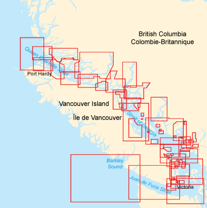 |
Description:This CD-ROM, produced by Canadian Hydrographic Service, contains digital charts for the east coast of Vancouver Island. Charts are in S-57 format.Contains the following charts: 3000, 3001, 3410, 3411, 3412, 3419, 3424, 3440, 3441, 3442, 3443, 3447, 3459, 3461, 3462, 3463, 3473, 3475, 3477, 3478, 3479, 3481, 3490, 3491, 3492, 3493, 3494, 3495, 3512, 3513, 3514, 3515, 3526, 3527, 3534, 3535, 3536, 3537, 3538, 3539, 3540, 3541, 3542, 3543, 3544, 3545, 3546, 3547, 3548, 3549, 3550, 3552, 3559, 3564, 3598, 3602, 3606 Please Note: this product does not contain navigation software. All purchases of software are final. More information can be found in our Return Policy. Please see our on-line index if you would prefer paper charts for the Central region. |
| Price and availability subject to change. Shipping and applicable taxes extra. Questions about this product? Please e-mail us. This page last modified: April 19, 2011 |
| CHS S-57 ENCs on CD-ROM main page |
| What's New · Home · Search · Books on Canada · Canadian Maps and Charts · Ordering · Contact Us |
©Federal Publications Inc., 1998 - 2011 425 University Avenue, Ste. 401, Toronto, Ontario, Canada M5G 1T6 Phone: (416) 860-1611 or toll-free 1-888-433-3782 · E-mail: info@fedpubs.com |