| FEDERAL PUBLICATIONS INC. |
| |
|
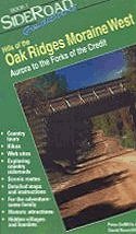
Hills of the Oak Ridges Moraine West: Aurora to the Forks of the Credit(SideRoad GuideBooks 1) |
 |
||
| Format | Stapled Softcover | |
| Catalogue No. | 0-9686805-0-X | |
| Pages | 22 | |
| Language | English only | |
| Price | $5.95 | |
Written by Peter DeMille and David Rawcliffe. Published by RawMille Publications, 2000. Description: |
| Want to gain enough
confidence to turn off the beaten track? Then turn to SideRoad GuideBooks for
inspiration. These self-directed guides are designed for people wishing to
experience the beauty and charm of rural Ontario. The books are small enough to
keep in your glove compartment. Each GuideBook includes pictures and tourist information about the countryside travelled through. While all tours start and finish in towns or at major intersections, you decide whether to complete the suggested tour in one day or do only part of the journey. Designed for a driver and a navigator, your confidence to explore will develop through the use of the Guidebook's handy Number System. Numbers appear both in driving instructions and on the map. Each number refers to the same intersection. Thus the driving instructions in the text are united with the maps. With any Number you will be provided with:
Table of Contents:
|
|
 |
|
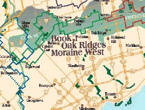
Background information: The Oak Ridges Moraine is a 150 km long ridge reaching a height of 125 metres (425 feet). It runs from the Niagara Escarpment to eastern Lake Ontario in the county of Northumberland. A Moraine is made from material deposited at the side or terminus of a glacier or ice sheet. The Oak Ridges moraine was created between two lobes of ice, one to the north and one pushing westward along the valley of lakes Ontario and Erie. In the Moraine there are several kettle lakes; these were formed where large chunks of ice were entrapped in the glacial deposits after the glaciers had receded. The sediments of the Moraine are an important means of naturally purifying our water supply. |
|
SideRoad GuideBooks series: Hills of the Oak Ridges Moraine East: Aurora to the Ganaraska Forest Niagara Escarpment SideRoads: Orangeville to Bruce Peninsula Niagara Escarpment SideRoads: Orangeville to Hamilton SideRoads to Cottage Country: Simcoe, Kawarthas, Haliburton, Muskoka, Huronia |
| Price and availability subject to change.
Shipping and applicable taxes extra. Questions about this product? Please e-mail us. This page last modified: October 6, 2010 |
| Travel in Ontario main page |
| What's New · Home · Search · Books on Canada · Canadian Maps and Charts · Ordering · E-mail Us |
©Federal Publications Inc., 1998 - 2010 425 University Avenue, Ste. 401, Toronto, Ontario, Canada M5G 1T6 Phone: (416) 860-1611 or toll-free 1-888-433-3782 · E-mail: info@fedpubs.com |