| FEDERAL PUBLICATIONS INC. |
| |
|
SoftMap Quebec topo50: Volume 3 - Southern Quebec |
 |
||
| Format | CD-ROM | |
| Catalogue No. | 1-894610-04-9 | |
| Language | Bilingual | |
| Price | $19.95 | |
| Also available: Set of all 5 Quebec volumes for $69.95 Published by SoftMap Publishing, 2001. Description: |
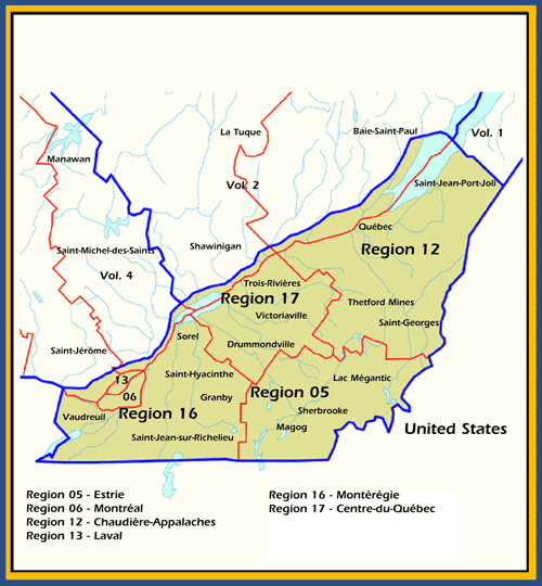
| Quebec topo50: Volume 3 – Southern Quebec is a 4-CD
package containing detailed topographic maps of southern Quebec at scales of
1:250 000 and 1:50 000. Covers the Administrative Regions of Estrie, Montreal,
Chaudière-Appalaches, Laval, Montérégie,
Centre-du-Québec, and the Félix-Leclerc highway
corridor. |
 |
| Operates on Version 4 software. Features:
All purchases of software are final. More information can be found in our Return Policy. |
| Price and availability subject to change.
Shipping and applicable taxes extra. Questions about anything on this page? Please e-mail us. This page last modified: April 19, 2011 |
| Topographic Maps on CD-ROM main page |
| What's New · Home · Search · Books on Canada · Canadian Maps and Charts · Ordering · Contact Us |
©Federal Publications Inc., 1998 - 2011 425 University Avenue, Ste. 401, Toronto, Ontario, Canada M5G 1T6 Phone: (416) 860-1611 or toll-free 1-888-433-3782 · E-mail: info@fedpubs.com |