| FEDERAL PUBLICATIONS INC. |
| |
|
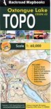
Oxtongue Lake Topographic Map |
 |
||
| Format | Folded map | |
| Catalogue No. | CEON42 | |
| Scale | 1:60,000 | |
| Language | English only | |
| Price on sale | $7.50 (reduced from $12.95) | |
Published by Mussio Ventures Ltd., 2007. Description: |
| The Oxtongue Lake Topographic Map is a detailed
topographic map at a scale of 1:60 000 with relief elevation colouring on water
resistant paper. The coverage area includes the southwest corridor of Algonquin
Provincial Park featuring Canoe Lake, Tom Thompson Lake, Smoke Lake, Ragged
Lake and Burnt Island Lake. Includes:
|
| Price and availability subject to change.
Shipping and applicable taxes extra. Questions about this product? Please e-mail us. This page last modified: May 6, 2010 |
| Algonquin Provincial Park page · Recreation Maps main page |
| What's New · Home · Search · Books on Canada · Canadian Maps and Charts · Ordering · Contact Us |
©Federal Publications Inc., 1998 - 2016 425 University Avenue, Ste. 401, Toronto, Ontario, Canada M5G 1T6 Phone: (416) 860-1611 or toll-free 1-888-433-3782 · E-mail: info@fedpubs.com |