| FEDERAL PUBLICATIONS INC. |
| |
|
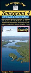
Temagami 4 - Northwest and Sturgeon RiverThe Adventure Map® |
 |
||
| Format | Waterproof folded map | |
| Catalogue No. | 0-929140-80-X | |
| Scale | 1:80,000 | |
| Language | English only | |
| Price | $14.95 | |
| Published by Chrismar Mapping Services, 2011. Description: |
| This map shows the more remote western side of
classic Temagami; the ideal area for a fly-in trip or a lengthy multi-week
route. In addition to a selection of paddling routes through large and small
lakes, there are several great river routes, and even the chance to hike to the
highest elevation in Ontario, Ishpatina Peak. At an ideal paddling scale of 1:80,000, Temagami 4 - Northwest and Sturgeon River map shows considerably more detail than government topos of larger scale. This map shows all or parts of five Provincial Parks as well as several Conservation Reserves that border and help protect them:
The Adventure Map® is specifically designed for outdoor adventurers such as hikers, backpackers, and paddling enthusiasts who need an accurate, up-to-date, rugged map to get them into and safely back from the wilderness. The Adventure Map® is compact (most measure 18" x 24"/45 x 61cm or less), easy to read, and easy to fold. The maps are also waterproof, printed on specially-made, extra tough, waterproof plastic. |
| Price and availability subject to change.
Shipping and applicable taxes extra. Questions about anything on this page? Please e-mail us. This page last modified: July 27, 2011 |
| Temagami main page · Adventure Maps main page · Ontario Parks Maps main page |
| What's New · Home · Search · Books on Canada · Canadian Maps and Charts · Ordering · Contact Us |
©Federal Publications Inc., 1998 - 2011 425 University Avenue, Ste. 401, Toronto, Ontario, Canada M5G 1T6 Phone: (416) 860-1611 or toll-free 1-888-433-3782 · E-mail: info@fedpubs.com |