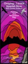
Onaping-Levack, Spanish River and Greater Sudbury West Fishing
& Recreation Map is a full-colour map at a scale of 1:300,000. It is
double-sided, pre-folded, and unfolds to 28" x 40".
The map shows:
- Primary, secondary and tertiary roads
- Hiking trails
- Cross-country ski trails
- Main access locations
- Canoe routes
- Portages
- Unmarked snow trails
- Groomed snowmobile trails
- Fishing hotspots
The coverage area includes Biscotasi Lake Provincial Park,
Halfway Lake Provincial Park, Spanish River Provincial Park and Rushbrook
Provincial Park. |
 |