| FEDERAL PUBLICATIONS INC. |
| |
|
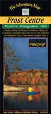
Frost Centre AreaThe Adventure Map® |
 |
||
| Format | Waterproof folded map | |
| Catalogue No. | 0-929140-23-0 | |
| Scale | 1:50,000 | |
| Language | English only | |
| Price | $10.95 | |
| Published by Chrismar Mapping Services, 2009. Description: |
| This 1:50,000 scale map covers over 500 km2 of
wilderness in the Haliburton Highlands/Muskoka Lakes region of Ontario,
including the popular 200 km2 tract of crown land known as the Leslie Frost
Centre. A great destination for paddlers and backpackers alike, this map covers stretches from Livingstone and Fletcher lakes in the north, to Halls Lake in the south and from Lake of Bays to the west to Kennisis and Kimball lakes in the east. The map features hiking trails, campsites, portages, access points, facilities and other attractions. The back side is covered with colour photos and lots of information about natural history, suggested routes, safety tips, contact information and much more. The Adventure Map® is specifically designed for outdoor adventurers such as hikers, backpackers, and paddling enthusiasts who need an accurate, up-to-date, rugged map to get them into and safely back from the wilderness. The Adventure Map® is compact (most measure 18" x 24"/45 x 61cm or less), easy to read, and easy to fold. The maps are also waterproof, printed on specially-made, extra tough, waterproof plastic. |
Price and availability subject to change. Shipping and applicable taxes extra. Questions about anything on this page? Please e-mail us. This page last modified: April 19, 2011 |
| Recreation Maps main page · Adventure Maps main page |
| What's New · Home · Search · Books on Canada · Canadian Maps and Charts · Ordering · Contact Us |
©Federal Publications Inc., 1998 - 2016 425 University Avenue, Ste. 401, Toronto, Ontario, Canada M5G 1T6 Phone: (416) 860-1611 or toll-free 1-888-433-3782 · E-mail: info@fedpubs.com |