| FEDERAL PUBLICATIONS INC. |
| |
|
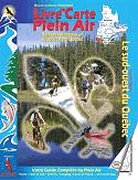
Backroad Mapbook of Southwestern Quebec |
 |
||
| Format | Softcover | |
| Catalogue No. | 1-894556-29-1 | |
| Pages | 111 | |
| Language | Bilingual | |
| Price | $22.95 | |
Written by Christine Butt and Jason Marleau. Published by Mussio Ventures Ltd., 2004. Description: |
| Whether you're
driving, cycling, hiking or camping, find your way with this complete road and
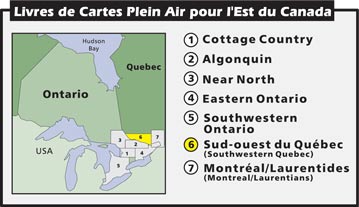
recreation atlas. The Backroad Mapbook of Southwestern Quebec is the most comprehensive outdoor recreation resource available for the area. Locally known as the Outaouais, this is a diverse region that is a favourite destination choice amongst outdoor enthusiasts. The Outaouais is bordered by Abitibi-Temiscamingue, the Laurentians, and Canada's capital city, Ottawa. With a multitude of colourful mountains, rolling hills, deep forests, tame and wild rivers, and over 20 000 lakes, the opportunities for outdoor adventures are endless. Whether you want to hike or ski the many trails in the renowned Gatineau park, take a week off to explore the lakes and rivers of the La Verendrye Wildlife Reserve on a canoe-camping trip, try your hand at fishing some of Temiscamingue's hot spots, or take a leisurely bike-ride through the old-fashioned and inviting towns that populate the Gatineau Valley, the Outaouais offers it all. The reference section includes information on lake and stream fishing, paddling routes, multi-use trails (hiking/biking/ATV), wilderness camping (parks and conservation areas), and winter recreation. The maps highlight the logging/bush road networks, trail systems and recreation opportunities for Southwestern Quebec. Presented in both French and English, the Backroad Mapbook of Southwestern Quebec provides the most detail and accuracy on the road and trail networks of the Outaouais. |
|
 |
|
Also available: Other Backroad Mapbooks |
| Price and availability subject to change.
Shipping and applicable taxes extra. Questions about this product? Please e-mail us. This page last modified: January 10, 2011 |
| Travel in Canada main page · Maps of Quebec main page |
| What's New · Home · Search · Books on Canada · Canadian Maps and Charts · Ordering · Contact Us |
©Federal Publications Inc., 1998 - 2011 425 University Avenue, Ste. 401, Toronto, Ontario, Canada M5G 1T6 Phone: (416) 860-1611 or toll-free 1-888-433-3782 · E-mail: info@fedpubs.com |