| FEDERAL PUBLICATIONS INC. |
| |
|
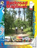
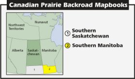
Southern Manitoba Backroad Mapbook |
| September 22, 2008: "Southern Manitoba
Backroad Mapbook" is currently on backorder with the publisher. If you would
like to be notified when this title is available again, please
contact
us. Thank you. |
 |
||
| Format | Spiral-bound | |
| Catalogue No. | 1-894556-66-6 | |
| Pages | 112 | |
| Language | English only | |
| Price | $19.95 | |
| Not available for purchase at this time. |
Written by Linda Aksomitis. Published by Mussio Ventures Ltd., 2005. Description: |
| Whether you're
driving, cycling, hiking or camping, find your way with this complete road and
recreation atlas. The Southern Manitoba Backroad Mapbook is the most comprehensive outdoor recreation resource for this land of diversity, from its Precambrian shield to desert-like sands, and everything in between. As you travel north and south along the Manitoba-Saskatchewan border you will find rolling prairies, along with Riding Mountain National Park and its treasures. Over 900 beautiful lakes, forests, and wildlife make this park a four-season destination to be enjoyed. The Trans-Canada highway travels east through Manitoba's rolling plains to the flat terrain around Winnipeg, where you truly can see forever. As you get closer to the Ontario border you reach Precambrian shield area, with rock outcroppings, pine forests, and opportunities to enjoy the wilderness. The reference section includes information on lake and stream fishing, paddling routes, multi-use trails (hiking/biking/ATV), wilderness camping (parks and conservation areas), and winter recreation. The maps highlight the provincial road networks, trail systems and recreation opportunities for Southern Manitoba. Whether fishing, paddling, ATVing, snowmobiling, or bird watching, the Southern Manitoba Backroad Mapbook is much more than a set of maps - it is an explorer's guide. |
|
 |
|
Also available: Other Backroad Mapbooks |
| Price and availability subject to change.
Shipping and applicable taxes extra. Questions about this product? Please e-mail us. This page last modified: September 22, 2008 |
| Travel in Western Canada main page · Maps of Manitoba main page |
| What's New · Home · Search · Books on Canada · Canadian Maps and Charts · Ordering · E-mail Us |
©Federal Publications Inc., 1998 - 2016 425 University Avenue, Ste. 401, Toronto, Ontario, Canada M5G 1T6 Phone: (416) 860-1611 or toll-free 1-888-433-3782 · E-mail: info@fedpubs.com |