| FEDERAL PUBLICATIONS INC. |
| |
|
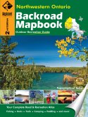
Northwestern Ontario Backroad Mapbook, 2nd Edition |
 |
||
| Format | Spiral-bound | |
| Catalogue No. | 978-1-897225-31-8 | |
| Pages | 165 | |
| Language | English only | |
| Price | $25.95 | |
Written by Trent Ernst. Published by Mussio Ventures Ltd., 2009. Description: |
| Whether you're
driving, cycling, hiking or camping, find your way with this complete road and
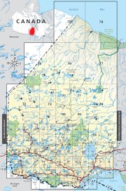
recreation atlas. The Northwestern Ontario Backroad Mapbook, 2nd Edition is the most comprehensive outdoor recreation resource available for the region, a sprawling area that encompasses the Canadian Shield, prairies, and miles upon miles of boreal forest. As you travel west from Nipigon, the landscape passes through canyon country. This is an area marked by sheer cliffs and rugged topography. Further west, the land transforms into the picturesque territory of the Canadian Shield that is characterized by granite rocks, boreal forest, and thousands of lakes. Near the Manitoba border, the rocky landscape gives way to the flatter prairie lands that typify the eastern plains. The immense area of mostly remote wilderness is an asset to this region like no other. For people looking to get away from it all, it is not all that hard to find a place to call your own. There is an established network of trails, canoe routes, portages, and winter routes that compliment the numerous parks and Crown Land campsites that scatter the entire region. Like no other place in Canada, the outdoor enthusiast can find both remote and more convenient settings among beautiful scenery, pristine wilderness, and peaceful surroundings. People interested in motorized transportation (ATVing, snowmobiling) will find this region to be ideal. Established and maintained trails link all the larger urban centres to smaller communities, while lesser-used trails lead to isolated spots hundreds of kilometres away from civilization. The reference section found in this book includes information on paddling routes, lake and stream fishing, camping (parks and conservation areas), multi-use trails (hiking/biking, and off road trails) and winter recreation. Countless hours have been spent in researching this book, making it the most complete compilation of outdoor recreation information you will find on the region anywhere. This information can be enjoyed by anyone who spends time in the great outdoors. The maps in this book highlight the intricate backroad network, trail systems and recreation opportunities in Northwestern Ontario. No other source provides as much detail and accuracy on the road and trail networks of this vast and wonderful section of Ontario. |
|
 |
|
Also available: Other Backroad Mapbooks |
| Price and availability subject to change.
Shipping and applicable taxes extra. Questions about this product? Please e-mail us. This page last modified: April 28, 2009 |
| Travel in Ontario main page · Maps of Ontario main page |
| What's New · Home · Search · Books on Canada · Canadian Maps and Charts · Ordering · Contact Us |
©Federal Publications Inc., 1998 - 2011 425 University Avenue, Ste. 401, Toronto, Ontario, Canada M5G 1T6 Phone: (416) 860-1611 or toll-free 1-888-433-3782 · E-mail: info@fedpubs.com |