| FEDERAL PUBLICATIONS INC. |
| |
|
Nova Scotia Backroad Mapbook, 2nd Edition |
 |
||
| Format | Spiral-bound | |
| Catalogue No. | 978-1-897225-54-7 | |
| Pages | 119 | |
| Language | English | |
| Price | $25.95 | |
Written by Trent Ernst. Published by Mussio Ventures Ltd., 2009. Description: |
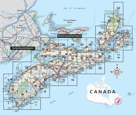
| Whether you're
driving, cycling, hiking or camping, find your way with this complete road and
recreation atlas. The Nova Scotia Backroad Mapbook 2nd Edition is the most comprehensive outdoor recreation resource available for the province. Discover limitless seacoast, and forests, alive with bird and animal life, as well as more than four centuries of European settlement history and centuries of Mi'kmaq traditions. The backroads in Nova Scotia are never far from the sea; in fact no portion of the province is more than 56 km (35 miles) from the ocean. From the mighty salmon producing river, the Margaree, that crosses Cape Breton, to the Mersey River that stretches from north to south, there are some magnificent waterways to lure fishermen and paddlers alike. Mackerel, cod, capelin, hake, flounder, pollack, catfish, blue—mako—or Porbeagel shark are some of the deep sea fishing that helps make Nova Scotia one of Canada's most well known fishing destinations. There is a lot to see and do in Nova Scotia throughout the year. Although the spring fishing, summer seacoast, and fabulous fall colours likely draw the most attention, the Nova Scotia Backroad Mapbook 2nd Edition will help you explore Canada’s seacoast province like no other resource. In addition to the maps, the writing will open your dreams to places you didn't realize even existed. Features:
|
|
 |
|
Also available: Other Backroad Mapbooks |
| Price and availability subject to change.
Shipping and applicable taxes extra. Questions about this product? Please e-mail us. This page last modified: February 22, 2012 |
| Travel in Canada main page · Maps of Nova Scotia main page |
| What's New · Home · Search · Books on Canada · Canadian Maps and Charts · Ordering · Contact Us |
©Federal Publications Inc., 1998 - 2012 425 University Avenue, Ste. 401, Toronto, Ontario, Canada M5G 1T6 Phone: (416) 860-1611 or toll-free 1-888-433-3782 · E-mail: info@fedpubs.com |