| FEDERAL PUBLICATIONS INC. |
| |
|
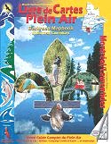
Backroad Mapbook of Montreal/Laurentians |
 |
||
| Format | Softcover | |
| Catalogue No. | 1-894556-42-9 | |
| Pages | 128 | |
| Language | Bilingual | |
| Price | $22.95 | |
Written by Christine Butt and Jason Marleau. Published by Mussio Ventures Ltd., 2004. Description: |
| Whether you're
driving, cycling, hiking or camping, find your way with this complete road and
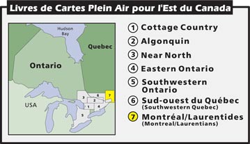
recreation atlas. The Laurentians tourist area upholds an international reputation as being an excellent outdoor recreation destination. This mountainous region offers a selection of some of Québec’s finest summits. Whether you travel on foot, bike, skis or snowmobile, the many trails that explore these hills will be sure to fascinate you. Similarly, the countless lakes and rivers that wind around the mountains present fishermen and paddlers with an unlimited choice of waterways to explore. The Laurentians are especially well known as a ski destination and offers outdoor enthusiasts with a vast territory where they can practice winter recreation activities. The metropolitan city of Montreal also offers its share of parks and trail networks. As an island, there are many nice areas that border the city where you can go for a walk, bike-ride near the Saint-Lawrence River, or take a canoe trip across to neighbouring islands. This guidebook also covers the area of Lanaudière, which borders the east side of the Laurentians area. The Lanaudière area offers beautiful forests, lakes and rivers, as well as vast farmlands that spread from the Saint-Lawrence River in the south to the wooded mountains in the north. The reference section found in this book includes information on lake and stream fishing, paddling routes, multi-use trails (hiking/biking/ATV), wilderness camping (in parks, ZECs and wildlife reserves) and winter recreation. Countless hours have been spent in researching this book, making it the most complete compilation of outdoor recreation information you will find on the region anywhere. Presented in both French and English, this information is useful to anyone who enjoys spending time in the great outdoors. The maps in this book highlight the logging/bush road networks, trail systems and recreation opportunities for the Montreal/Laurentians area. A unique feature of the maps is that all recreation activities are labelled, allowing for quick and easy referencing when researching a specific area. Further, no other source provides as much detail and accuracy on the road and trail networks of the Montreal/Laurentians area. |
|
 |
|
Also available: Other Backroad Mapbooks |
| Price and availability subject to change.
Shipping and applicable taxes extra. Questions about this product? Please e-mail us. This page last modified: January 10, 2011 |
| Travel in Canada main page · Maps of Quebec main page |
| What's New · Home · Search · Books on Canada · Canadian Maps and Charts · Ordering · Contact Us |
©Federal Publications Inc., 1998 - 2011 425 University Avenue, Ste. 401, Toronto, Ontario, Canada M5G 1T6 Phone: (416) 860-1611 or toll-free 1-888-433-3782 · E-mail: info@fedpubs.com |