| FEDERAL PUBLICATIONS INC. |
| |
|
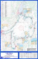
Lake Simcoe Planning Chart |
 |
|||||
| Format | Waterproof | OR | Format | Paper | |
| Catalogue No. | SIMCOE-FP-S | Catalogue No. | SIMCOE-FP-P | ||
| Size | 24" x 37" | Size | 24" x 37" | ||
| Scale | 1:80 000 | Scale | 1:80 000 | ||
| Price | $29.95 | Price | $24.95 | ||
Published by Federal Publications Inc., 2010. Description: |
The Lake Simcoe Planning Chart
is a 1:80 000 chart including water depths (in feet), channel markers,
navigational aids, plus topographic data for the land surrounding the lake. It
also contains a listing of marinas on Lake Simcoe as well as minimum safety
equipment requirements for sail and power boats. It also includes detailed
insets of the following areas:
The Lake Simcoe Planning Chart is normally sent rolled in a tube. If you wish to receive the planning chart pre-folded please indicate your request in the "Shipping Instructions" field of our online order form. Please note: this chart is not to be used for navigation purposes. Only charts produced by Canadian Hydrographic Service are officially sanctioned for navigation. |
 |
| Price and availability subject to change.
Shipping and applicable taxes extra. Questions about this product? Please e-mail us. This page last modified: April 12, 2012 |
| Boating main page · Lake Ontario Chart Index · Depth Maps/Charts |
| What's New · Home · Search · Books on Canada · Canadian Maps and Charts · Ordering · Contact Us |
©Federal Publications Inc., 1998 - 2012 425 University Avenue, Ste. 401, Toronto, Ontario, Canada M5G 1T6 Phone: (416) 860-1611 or toll-free 1-888-433-3782 · E-mail: info@fedpubs.com |