| FEDERAL PUBLICATIONS INC. |
| |
|
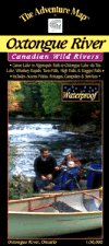
Oxtongue River - Algonquin Provincial ParkThe Adventure Map® |
 |
||
| Format | Waterproof folded map | |
| Catalogue No. | 0-929140-57-5 | |
| Scale | 1:30,000 | |
| Language | English only | |
| Price | $6.95 | |
| Published by Chrismar Mapping Services, 2001. Description: |
| This 1:30,000 scale map of the Oxtongue River area
covers the river itself and adjacent sections of Algonquin Park. There are
several access points and routes to choose from including the Oxtongue River
itself (either downstream or upstream), Oxtongue lake, or the Park Lake to
Bluebell Lake section of Algonquin. Highlights along the routes include thundering Ragged Falls, Whiskey Rapids, Twin Falls, and High Falls. With campsites, portages, access points, rapids, falls, historic features, hiking trails, facilities and lots of other helpful information this map makes an excellent resource for daytrippers and those seeking a short two to three day adventure. The Adventure Map® is specifically designed for outdoor adventurers such as hikers, backpackers, and paddling enthusiasts who need an accurate, up-to-date, rugged map to get them into and safely back from the wilderness. The Adventure Map® is compact (most measure 18" x 24"/45 x 61cm or less), easy to read, and easy to fold. The maps are also waterproof, printed on specially-made, extra tough, waterproof plastic. |
| Price and availability subject to change.
Shipping and applicable taxes extra. Questions about anything on this page? Please e-mail us. This page last modified: August 6, 2008 |
| Algonquin Park main page · Ontario Parks Maps main page |
| What's New · Home · Search · Books on Canada · Canadian Maps and Charts · Ordering · Contact Us |
©Federal Publications Inc., 1998 - 2011 425 University Avenue, Ste. 401, Toronto, Ontario, Canada M5G 1T6 Phone: (416) 860-1611 or toll-free 1-888-433-3782 · E-mail: info@fedpubs.com |