| FEDERAL PUBLICATIONS INC. |
| |
|
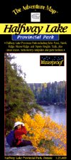
Halfway Lake Provincial ParkThe Adventure Map® |
 |
||
| Format | Waterproof folded map | |
| Catalogue No. | 0-929140-81-8 | |
| Scale | 1:25,000 | |
| Language | English only | |
| Price | $8.95 | |
| Published by Chrismar Mapping Services, 2001. Description: |
| This compact provincial park sits on the Canadian
Shield about an hour north of Sudbury. Easily accessible by highway, Halfway
Lake Provincial Park has a fine combination of great hiking trails with
exceptional viewpoints, and several little-used, but excellent backcountry
canoe routes. This 1:25,000 scale map shows trails, lakes, streams, wetlands, open areas, extraordinary contour detail and much more. The map includes the Echo Pond, Hawk Ridge, Moose Ridge, and Osprey Heights trails, plus canoe routes, backcountry campsites and park facilities. The Adventure Map® is specifically designed for outdoor adventurers such as hikers, backpackers, and paddling enthusiasts who need an accurate, up-to-date, rugged map to get them into and safely back from the wilderness. The Adventure Map® is compact (most measure 18" x 24"/45 x 61cm or less), easy to read, and easy to fold. The maps are also waterproof, printed on specially-made, extra tough, waterproof plastic. |
| Price and availability subject to change.
Shipping and applicable taxes extra. Questions about anything on this page? Please e-mail us. This page last modified: April 19, 2011 |
| Ontario Parks Maps main page |
| What's New · Home · Search · Books on Canada · Canadian Maps and Charts · Ordering · Contact Us |
©Federal Publications Inc., 1998 - 2011 425 University Avenue, Ste. 401, Toronto, Ontario, Canada M5G 1T6 Phone: (416) 860-1611 or toll-free 1-888-433-3782 · E-mail: info@fedpubs.com |