| FEDERAL PUBLICATIONS INC. |
| |
|
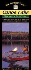
Canoe Lake - Algonquin Provincial ParkThe Adventure Map® |
 |
||
| Format | Waterproof folded map | |
| Catalogue No. | 0-929140-54-0 | |
| Scale | 1:40,000 | |
| Language | English only | |
| Price | $6.95 | |
| Published by Chrismar Mapping Services, 2005. Description: |
| This popular 1:40,000 scale map covers the area from
Ragged Lake in the south to Joe Lake in the north and from Tea Lake in the west
to Source Lake in the east, including the busy Canoe Lake and Smoke Lake access
points. The text and pictures on the reverse side describe the former logging boom town of Mowat, artist Tom Thomson and his mysterious death and local nursing legend Molly Colson, as well as hiking trails, park facilities and trip tips. The Adventure Map® is specifically designed for outdoor adventurers such as hikers, backpackers, and paddling enthusiasts who need an accurate, up-to-date, rugged map to get them into and safely back from the wilderness. The Adventure Map® is compact (most measure 18" x 24"/45 x 61cm or less), easy to read, and easy to fold. The maps are also waterproof, printed on specially-made, extra tough, waterproof plastic. |
| Price and availability subject to change.
Shipping and applicable taxes extra. Questions about anything on this page? Please e-mail us. This page last modified: August 6, 2008 |
| Algonquin Park main page |
| What's New · Home · Search · Books on Canada · Canadian Maps and Charts · Ordering · E-mail Us |
©Federal Publications Inc., 1998 - 2016 425 University Avenue, Ste. 401, Toronto, Ontario, Canada M5G 1T6 Phone: (416) 860-1611 or toll-free 1-888-433-3782 · E-mail: info@fedpubs.com |