| FEDERAL PUBLICATIONS INC. |
| |
|
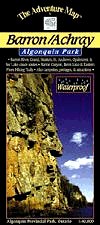
Barron/Achray - Algonquin Provincial ParkThe Adventure Map® |
 |
||
| Format | Waterproof folded map | |
| Catalogue No. | 0-929140-15-X | |
| Scale | 1:40,000 | |
| Language | English only | |
| Price | $8.95 | |
| Published by Chrismar Mapping Services, 2008. Description: |
| The dominant feature of this popular area on the
east side of Algonquin Park is the 100-metre deep Barron Canyon, but there are
other great attractions too, including High Falls, Brigham Chutes, the Barron
River, old log drive relics and much more, all detailed on this 1:40,000 scale
map. The back side includes, as always, colour photos of the area and text about local flora and fauna, suggested routes, safety concerns and contact info. Also covers the Sec/Mallard Lakes area. The Adventure Map® is specifically designed for outdoor adventurers such as hikers, backpackers, and paddling enthusiasts who need an accurate, up-to-date, rugged map to get them into and safely back from the wilderness. The Adventure Map® is compact (most measure 18" x 24"/45 x 61cm or less), easy to read, and easy to fold. The maps are also waterproof, printed on specially-made, extra tough, waterproof plastic. |
| Price and availability subject to change.
Shipping and applicable taxes extra. Questions about anything on this page? Please e-mail us. This page last modified: February 2, 2009 |
| Algonquin Park main page |
| What's New · Home · Search · Books on Canada · Canadian Maps and Charts · Ordering · E-mail Us |
©Federal Publications Inc., 1998 - 2016 425 University Avenue, Ste. 401, Toronto, Ontario, Canada M5G 1T6 Phone: (416) 860-1611 or toll-free 1-888-433-3782 · E-mail: info@fedpubs.com |