| FEDERAL PUBLICATIONS INC. |
| |
|
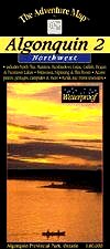
Algonquin 2 - NorthwestThe Adventure Map® |
 |
||
| Format | Waterproof folded map | |
| Catalogue No. | 0-929140-14-1 | |
| Scale | 1:80,000 | |
| Language | English only | |
| Price | $14.95 | |
| Published by Chrismar Mapping Services, 2007. Description: |
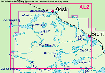
| The Algonquin 2 - Northwest Adventure
Map® covers the entire northwest quadrant of the park. The map overlaps
the north edge of Algonquin 1 - Corridor North and stretches from
Kawawaymog Lake outside the west park boundary all the way to Brent on Cedar
Lake. At a scale of 1:80 000, the Algonquin 2 - Northwest map includes
campsites, portages, and historic features. The back side is covered with
colour photos and text detailing the natural and human history of the area
along with suggested routes, safety tips, and contact info. The Adventure Map® is specifically designed for outdoor adventurers such as hikers, backpackers, and paddling enthusiasts who need an accurate, up-to-date, rugged map to get them into and safely back from the wilderness. The Adventure Map® is compact (most measure 18" x 24"/45 x 61cm or less), easy to read, and easy to fold. The maps are also waterproof, printed on specially-made, extra tough, waterproof plastic. |
 |
Price and availability subject to change. Shipping and applicable taxes extra. Questions about anything on this page? Please e-mail us. This page last modified: February 2, 2009 |
| Algonquin Park main page · Ontario Parks Maps main page |
| What's New · Home · Search · Books on Canada · Canadian Maps and Charts · Ordering · E-mail Us |
©Federal Publications Inc., 1998 - 2016 425 University Avenue, Ste. 401, Toronto, Ontario, Canada M5G 1T6 Phone: (416) 860-1611 or toll-free 1-888-433-3782 · E-mail: info@fedpubs.com |